Danger is not only in heaven
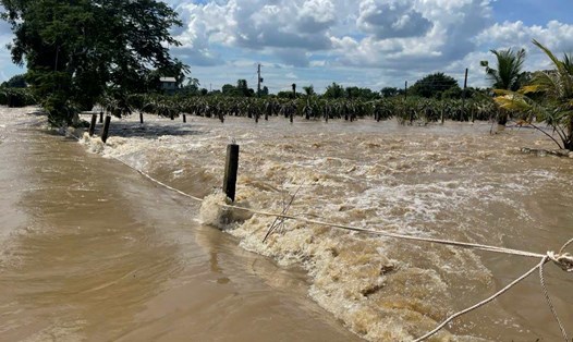
The North Central region has complex terrain and geology with more than 70% of the area being mountainous, stronglystered geological foundation, short river and stream network and slopes. This is a "natural condition" that can easily cause slopes and riverbank erosion during heavy rain. In recent years, extreme rain has increased in both frequency and intensity. At the end of September 2025, the circulation of storm No. 10 (Bualoi) recorded many places with rain exceeding 350mm in a short time, showing that "huge rainfall" is appearing heavier. Obviously, climate change has strongly affected the North Central provinces.
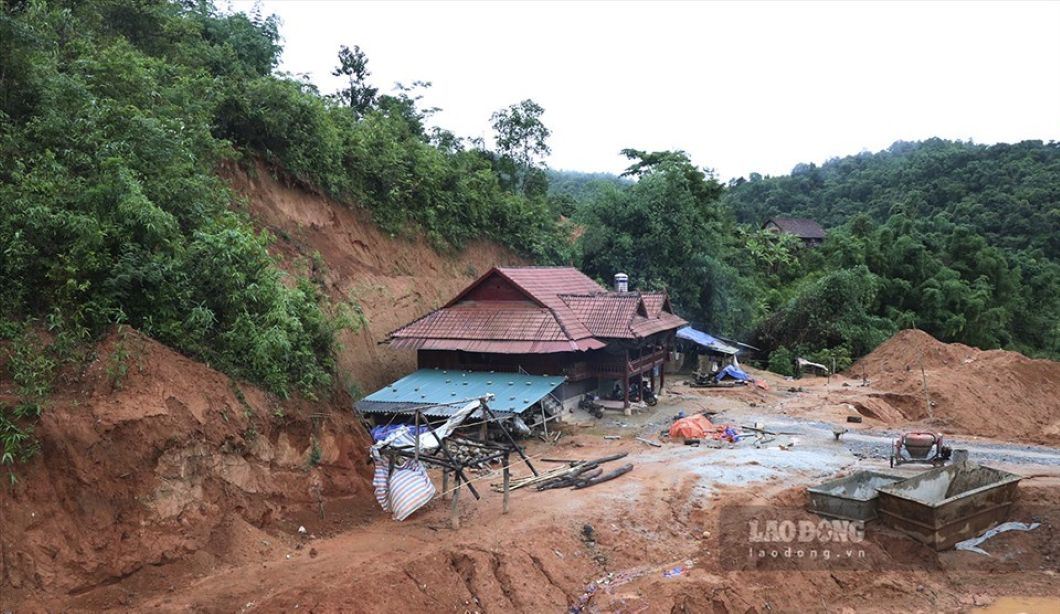
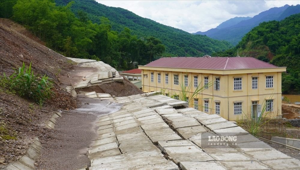
In addition to natural factors, human impact is "accelerating" and "expanding" the level of danger. One is the loss of protective forests due to exploitation or conversion of land use purposes, causing the coverage to decrease and the tree roots no longer anchor the soil. Two is the practice of cutting the hills to make house foundations, burning nests for planting in some mountainous communes, creating unstable artificial slopes. Third, resettlement is arranged after the flood right at the foot of the slope, lacking a top ditch and drainage system, leading to landslides next year right at the site of the previous transfer. Four is illegal sand and gravel mining on major rivers, lowering the riverbed, changing the flow direction and digging deep into the foot of the banks.
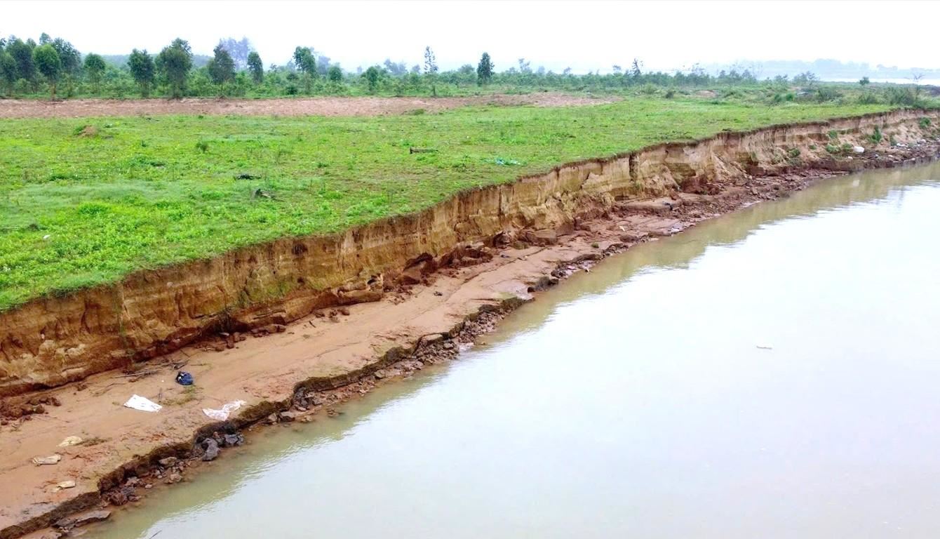
On the Lam River, a typical hot spot in the North Central region, Nghe An's agricultural sector has reported that over the years, the bank has been eroded, losing about 561 hectares of land, affecting hundreds of households and many infrastructure works. Many sections of the shore have encroached 30 - 50m deeper than before, with direct threats to National Highway 7 and residential areas. The locality and people have reported that in addition to flood factors and fluctuations in flow, illegal sand mining is one of the factors that accelerate erosion. In Thanh Hoa, the authorities have set up checkpoints and handled many cases of illegal sand dredging on the Ma River, showing that if there is no discipline, all embankments will be like a strip of ribbon stuck on an open wound.
Recognizing the correct level of each group of causes in each locality is a prerequisite to propose solutions in the right place and at the right level.
Don't let "water get to your feet to dance"
We urgently need to have a map of flash flood and landslide risks with an alert and monitoring system, JICA in Vietnam recommends. The Institute of Geological Sciences and Mineral Resources in recent years has created a landlide warning zoning map at a scale of 1:40,000 for 37 mountainous provinces; many localities, including Thanh Hoa and Nghe An, have been handed over products and trained for use. In 2024, a new set of technical criteria for zoning the risk zone was announced, allowing the integration of layers of information on terrain, geology, carpets, rain, population, traffic, and key projects into risk analysis.
On that basis, the Government approved the Project to warn of early landslides and flash floods for 37 mountainous and midland provinces in 2023; in March 2024, the Ministry of Natural Resources and Environment issued an implementation plan. This is a policy framework for provinces to merge risk data into planning, investment and response command.
According to Mr. Nguyen Van Tuan - Deputy Director of the Department of Construction of Thanh Hoa province, the current problem is that the provinces need to "localize" data for daily use. Each commune needs a layer of raw data that is updated periodically.
Studies have also shown that each mountainous commune needs to have a map of an escape route, a safe gathering point, and a village shock team trained to early recognize signs of landslides such as cracked roofs, changing color of water flows, seeping into slopes, and leaning trees. It is necessary to effectively apply scientific research and modern warning measures instead of folk experience and waiting for "water to step before dancing".
The United Nations has stressed: Every $1 invested in early warning can save $6 in damage. Localities need to allocate stable capital to automatic rain gauge networks, update risk maps, build warning systems and pilot soft embankment projects as social investment, not short-term relief spending.
"It is necessary to improve the capacity of commune-level cadres after the merger to have knowledge, grasp the area and quickly have quick and accurate warnings to help people avoid disasters" - Mr. Ngo Hoang Ky - former Chief of Office of Thanh Hoa Provincial People's Committee - said.
In the North Central region, the development of a risk warning map solution must be a mandatory appendix in all decisions on land, construction licensing, and resettlement arrangements. Not approving the resettlement area in the landslide site, not allowing the construction of public works right at the foot of the newly leveled slope, only arranging residents in locations with stable slope indexes that meet requirements after having a plan to drain peak and groundwater drainage.
Most of the slope incidents originate from surface water and seepage. Therefore, the backbone of stable techniques is drainage. For the riverbank, instead of "facing" directly with long concrete strips, the soft embankment solution along the deep reach road combined with a stone basket to prevent the flow allows the water flow to be controlled without hitting the foot of the bank. The hard embankment should only be applied in places that need immediate protection such as right next to houses, schools, hospitals, and public service headquarters.
An indispensable pillar of management is the establishment of a riverbank safety corridor and tightening sand and gravel exploitation. Each river needs to have its safety corridor boundary announced based on multi-year erosion data. Every sand mine must have a clear boundary coordinate, monitor the riverbed in real time and be subject to independent supervision. The sections of the river that have been deeply dredged need to be completely closed for exploitation. Practice in Thanh Hoa shows that when establishing inter-sectoral checkpoints and strictly handling illegal mining lines, the erosion rate in some hot sections has slowed down, creating a "breath gap" for technical solutions to promote their effectiveness.
Acting with science and knowledge
Along with that, it is necessary to restore upstream protective forests with native trees that are wind-resistant and water-resistant, avoiding planting monolets that are prone to falling. In mountainous communes, it is necessary to end the situation of cutting hills to build houses through propaganda combined with practical alternatives. The government needs to proactively survey the land fund to flatten, even level part of the hill to arrange a safe residential area with a synchronous drainage system. This is a long-term preventive investment, not a temporary cost.
Regarding implementation, the provincial and commune levels need to clearly divide roles: Which agencies update risk warning maps, which agencies approve resettlement locations, which agencies operate warnings and close roads when the rain reaches thresholds, which agencies monitor sand mines and riverbank corridors. When a project embankment is unfinished or technically incorrect, there must be sanctions against the investor and contractor, avoiding the situation of "there is no more than the flood season".
Landslides in the North Central region are not a destination. Nature is inherently harsh, but it is human indifference to nature that makes the consequences more serious. It is time to demonstrate respect for nature and seriously apply science in the ward to avoid landslides.