
On September 7, Dong Nai City Hydrometeorological Station said that the water level in the upstream area of the Dong Nai River system is quite high. The water level at 7 am on September 7 at Ta Lai station (Dong Nai River) was 112.19m above alarm level 1 and at Phu Hiep station (La Nga River) was 104.91m above alarm level 1.
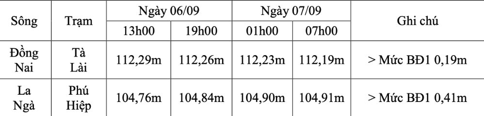
Flood alert level may occur on the Dong Nai River and on the La Nga River at alarm level 1. It is necessary to prevent the possibility of heavy rain combined with floods causing flooding, landslides on riverbanks, streams, low-lying areas in communes and wards: Dak Lua, Nam Cat Tien, Ta Lai, Thanh Son, Phu Vinh, Phu Lam, Tan Phu, Phu Hoa, Dinh Quan in Dong Nai City and neighboring areas.
The water level on rivers and streams in the upstream areas of the Dong Nai river system is quite high, with the risk of flooding low-lying areas along rivers and streams, adversely affecting waterway traffic, aquaculture, and agricultural production in rivers, streams, riverbanks, and stream banks.
The Dong Nai River is about 586 km long, originating from the Langbiang plateau (or Lam Vien plateau) in Lam Dong province and flowing into the East Sea. The Dong Nai River is the longest river located entirely within Vietnamese territory.


