The time when the tropical depression strengthens into a storm and makes landfall
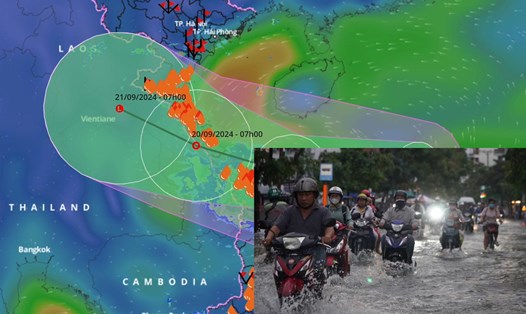
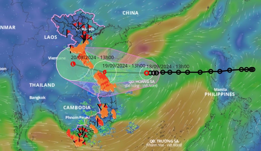
According to information from the Department of Dyke Management and Natural Disaster Prevention and Control, at 10:00 a.m. on September 18, the center of the tropical depression was at about 16.7 degrees North latitude, 113.5 degrees East longitude, about 180km east of Hoang Sa archipelago with intensity of level 7, gusting to level 9.
It is forecasted that by 10am on September 19, it will strengthen into a storm with a level 8 intensity, gusting to level 10, with the center of the storm in the coastal waters from Quang Tri to Quang Nam, about 110km east-southeast of Quang Tri. On the afternoon of September 19, the storm will make landfall in Quang Tri - Quang Nam, then weaken.

The tide level at the time the storm is expected to make landfall (from 5pm on September 19 to 7am on September 20) at Cua Gianh (Quang Binh) stations is from 0.7 - 1.8m; Cua Viet (Quang Tri) from 0.7 - 1.4m; Da Nang (Da Nang) from 0.7 - 1.3m.
The Department of Dyke Management and Natural Disaster Prevention and Control said that from September 18 to 19, from Ha Tinh to Quang Ngai, there will be heavy to very heavy rain from 100 - 300mm, some places over 500mm. Thanh Hoa and Nghe An will have 70 - 150mm, some places over 250mm. The Central Highlands will have 40 - 80mm, some places over 150mm.
From September 18 to 21, rivers from Thanh Hoa to Quang Nam experienced a flood, with flood amplitudes ranging from 3 to 7 meters. The flood peaks of the upstream Ma River, Buoi River (Thanh Hoa), and the upstream Ca River (Nghe An) reached alert level 1 (BD1) - BD2 and above BD2. Ngan Sau and Ngan Pho Rivers (Ha Tinh) reached BD2 - BD3. The downstream Ma River (Thanh Hoa), La River (Ha Tinh), and Ca River (Nghe An) were at BD1. Rivers from Quang Binh to Quang Nam were at BD1 - BD2, with some rivers above BD2. Small rivers in Quang Binh and Quang Tri were likely to reach BD3.
There is a high risk of flooding in low-lying areas along rivers, flash floods and landslides on steep slopes in mountainous areas from Thanh Hoa to Quang Nam.
Resolutely call and guide ships to shelters
Strictly implementing the Prime Minister's Official Dispatch No. 97/CD-TTg dated September 17, 2024, the Ministry of Agriculture and Rural Development requests that provinces and cities closely monitor the developments of the storm, focusing on resolutely calling on and guiding ships and vehicles (including cruise ships and transport ships) still operating at sea and along the coast to proactively escape from dangerous areas or return to shelters, in which they grasp detailed information of each ship in the area at risk of being affected by the tropical depression that is likely to strengthen into a storm.
Organize the arrangement of boats at anchorage to ensure safety. Proactively prohibit the sea according to the storm's developments. Resolutely do not let people stay on cages, rafts, and watchtowers when the storm hits; have plans to ensure the safety of tourists and people on the islands.
For plains and coastal areas, specifically review and prepare evacuation plans for unsafe houses, low-lying river mouths and coastal areas. Have plans for students to stay home from school during storms.
In addition, provide guidance on harvesting and ensure aquaculture. Absolutely do not let people stay on cages, rafts, and watchtowers when the storm hits.
The Ministry requires work to ensure the safety of key sea dykes and river dykes that are vulnerable or under construction. Organize tree pruning, reinforce houses, buildings, advertising signs, and power grid systems.
Concentrate on harvesting rice fields that are ready for harvest with the motto "green house is better than old field". Check drainage system, ready to drain water to protect agricultural production, low-lying areas, urban areas and industrial zones.
For mountainous areas, deploy shock forces to inspect and review residential areas along rivers, streams, low-lying areas, and areas at high risk of flooding, flash floods, and landslides to proactively evacuate people to safety.
Be ready to organize forces to guard and control traffic at culverts, spillways, deeply flooded areas, and areas at risk of landslides. Resolutely do not allow people and vehicles to pass if safety is not ensured; arrange forces, prepare materials and means to overcome traffic problems.
At the same time, check and prepare plans to ensure the safety of reservoirs and downstream areas, especially small hydroelectric reservoirs and important irrigation reservoirs. Arrange a permanent force to be ready to operate, regulate and handle situations.