The storm made landfall in the North on the evening of September 7.
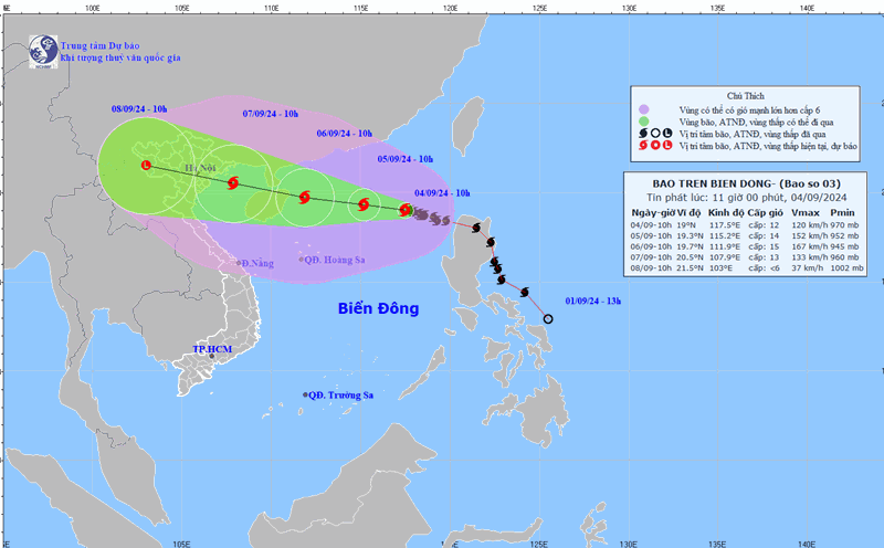
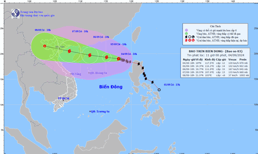
The Department of Dyke Management and Natural Disaster Prevention and Control said that at 10:00 a.m. on September 4, the center of storm No. 3 was at 19.0 degrees North latitude, 117.5 degrees East longitude, about 730km east of Hainan Island (China), with a level 12 intensity, gusting to level 15.
The storm is forecast to move west at a speed of 10-15km/h; continue to strengthen, reaching a maximum intensity of level 14-15, gusting to level 17 in the sea area east of Hainan Island (China). Natural disaster risk level 4 for the northern part of the North East Sea on September 5-6, 2024.
Around the evening of September 7, the storm will make landfall in the Northern mainland (from Quang Ninh to Ninh Binh). The highest waves will be 9.0 - 11.0m on September 5 - 6, 2024.
The highest tide at Hon Dau station is 2.0m at 17:00 on September 7, 2024 (during low tide).
Regarding the situation of boats, according to the report of the Border Guard Command, 50,137 fishing boats/219,864 people have been counted and guided, of which 504 boats/3,356 people are operating in the North East Sea and Hoang Sa archipelago (dangerous area). Of which: Thanh Hoa 2 boats/20 people; Nghe An 135 boats/523 people; Da Nang 54 boats/479 people; Quang Nam 141 boats/1,133 people; Quang Ngai 157 boats/1,111 people; Binh Dinh 15 boats/90 people. The vehicles have received the information and are moving to take shelter.
Quang Ninh, Thai Binh and Nam Dinh provinces are expected to ban fishing from September 6, 2024.
Regarding the aquaculture situation, coastal areas and sea areas of provinces and cities from Quang Ninh to Nghe An currently have 49,380 hectares, 19,144 cages, rafts and 3,806 aquaculture watchtowers. There is a very high risk of damage when the storm enters the Gulf of Tonkin with intensity of level 12 - 13, gusting to level 16.
Update on reservoir and dike situation
Regarding the situation of reservoirs and inter-reservoirs of hydropower plants in the Red River basin at 11:00 a.m. on September 4, the upstream water levels of the reservoirs/normal rising water levels are as follows: Son La: 208.32m/215m; Hoa Binh: 111.45m/117.0m; Tuyen Quang: 117.15m/120.0m; Thac Ba: 58.05m/58.0m. Currently, Tuyen Quang reservoir is opening 1 bottom spillway; Thac Ba reservoir is opening 2 surface spillways.
Regarding the situation of irrigation reservoirs in the North, there are 2,543 reservoirs, with a capacity of 80-96% of the design capacity; currently, there are 120 damaged and degraded reservoirs and 77 reservoirs under construction.
The North Central region has 2,323 reservoirs, with low capacity reaching 46 - 65% of the design capacity; currently there are 140 damaged and degraded reservoirs and 63 reservoirs under construction [3].
Regarding the situation of dikes, on the sea dikes and river estuaries of coastal provinces from Quang Ninh to Nghe An, there are 32 key weak dike points that need special attention (Quang Ninh: 2, Hai Phong 10, Thai Binh 08, Nam Dinh 08, Ninh Binh 3, Thanh Hoa 1); 3 projects are under construction (02 sluices on the Ha Nam dike line, Quang Ninh province; repairing and upgrading sea dike I, Hai Phong city); some dike and embankment locations have had incidents but have not been handled or repaired (Thinh Long embankment on the Hai Hau sea dike line, Nam Dinh); Binh Minh 4 dike line, Ninh Binh province has just been completed but the surface and slope on the field side have not been reinforced.
The sea dikes are currently designed to withstand storms of level 9-10, average tides of 5%; there is a high risk of damage when storms enter the Gulf of Tonkin with intensity of level 12-13, gusts of level 16 (exceeding the design level).