According to the Department of Transport of Ho Chi Minh City, the coastal road connecting Ho Chi Minh City with the provinces of the Mekong Delta has been included in the planning project of Ho Chi Minh City for the period 2021-2030, with a vision to 2050, and the project to adjust the general planning of Ho Chi Minh City to 2040, with a vision to 2060.
According to research, the southern coastal road connecting Ho Chi Minh City with the Mekong Delta is about 428km long.
This coastal route passes through Ho Chi Minh City, Tien Giang, Ben Tre, Tra Vinh, Soc Trang, Bac Lieu and Ca Mau. The project has a scale of 4 lanes, with a design speed of 80km/h in phase 1.
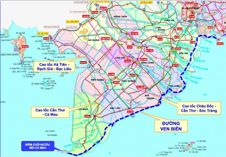
The route passing through Ho Chi Minh City is nearly 21km long, starting from the city's North-South axis.
It is noteworthy that Ho Chi Minh City is researching an additional branch 2 to connect this route through the Can Gio International Transit Port area, located on Phu Loi Islet, Can Gio District.
The Can Gio international transit port project has a total investment of more than 113,000 billion VND (about 4.8 billion USD), expected to become one of the largest ports in Southeast Asia.
This additional branch will connect Can Gio port with Phuoc An port (Dong Nai) and Ben Luc - Long Thanh expressway, creating a complete traffic system between major seaports in the region.
The construction of the coastal route is considered to bring many benefits to Ho Chi Minh City and the Western provinces, not only helping to shorten travel time but also creating favorable conditions for transporting goods from the Western provinces to major ports of Ho Chi Minh City and Dong Nai for export.
When this coastal route is completed, traffic between Ho Chi Minh City, Dong Nai and the Western provinces will be significantly improved, helping to reduce traffic pressure on existing routes and contributing to the development of economic and social infrastructure in the region.