This is one of the contents in the Project to adjust the general planning of Ho Chi Minh City to 2040, with a vision to 2060, which has just been submitted by the Ho Chi Minh City People's Committee to the Prime Minister for approval.
According to this planning project, Ho Chi Minh City will apply comprehensive infrastructure solutions to control flooding, including three layers: protective layer, adaptive layer and damage reduction layer, while making the most of the existing infrastructure system combined with investment in the construction of new projects.
In the group of " adaptative layer" solutions, Ho Chi Minh City will invest in building a regulating lake system to minimize flooding caused by heavy rain, especially in areas within the dyke system, embankments and flood control corridors.
These regulatory lakes can be open or underground works, combined with natural canals, low-lying areas such as semi-flooded parks and green infrastructure according to the principle of scoop urban area - on-site drainage.
Notably, the regulating lake system and natural canals are considered the city's "main reservoirs". Therefore, the protection, retention and opening of existing canals is given the highest priority. In addition, inter-regional canals will be reconnected to distribute water storage capacity evenly to the entire urban area.
Along with that, Ho Chi Minh City will build pumping stations to proactively regulate the water level in the reservoir, supporting drainage when heavy rain and high tides occur at the same time. tidal sluices (wned in one direction, still allowing ships to circulate) will play a role in controlling the water level in the lake, ensuring effective water storage function.
In fact, flood prevention solutions using regulating lakes are not new in Ho Chi Minh City.
Ho Chi Minh City once planned to build 103 regulating lakes with a total area of about 875 hectares.
In the 2016 - 2020 period, the Ho Chi Minh City Flood Control Program Management Center (now the Ho Chi Minh City Urban Infrastructure Construction Investment Project Management Board) proposed to prioritize three lakes: Go Dua (Thu Duc City, 95 hectares - first phase 25 hectares), Bau Cat (Tan Binh District, 4 hectares) and Khanh Hoi (District 4, 4.8 hectares) with a total capital of more than 950 billion VND, but has not yet been implemented due to procedures, capital and site clearance problems.
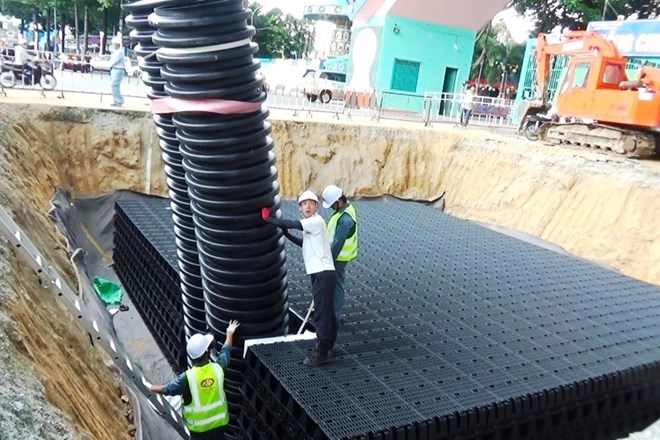
In August 2017, the city piloted the construction of an underground regulating lake on Vo Van Ngan Street (Thu Duc City), with a capacity of about 100 m3. Although it helps reduce flooding, the effectiveness is still limited in heavy rains.
At the end of 2018, the Ho Chi Minh City Center for the Flood Control Program Management continued to propose 7 regulating lakes (6 underpasses, 1 opening) with a total capital of 475 billion VND, including: Lang Hoa Park (Go Vap) 20,000 m3; Hoang Van Thu Park (Tan Binh) 10,000 m3; Tran Thien Chanh residential area (District 10) 5,000 m3; Phan Xich Long Street (Phu Nhuan) 2,000 m3; Saigon - Dien Bien Phu bridge 4,000 m3. However, up to now, all projects have not been implemented.
In 2021, Ho Chi Minh City approved the Project on flood prevention and wastewater treatment 2020 - 2045, in which it continued to emphasize the role of regulating lakes.
In the first phase (2020 - 2030), it is expected to invest about 1,500 billion VND to build 7 lakes in low-lying areas, but there is currently no specific location determined.