According to the draft General Plan of the City for the period 2025 - 2050, 100-year vision, Ho Chi Minh City organizes space according to 10 development governance zones.
This will be the new territorial management framework of Ho Chi Minh City, in which each region is defined according to its key functions, natural conditions, infrastructure, environment and development management requirements.
According to the orientation, the 10-region system will be the basis for population distribution, employment, industry, services, tourism, ecological space and infrastructure investment resources, towards balanced development, reducing pressure on the central area and strengthening regional linkages.
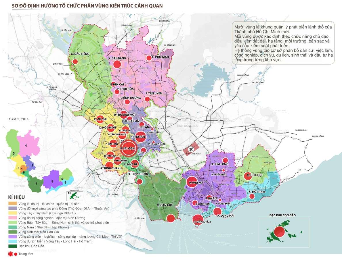
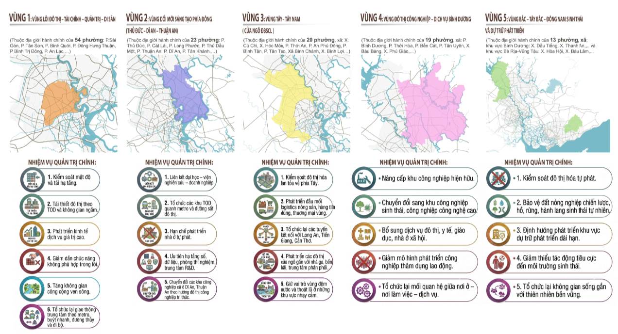
Region 1: Urban core - finance - governance - heritage
This is the international operating, financial and image center of Ho Chi Minh City, including the Saigon, Cho Lon, Thu Thiem areas and the two banks of the Saigon River.
Development orientation focuses on international finance, high-end services, culture, heritage, foreign affairs and riverside public space. This area will be rebuilt according to the TOD model, expanding underground space, developing public transport by metro, rapid buses, waterways and pedestrian networks, and gradually removing unsuitable functions from the core area.
Region 2: Innovation pole in the East
This area includes Thu Duc, Di An, Thuan An and the connecting area of Long Thanh airport, which is identified as the innovation center of the City.
Development orientation focuses on high technology, research and development (R&D), universities, digital economy, fintech, data centers, startups and high-tech manufacturing. At the same time, old industrial parks in Di An and Thuan An will gradually transform into knowledge-based industrial urban areas.
Region 3: West - Southwest, gateway to the Mekong Delta
As the gateway connecting Ho Chi Minh City with the Mekong Delta, this region is planned to become a logistics, clean industry, biomedical and flood-resistant urban center.
In addition to developing logistics centers, warehouses and traffic hubs in Tan Kien, the area also plays the role of a buffer zone for water storage, flood drainage and controlling the urbanization process towards the West.
Region 4: Binh Duong Industrial - Service Urban Area
Considered the "production rear" of the Ho Chi Minh City megacity, this region continues to promote its industrial strengths but in a green and modern direction.
Existing industrial parks will be upgraded into ecological and high-tech industrial parks; at the same time, supplementing social housing, education, healthcare and urban services to form an integrated production - urban - service model.
Region 5: Ecology and development reserves
Including the Northern, Northwest Binh Duong and Southeast Vung Tau regions, this is an ecological balance zone and strategic reserve land fund of the City.
Planning prioritizes protecting forests, water surfaces, agricultural land, ecological corridors, developing high-tech agriculture, suitable ecotourism and renewable energy, while strictly controlling the spontaneous urbanization process.
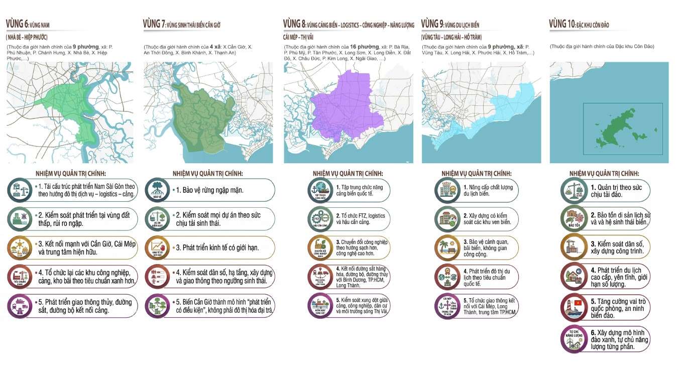
Region 6: South - Nha Be - Hiep Phuoc
This will be the urban - port - logistics development pole in the South, playing a role in connecting the city center with Can Gio and the seaport system.
Development orientation focuses on seaports, logistics, clean industry, cargo distribution centers and waterway transport, while still strictly controlling construction in low-lying areas to adapt to climate change and flooding risks.
Region 7: Can Gio Marine Ecology
Can Gio continues to be identified as the "green lung" and biosphere reserve of Ho Chi Minh City.
All development activities must comply with the load-bearing capacity of the ecosystem. The city prioritizes mangrove forest conservation, blue sea economic development, controlled ecotourism and minimizing mass urbanization.
Region 8: Seaport - logistics - industry - energy
Taking Cai Mep - Thi Vai as the nucleus, this area is planned to become the international maritime gateway of Ho Chi Minh City and the Southern region.
Development orientations include deep-water ports, free trade zones (FTZ), international logistics, port industry, energy and a multimodal transportation network connecting with Binh Duong, Long Thanh and the center of Ho Chi Minh City.
Region 9: Vung Tau - Long Hai - Ho Tram beach tourism
This area is oriented to develop into a high-quality coastal tourism urban chain with resort products, health care, sea sports and night economy.
The plan requires protecting beaches, natural landscapes, limiting coastal concretization, and improving infrastructure quality and connecting traffic with Long Thanh, Cai Mep and the center of Ho Chi Minh City.
Region 10: Con Dao Special Zone
Con Dao is identified as a unique ecological - heritage - defense space, developing according to a model of preservation going hand in hand with sustainable exploitation.
Focusing on high-end tourism with control, preserving marine and island ecosystems and historical and cultural values, controlling population size, limiting the construction and development of green infrastructure and gradually moving towards a green island model, partially autonomous in energy.


