Digital platforms serving people
Recently, Quang Tri Provincial Police in coordination with MobiFone Quang Tri officially put into operation the Commune-level Police Address Digital Map System.
This is a modern digital platform, towards the goal of "Data Connection - Serving the People - Maintaining Security", contributing to improving the efficiency of management, command, and administration of grassroots police forces.
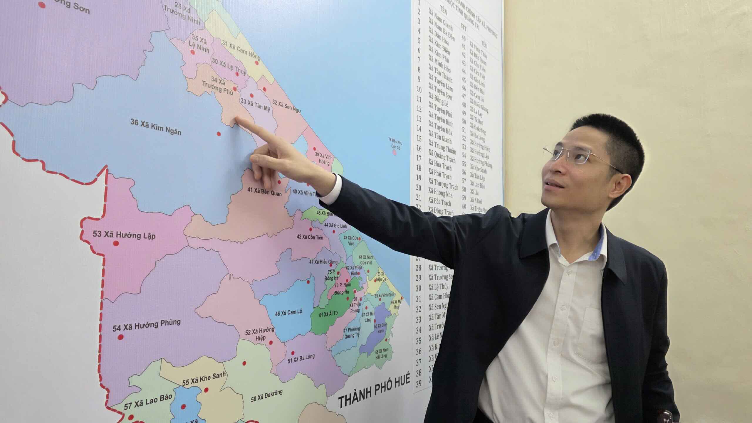
The system is built on the Google Maps platform, has an intuitive interface, is easy to use, and is suitable for many different target groups, from people to police officers and soldiers.
On the map, users can easily look up the addresses of commune, ward, and special zone police headquarters throughout the province; determine the location of administrative units; points of public service provision and list of administrative services being deployed at commune-level police.
Talking to Lao Dong Newspaper, Mr. Van Hai, residing in Dong Hoi ward, Quang Tri province, said that after directly operating on the digital map, he found the search for information very convenient.
Just open the map, I can immediately identify the nearest commune police headquarters, contact phone number and administrative services being performed. The interface is easy to understand, it doesn't take much time to get used to it," Mr. Hai shared.
The system also publicizes the amount of access in real time, thereby helping functional agencies assess the usage needs and level of interaction of people, as a basis to continue to improve the platform.
Relief support, security assurance
One of the highlights of the commune-level digital police map is the integration of many features to support people and functional forces in emergencies.
The system allows people to quickly identify the nearest commune police, display contact phone numbers, basic administrative information, and integrate a network of security cameras in the area.
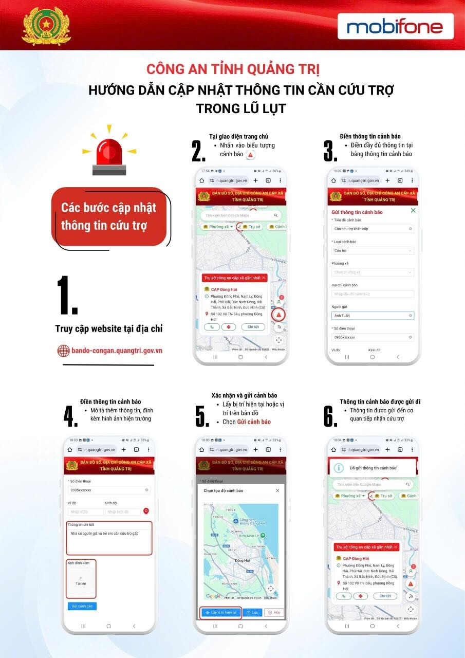
In particular, the digital map also updates security, natural disaster and relief warnings. When an incident occurs, people can send requests for assistance directly on the map with a precisely positioned location. This helps functional forces receive a lot of information at the same time, optimize the coordination of forces and vehicles and shorten response time.
In the context of natural disasters, floods, and unexpected incidents developing complicatedly, this feature is of great significance, helping to improve the effectiveness of command and operation, and at the same time creating conditions for the community to participate in supporting victims.
For the commune-level police force, digital maps are an important tool to grasp the local situation in real time, connect centralized data, proactively process information, and reduce delays in receiving and resolving cases related to security and order.
According to Mr. Phan Thanh Hoai - Director of MobiFone Quang Tri, the coordination with Quang Tri Provincial Police to operate the commune-level digital map system originates from practical requirements after merging wards and communes.
Many localities have larger areas, changes in headquarters, and increased travel distances for people, so they need a tool to support quick and accurate search and connection.
The digital map system integrates many utilities, not only helping people access information easily but also supporting the police force to manage the area more effectively. In the coming time, we will continue to research and apply AI technology to digital maps to increase interaction, support people to look up information and guide administrative procedures faster" - Mr. Hoai said.


