Storm No. 5 moves slowly in the next 24 hours
Latest update from the National Center for Hydro-Meteorological Forecasting, at 4:00 a.m. on October 1, the center of storm No. 5 was at about 20.6 degrees north latitude; 119.8 degrees east longitude, in the northeastern sea of the North East Sea area.
The strongest wind near the storm center is level 16 (184-201km/h), gusting over level 17. The storm moves west-northwest at a speed of about 5km/h.
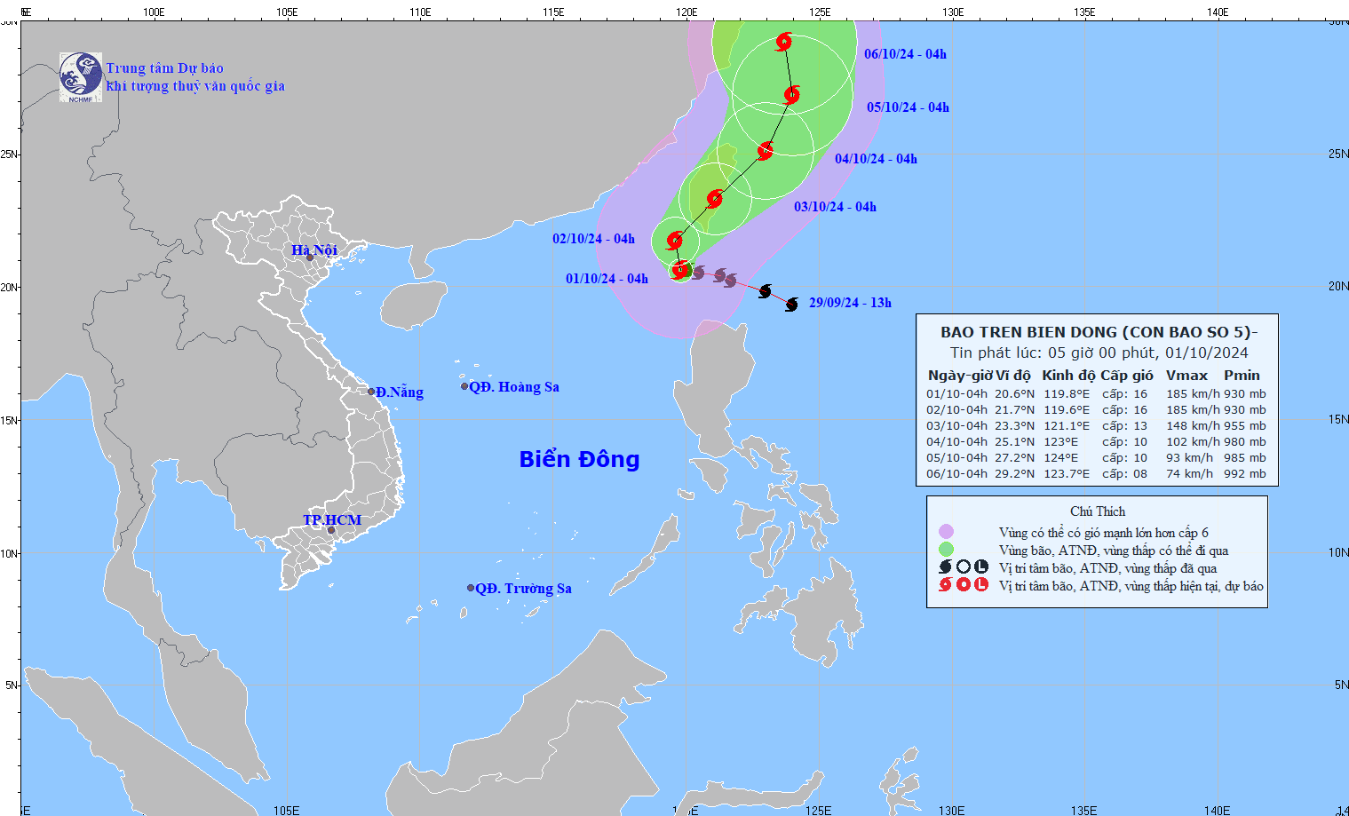
It is forecasted that in the next 24 hours, storm No. 5 will move northwest at a speed of about 5km/h. At 4:00 a.m. on October 2, the center of the storm will be at about 21.7 degrees north latitude - 119.6 degrees east longitude; in the northeastern sea area of the North East Sea.
The strongest wind near the storm center is level 16, gusting over level 17.
It is forecasted that in the next 48 hours, storm No. 5 will move northeast at a speed of about 10km/h, gradually weakening in intensity. At 4:00 a.m. on October 3, the center of the storm will be at about 23.3 degrees north latitude - 121.1 degrees east longitude; on Taiwan Island (China).
The strongest wind near the storm center is level 13, gusting to level 16.
Storm No. 5 causes 7-9m high waves
It is forecasted that in the next 72 hours, the storm will move northeast at a speed of 10 - 15 km/h, weakening further. At 4:00 a.m. on October 4, the center of the storm will be at about 25.1 degrees north latitude - 123 degrees east longitude; in the sea northeast of Taiwan (China).
The strongest wind near the storm center is level 10, gusting to level 12.
From the next 72 to 120 hours, the storm moved mainly in the north-northeast direction, about 10km per hour, and continued to weaken.
Regarding the impact of the storm, at sea, the northeastern sea area of the North East Sea (north of latitude 18; east of longitude 116.5) has strong winds of level 10 - 13, near the storm center level 14 - 16, gusts above level 17, waves 7 - 9m high; rough seas.
Ships operating in the above mentioned dangerous areas are likely to be affected by storms, whirlwinds, strong winds and large waves.