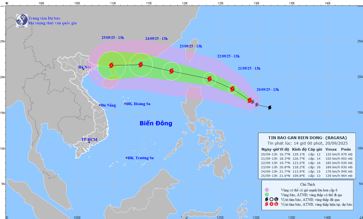
According to the National Center for Hydro-Meteorological Forecasting, at 1:00 p.m. on September 20, the center of Typhoon Ragasa was at about 16.7 degrees north latitude, 129.1 degrees east longitude, about 730km east of Luzon Island (Philippines). The strongest wind near the storm center is level 12 (118 - 133km/h), gusting to level 15. The storm is moving west-northwest at a speed of about 5 - 10km/h.
It is forecasted that in the next 24 hours, the storm will move west-northwest, at a speed of 10 - 15km/h, with the possibility of strengthening.
At 1:00 p.m. on September 21, the center of the storm was at about 18.3 degrees north latitude, 126.7 degrees east longitude, about 490km east-northeast of Luzon Island (Philippines). The storm intensity is level 13 - 14, gusting over level 17.
It is forecasted that in the next 48 hours, the storm will continue to move west-northwest, at a speed of 15-20km/h and will continue to strengthen.
At 1:00 p.m. on September 22, the center of the storm was at about 19.7 degrees north latitude, 123.5 degrees east longitude, about 220km north-northeast of Luzon Island (Philippines). The storm intensity is level 15 - 16, gusting over level 17.
It is forecasted that in the next 72 hours, the storm will continue to move west-northwest, at a speed of 20 - 25km/h and enter the East Sea.
At 1:00 p.m. on September 23, the center of the storm was at about 20.8 degrees north latitude, 118.2 degrees east longitude, in the northeastern sea area of the northern East Sea. The storm intensity is level 15 - 16, gusting over level 17.
The danger zone in the next 72 hours will be north of latitude 17 degrees north and east of longitude 116 degrees east. The natural disaster risk level is level 4 for the eastern sea area of the northern East Sea.
Warning from the next 72 to 120 hours, the storm will move mainly westward, traveling about 20km per hour, gradually weakening in intensity.
Forecast of the impact of the storm, from the afternoon of September 22, the sea area east of the northern East Sea will have strong winds of level 6 - 7, then increase to level 8 - 9, gusting to level 11.
From the night of September 22, the wind will increase to level 10 - 13, the area near the storm's eye will have level 14 - 16, gusting over level 17. Waves are 4 - 8m high, near the center of the storm over 10m, the sea is rough. Ship operating in the above-mentioned dangerous area are likely to be affected by thunderstorms, whirlwinds, strong winds and large waves.