Although it is only the beginning of the season, storm No. 1 has caused great impacts. The National Center for Hydro-Meteorological Forecasting has re-evaluated the development and nature of this storm.

Rainfall due to storm No. 1 far exceeds records
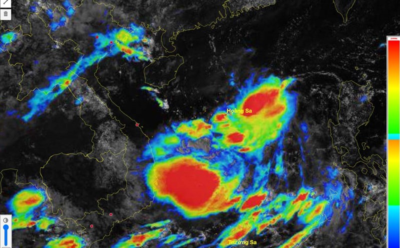
Previously, in the early morning of June 10, a low pressure area in the North East Sea area strengthened into a tropical depression. On the morning of June 11, the tropical depression strengthened into storm No. 1 (international name Wutip).
According to Mr. Mai Van Khiem - Director of the National Center for Hydro-Meteorological Forecasting, the natural disaster from June 10 to 14, 2025 due to the impact of storm No. 1 is of a special, unusual and extreme nature, rare in the history of hydrometeorology in the Central region.
"This is the first storm in the East Sea to appear in June in more than 40 years, and is also the first storm to cause particularly heavy rain in the Central Central region in June since 1952, with rainfall far exceeding previous records" - Mr. Mai Van Khiem said.
According to data from the meteorological agency, very heavy to extremely heavy rain occurred over a wide area from South Ha Tinh to Quang Nam, with total rainfall ranging from 250 - 550mm, in many places over 800mm, especially Bach Ma station (Hue) reached 1203mm/3 days - the highest in history in June, surpassing the record of 410mm/1 day in the Southeast in 1999.
"More abnormally, there were 32 stations recording 6 hours of rain exceeding 200mm, of which Loc Tri station (Thua Thien Hue) recorded up to 319.4mm in 6 hours - an extreme level rarely seen in the June data series" - Mr. Khiem said.
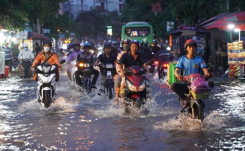
The storm's circulation caused an early and unusual major flood. The flood from June 11 to 14 on rivers from South Quang Binh to Quang Nam is considered historic and unusual in the same period in the observation data series.
According to statistics, the flood peak on Kien Giang River at Kien Giang Station, Thach Han River at Thach Han, Bo River at Phu Oc and Vu Gia River at Ai Nghia is the highest flood peak in the past 30 years in the same period in June.
"This natural disaster shows the seasonal shift and extreme weather of the climate, unusual and no longer regulated" - Mr. Mai Van Khiem commented.
The risk of strong storms appearing in 2025 cannot be ruled out
As of 6:00 a.m. on June 16, according to reports from Nghe An, Ha Tinh, Quang Binh, Quang Tri, Hue, Da Nang, Quang Nam provinces/cities, storm No. 1 and rain and floods have caused serious damage.
The flood killed 9 people (4 in Quang Binh, 3 in Quang Tri, 2 in Hue). Floods also caused 5 houses to collapse in Quang Nam; 94 houses were damaged, roofs blown off (Ha Tinh 27, Hue 61, Quang Nam 1, Quang Tri 5).
Regarding agriculture, 59,988 hectares of rice and crops were flooded (426 hectares in Nghe An, 13,436 hectares in Quang Binh, 25,372 hectares in Quang Tri, 18,853 hectares in Hue, 1,901 hectares in Da Nang).
Regarding seafood, 2,341 hectares of aquaculture were damaged by flooding and drift (Quang Binh 1,636ha, Quang Tri 623ha, Da Nang 33ha, Quang Nam 49ha); 324 cages were damaged (Quang Binh 265, Quang Tri 59). The storm also caused 8 ships (Quang Binh 3, Da Nang 5) to sink and be damaged.
According to Mr. Mai Van Khiem, the forecast for the number of storms/tropical depressions in 2025 is likely to be approximately the average of many years (ie about 11 - 13 storms/tropical depressions in the East Sea, affecting the mainland about 5 - 6 storms).
"We also do not rule out the possibility of strong and very strong storms (ie winds above level 12) appearing this year. Especially in the context of the impact of climate change, many adverse factors cause storm activities to increase more suddenly and frequently" - Mr. Khiem analyzed.