Today, June 13, storm No. 1 has strengthened to level 11, gusting to level 14 and continues to show signs of strengthening. The information on the forecast for the next developments of the storm was updated by Dr. Hoang Phuc Lam - Deputy Director of the National Center for Hydro-Meteorological Forecasting - late this afternoon.

Sir, when is the forecast for storm No. 1 to strengthen and how will it develop further?
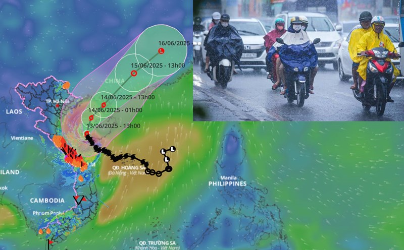
- In recent hours, storm No. 1 has moved quite slowly. Storm No. 1 will continue to strengthen, the intensity may reach level 12 tonight and tonight, June 13. At 4:00 p.m. on June 13, the center of the storm was at about 18.9 degrees north latitude; 108.3 degrees east longitude, in the sea east of the Gulf of Tonkin, about 215km south-southeast of Bach Long Vi Island. The strongest wind near the storm center is level 11 (103-117km/h), gusting to level 14.
It is forecasted that in the next 12 hours, the storm will move north-northeast and then likely increase in intensity to level 11 - 12, gusting to level 14 - 15. The storm will then continue to move north-northeast into the Lusi Peninsula (China) and gradually weaken.
Thus, the center of storm No. 1 has remained in the Gulf of Tonkin for quite a while. So what are the notable impacts at sea and how do you recommend coastal residents?
- Ship operating in the Gulf of Tonkin, the offshore waters from Quang Tri to Da Nang and the northwest of the East Sea should avoid going to sea because they are likely to be affected by strong winds of level 7 - 9, the area near the storm's eye will have levels 10 - 12, gusts of level 14, waves 4 - 6m high, and rough seas. In addition, there is a possibility of being affected by thunderstorms, whirlwinds, strong winds, and large waves.
The Gulf of Tonkin (including Co To and Bach Long Vi island districts) has waves 2 - 4m high, especially 4 - 6m east, the sea is very rough.
Northwest of the North East Sea and the offshore waters from Quang Tri to Da Nang will have waves 3 - 5m high, near the storm's eye 4 - 6m, the sea will be very rough.
Hai Phong - Nghe An sea area is likely to have high sea levels ( Hon Dau 3.9m, Hon Ngu 2.8m) causing local flooding in some low-lying areas along the coast and river mouths from 17-19 on June 13.
So on land, when will the heavy rain due to storm No. 1 in the Central region gradually decrease, sir?
- Due to the influence of the western edge of the circulation of storm No. 1, in the afternoon and night of June 13, the area from Quang Binh to Hue will have heavy to very heavy rain with common rainfall of 30 - 70mm, some places over 120mm.
The South of Nghe An and Ha Tinh will have moderate rain, heavy rain, locally very heavy rain and thunderstorms with common rainfall of 20 - 40mm, some places over 100mm.
The coastal areas of Quang Ninh - Hai Phong have strong winds of level 6 - 7, gusting to level 8 - 9; the coastal areas of Thai Binh - Nam Dinh have strong winds of level 5, some places have level 6, gusting to level 7 - 8.
It is predicted that from tonight, the rain in the Central region will gradually decrease and from tomorrow, June 14, the rain will decrease significantly.
Sincerely thank you!