The latest update from the National Center for Hydro-Meteorological Forecasting, due to the influence of storm No. 1, the Gulf of Tonkin has strong winds of level 6 - 7, gusting to level 8 - 9; Con Co recorded strong winds of level 7, gusting to level 8.
Storm is active in the next 12 hours
At 1:00 p.m. on June 13, the center of the storm was at about 18.7 degrees north latitude; 108.4 degrees east longitude, in the sea east of the Gulf of Tonkin, about 235km south-southeast of Bach Long Vi Island. The strongest wind near the storm center is level 11 (103 - 117km/h), gusting to level 14. The storm is moving north at a speed of 10 - 15km/h.
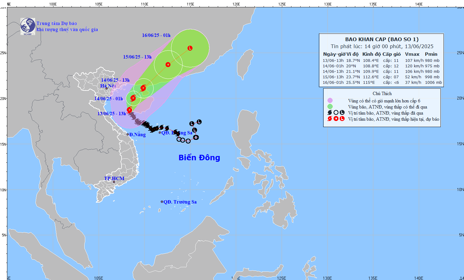
It is forecasted that in the next 12 hours, the storm will move north-northeast at a speed of 10 - 15km/h. At 1:00 a.m. on June 14, the center of the storm was at about 20 degrees north latitude; 108.8 degrees east longitude, in the eastern area of the northern Gulf of Tonkin.
The strongest wind near the storm center is level 11 - 12, gusting to level 14. The dangerous area is located north of the latitude of 16.5 degrees north; from 106.5 to 111.5 degrees east. The natural disaster risk level is level 3 in the Gulf of Tonkin sea area, the sea off the coast from Quang Tri to Da Nang and the northwest of the northern East Sea.
It is forecasted that in the next 24 hours, the storm will continue to move north-northeast at a speed of 10 - 15km/h. At 1:00 p.m. on June 14, the center of the storm was at about 21.1 degrees north latitude; 109.9 degrees east longitude, in the Lusi Peninsula (China).
The strongest wind near the storm center is level 11, gusting to level 13. The dangerous area is north of latitude 17.0 degrees north; from 106.5 to 111.5 degrees east. The natural disaster risk level is level 3 in the Gulf of Tonkin, the offshore waters from Quang Tri to Da Nang and the northwest of the northern East Sea.
It is forecasted that in the next 48 hours, the storm will move northeast at a speed of 15 - 20km/h and gradually weaken into a tropical depression. At 1:00 p.m. on June 15, the center of the tropical depression was at about 23.7 degrees north latitude; 112.6 degrees east longitude, in the southwest area of Guangdong province (China).
The strongest wind near the center of the tropical depression is level 7, gusting to level 9. The danger zone is from the north of the latitude of 18.5 degrees north; from 106.5 to 113.0 degrees east. The natural disaster risk level is level 3 in the northern sea area of the Gulf of Tonkin and the northwest of the northern East Sea.
It is forecasted that in the next 60 hours, the tropical depression will continue to move northeast at a speed of 20 - 25km/h and weaken into a low pressure area in the southern mainland of China. At 1:00 a.m. on June 16, the center of the low pressure area was at about 25.5 degrees north latitude; 115 degrees east longitude; intensity below level 6.
Storm circulation rain continues this afternoon and tonight
Regarding the impact of the storm at sea, the Gulf of Tonkin sea area (including Co To and Bach Long Vi island districts) has strong winds of level 7 - 9, near the storm's eye level 10 - 12, gusting to level 14. Waves are 2 - 4m high, in the east they can be 5 - 7m high, the sea is very rough.
The northwest of the northern East Sea and the offshore waters from Quang Tri to Da Nang will have strong winds of level 6 - 8, near the storm center level 9 - 11, gusts of level 14, waves 3 - 5m high, near the storm center there will be waves 4 - 6m high, the sea will be very rough.
Ship operating in dangerous areas are likely to be affected by thunderstorms, whirlwinds, strong winds and large waves.
In coastal waters, due to the influence of high tides combined with storm surges, the waters from Hai Phong to Nghe An are likely to experience high sea levels ( Hon Dau: 3.9m; Hon Ngu: 2.8m), causing local flooding in some low-lying areas and river mouths from 5:00 p.m. to 7:00 p.m. on June 13.
On land, coastal areas from Quang Ninh to Hai Phong will have strong winds of level 6 - 7, gusting to level 8 - 9; coastal areas of Thai Binh and Nam Dinh will have strong winds of level 5, some places will have level 6, gusting to level 7 - 8.
In the afternoon and night of June 13, the area from Quang Binh to Hue will have heavy to very heavy rain with common rainfall from 30 - 70mm, some places over 120mm.
The southern Nghe An and Ha Tinh areas will have moderate rain, heavy rain, locally very heavy rain and thunderstorms with common rainfall from 20 - 40mm, some places over 100mm.


