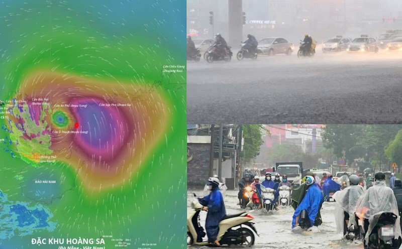
Latest update from the National Center for Hydro-Meteorological Forecasting, at 4:00 p.m. on October 5, the center of the storm was at about 20.9 degrees north latitude; 110.0 degrees east longitude, in the Lusi Peninsula (China), about 230 km east-southeast of Mong Cai (Quang Ninh). The strongest wind near the storm center is level 12 (118-133 km/h), gusting to level 15. The storm is moving west-northwest at a speed of 20-25 km/h.
The storm enters the mainland and drops to level 8-9
It is forecasted that in the next 12 hours, the storm will move west-northwest at a speed of 20-25 km/h, tending to weaken gradually. At 4:00 a.m. on October 6, the center of the storm was at about 21.9 degrees north latitude; 107.8 degrees east longitude, in the mainland of Guangxi province (China). The wind intensity decreased to level 8-9, gusting to level 11.
The dangerous area in the East Sea during this period is the northern latitude of 18.5 degrees north and the west of 112.5 degrees east. Level 3 natural disaster risk, affecting the northwestern sea area of the northern East Sea, the northern area of the Gulf of Tonkin, the mainland along the coast from Quang Ninh to Hung Yen, Lang Son province and the east of Cao Bang province.
It is forecasted that in the next 24 hours, the storm will continue to move west-northwest at a speed of about 20 km/h, moving deep into the mainland and gradually weakening. At 4:00 p.m. on October 6, the center of the remaining low pressure area was at about 22.7 degrees north latitude; 105.5 degrees east longitude, in the northern mountainous area. The storm weakens into a low pressure area (with winds below level6).
The danger zone is the area north of the latitude of 20 degrees north and west of the longitude of 109.5 degrees east. The natural disaster risk level is still at level 3, affecting the northern area of the Gulf of Tonkin, the coastal mainland from Quang Ninh to Hung Yen, Lang Son province and the east of Cao Bang province.
The northeast of Quang Ninh province is the strongest wind zone
Regarding the impact of the storm at sea, the northwestern sea area of the North East Sea will have strong winds of level 8-9, near the center of the storm level 10-11, gusts of level4; waves 4-6m high, near the center of the storm level 5-7m, rough seas, extremely powerful destructive power, extremely strong waves, which can sink ships with great weight.
The northern area of the Gulf of Tonkin (including the special areas of Bach Long Vi, Van Don, Co To, Cat Hai and Hon Dau island) will have strong winds of level 6-7, then increase to level 8-9, near the storm's eye level 10-12, gusts of level 15. waves 2.0-4.0 m high, near the storm's eye 3.0-5.0 m, rough seas, very dangerous for ships and boats.
Storm surge in coastal areas and islands in Quang Ninh - Hai Phong province is 0.4-0.6 m high. Flooding warning in low-lying areas, coastal areas, river mouths due to rising water and big waves from the afternoon and evening of October 5.
The weather at sea and in coastal areas during the storm is extremely dangerous and unsafe for any vehicle or structure operating in the dangerous area such as tourist boats, passenger ships, transport ships, cages, aquaculture areas, dykes, embankments, coastal roads. Vehicles are likely to overturn or be destroyed; flooded due to strong winds, large waves and rising sea levels.
On land, from the night of October 5 to noon of October 6, the coastal mainland area from Quang Ninh to Hung Yen and Lang Son province will have winds gradually increasing to level 6-7, near the storm's eye level 8-9, gusting to level 11-12, causing tree branches to break, roofs blown off, great property damage, and unable to go back to the wind. The deep inland area east of the Northeast will have strong winds of level 4-5, some places will have level 6, gusting to level 7-8.
Communes and wards in the northeastern area of Quang Ninh province are likely to have strong winds of level 8-9, gusting to level 11-12; the remaining communes and wards of Quang Ninh province and the coastal areas of Hai Phong city have strong winds of level 7-8, gusting to level 10; the coastal areas of Hung Yen province and the northern border of Lang Son province are likely to have strong winds of level 6-7, gusting to level 9; the northeastern area of Bac Ninh province (old Bac Giang province) and the eastern part of Cao Bang province have strong winds of level 6, gusting to level 8.
Regarding heavy rain, from the night of October 5 to the end of the night of October 7, the mountainous and midland areas of the North will have heavy rain, with common rainfall of 150-250 mm, locally very heavy rain over 400 mm. Warning of the risk of heavy rain over 150 mm/3 hours. The Northern Delta and Thanh Hoa have moderate rain, heavy rain, common rainfall of 70-150 mm, locally over 200 mm.
The Hanoi area is less likely to be directly affected by storms, but beware of thunderstorms, tornadoes and strong gusts of wind. From early morning of October 6 to the end of October 7, there will be moderate rain, heavy rain, common rainfall of 70-120 mm, locally over 150 mm.
Due to the influence of a wide storm circulation, it is necessary to be on guard against the risk of thunderstorms, tornadoes and strong gusts of wind both before and during the storm's landfall.