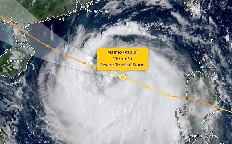
As Typhoon No. 11 Matmo is approaching Quang Ninh, a new tropical storm has appeared in the Northwest Pacific Ocean, named Typhoon Ha Long (Halong).
According to the Joint Typhoon Warning Center (JTWC), tropical depression 28W has strengthened into storm Ha Long since the afternoon of October 4, with a position of 24.8 degrees North latitude, 143.3 degrees East longitude, with the strongest wind of about 55 km/h and central pressure of 1003 hPa.
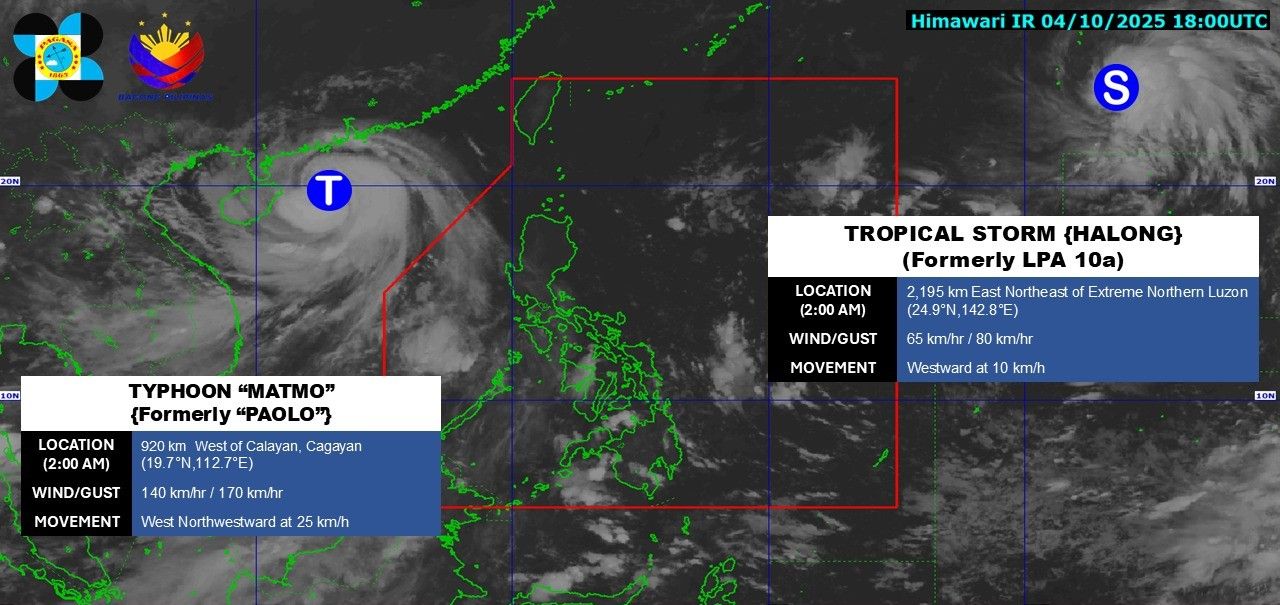
The latest storm information from the Philippine Atmospheric, Geophysical and Astronomical Services Administration (PAGASA) at 2:00 a.m. on October 5, the center of storm Ha Long was at about 24.9 degrees North latitude, 142.9 degrees East longitude, 2,195km East Northeast of Luzon. Maximum winds near the center of the storm are 65 km/h, gusting to 80 km/h. The storm is moving westward at a speed of 10 km/h.
It is forecasted that in the next 24 hours, storm Ha Long will continue to strengthen as it moves west-northwest, towards the waters of Ryukyu Islands and Okinawa (Japan).
Thus, from mid- to late next week (about October 9-10, Ha Long is forecast to reach typhoon level, with the strongest winds reaching 200 km/h, equivalent to level 15-16 on the Beaufort scale.
According to the China Meteorological Administration (CWA), while Typhoon No. 11 Matmo is heading towards Hainan Island (China) and is reducing its impact on Taiwan (China), Typhoon Ha Long may cause widespread rain in northern Taiwan (China) next week.
From October 8, the northeast monsoon due to the far edge of the storm combined with the terrain may cause Co Long, Nghi Lan and the mountainous areas of Taipei to experience moderate to heavy rain. The east coast and southern part of Taiwan (China) may also experience scattered thunderstorms in the afternoon.
Experts say that 2025 could be one of the most active typhoon seasons in the East Sea and Northwest Pacific Ocean over the past decade, with many strong storms appearing consecutively from September to present, including Typhoon No. 11 Matmo, Super Typhoon No. 9 Ragasa and possibly Typhoon Ha Long.
Regarding storm No. 11 Matmo, according to the Vietnam National Center for Hydro-Meteorological Forecasting, at 6:00 a.m. on October 5, the center of the storm was at about 20.0 degrees North latitude; 111.8 degrees East longitude, 90km East Northeast of Hainan Island (China). The strongest wind near the storm center is level 12-13 (118-149 km/h), gusting to level 15. It is forecasted that in the next 3 hours, the storm will move in a West-Northwest direction, at a speed of about 25km/h.
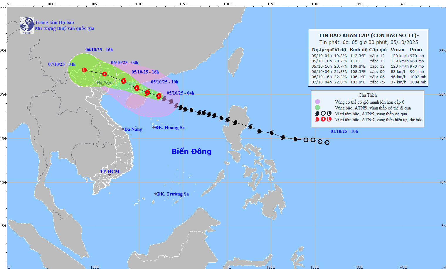
It is forecasted that by 4:00 a.m. on October 6, the center of storm No. 11 will be at 21.5 degrees North latitude, 108.3 degrees East longitude; on the coast of Quang Ninh - Hai Phong province. The storm intensity decreased to level 9, gusting to level 12. The storm is moving west-northwest at about 20 km/h.
At 4:00 p.m. on October 6, the center of the storm was at 22.3 degrees North latitude, 106.1 degrees East longitude; in the northern mountainous areas of the North. The intensity decreased to level 6, gusting to level 8. The storm is moving west-northwest at about 20 km/h.
It is forecasted that by 4:00 a.m. on October 7, the center of the storm will be at 22.8 degrees North latitude, 103.8 degrees East longitude; in the mountainous areas of the Northwest. Storm No. 11 weakens into a low pressure area, with an intensity below level 6, moving in the West Northwest direction, about 20 km/h.