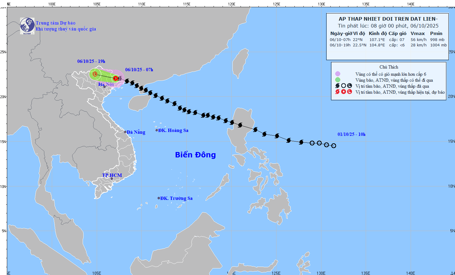
Latest update from the National Center for Hydro-Meteorological Forecasting, at 7:00 a.m. on October 6, the center of the tropical depression was at about 22 degrees north latitude; 107.1 degrees east longitude, in the southern area of Guangxi province (China). The strongest wind near the center of the tropical depression is level 7 (50 - 61 km/h), gusting to level 9. The tropical depression is moving westward at a speed of 20 - 25 km/h.
It is forecasted that in the next 12 hours, the tropical depression will continue to move west-northwest, at a speed of 20 - 25 km/h and gradually weaken into a low pressure area.
At 7:00 p.m. on October 6, the center of the low pressure area was at about 22.5 degrees north latitude; 104.8 degrees east longitude, in the mountainous areas of the North. Wind intensity below level 6.
The danger zone is north of the latitude of 20 degrees north; west of the longitude of 109 degrees east. The natural disaster risk level is level 3 for the northern area of the Gulf of Tonkin, mainland areas of Quang Ninh and Lang Son provinces.

According to Mr. Mai Van Khiem - Director of the National Center for Hydro-Meteorological Forecasting, Department of Hydro-Meteorology, although the storm has weakened, the impact after the storm continues.
At sea, this morning (October 6), the northern area of the Gulf of Tonkin (including the Bach Long Vi special zone) has strong winds of level 6, gusts of level 8; waves 2-3 m high; rough seas, dangerous for operating ships.
"This morning (October 6), the storm is only likely to cause strong winds of level 6, some places with level 7, gusting to level 8 - 9 in the coastal areas of Quang Ninh province, border areas between Lang Son province (Vietnam) and Guangxi (China)" - Mr. Khiem said.
Regarding the development of heavy rain, according to the Director of the Meteorological Agency, from early morning of October 6 to the end of the night of October 7, the mountainous and midland areas of the North will have heavy rain, with common rainfall from 100 - 200mm, locally very heavy rain over 300mm. Warning of the risk of heavy rain (with rainfall greater than 150mm within 3 hours).
The Northern Bang Delta and Thanh Hoa will have moderate rain, heavy rain with common rainfall of 50-150mm, locally very heavy rain over 200mm.
Commenting on the rain in Hanoi, according to Mr. Khiem, storm No. 11 is unlikely to have heavy rain, causing widespread flooding like on September 30, 2025, however, localized flooding can still occur in low-lying areas with slow drainage.
"There was no heavy rain in Hanoi this morning. From noon to night, the circulation after storm No. 11 is likely to cause heavy rain in the Hanoi area with common rainfall from 50 - 100 mm, locally over 150 mm" - Mr. Khiem said.


