In Nghe An, there is a level 15 gusty wind monitoring station
Due to the influence of storm No. 5, at Bach Long Vi station (Hai Phong), there are strong winds of level 7, gusting to level 9; Co To station (Quang Ninh) has strong winds of level 7, gusting to level 10; Hon Ngu station (Nghe An) has strong winds of level 8, gusting to level 11.
The coastal areas of the provinces from Quang Ninh to Thanh Hoa will have strong winds of level 6-8, gusting to level 9. Nghe An - Ha Tinh area has strong winds of level 8-10, gusts of level 12-15, such as Dien Chau station (Nghe An) has strong winds of level 10, gusts of level 12; Do Luong station has gusts of level 15; Vinh station has gusts of level 12; Ky Anh station (Ha Tinh) has strong winds of level 8, gusts of level2; Cam Nhuong station (Ha Tinh) has strong winds of level 10, gusts of level 13.
The storm water rose 1.01m in Sam Son (Thanh Hoa), 1.66m in Hon Ngu (Nghe An), and 0.51m in Vung Ang (Ha Tinh). In the Northern Delta provinces and from Thanh Hoa to Quang Tri, there was moderate rain, heavy rain, and some places had very heavy rain over 550mm.
Storm No. 5 weakens into tropical depression in the next 12 hours
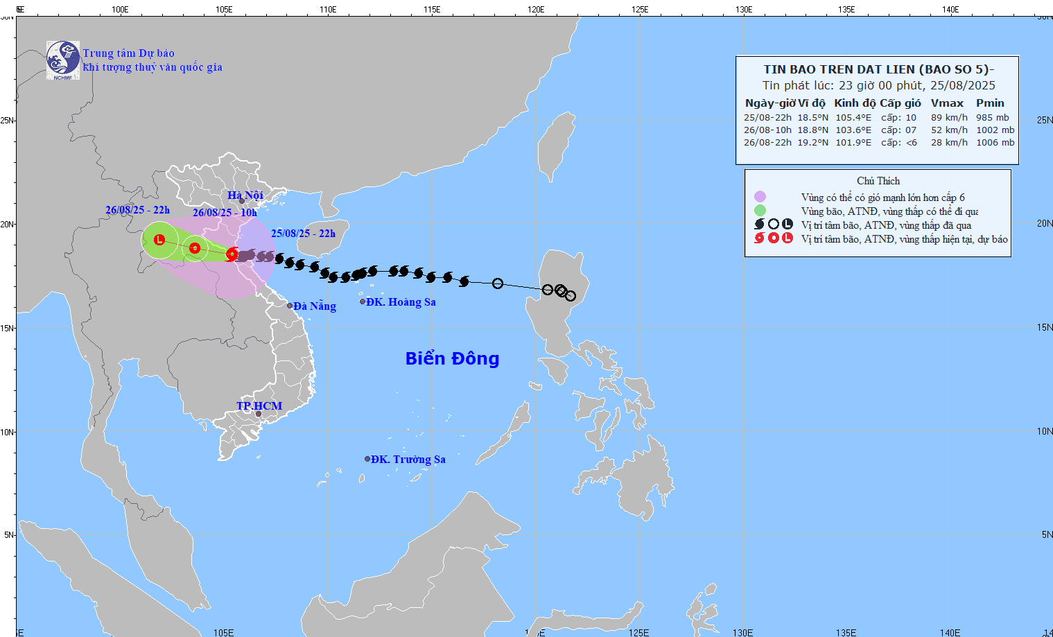
At 10:00 p.m. on August 25, the center of the storm was at about 18.5 degrees north latitude - 105.4 degrees east longitude, on the mainland area of southern Nghe An - northern Ha Tinh. The strongest wind near the storm center is level 9 - 10 (89 - 117km/h), gusting to level 12; moving west-northwest at a speed of about 10km/h.
It is forecasted that in the next 12 hours, the storm will move west-northwest at a speed of about 15km/h and gradually weaken into a tropical depression.
At 10:00 on August 26, the center of the tropical depression was at about 18.8 degrees north latitude - 103.6 degrees east longitude, in the Central Laos area. The strongest wind is level 7, gusting to level 9. The danger zone is from 17.0 to 20.5 degrees north latitude, west of 109.0 degrees east longitude.
Level 3 natural disaster risk, the affected area is the northern Gulf of Tonkin (including Bach Long Vi special zone) and the sea area from Thanh Hoa to Quang Tri (including Hon Ngu island).
It is forecasted that in the next 24 hours, the tropical depression will continue to move west-northwest at a speed of about 15km/h.
At 10:00 p.m. on August 26, the center of the tropical depression was at about 19.2 degrees north latitude - 101.9 degrees east longitude, in the Central Laos area. The strongest wind is below level 6.
Next impacts of the storm
At sea, the sea area from Thanh Hoa to Quang Tri (including Hon Ngu island, Con Co special area) has strong winds of level 7-9, gusts of level 12, waves 3-5m high, very rough seas. The Gulf of Tonkin (including the special areas of Bach Long Vi, Cat Hai, Co To, Van Don) will have strong winds of level 6-7, gusts of level 9, waves 2-4m high, rough seas. The water level in the coastal provinces from Thanh Hoa to Ha Tinh has peaked and is slowly decreasing following the tidal cycle.
On land, the southern Thanh Hoa - northern Ha Tinh area has strong winds of level 7-8, the area near the storm center has level 9-10, gusting to level 12; the northern Thanh Hoa, southern Ha Tinh and coastal areas of the provinces from Quang Ninh to Ninh Binh have strong winds of level 6-7, gusting to level 8-9. The level of impact according to the wind level of the storm is detailed in Appendix 1.
Regarding heavy rain, from the night of August 25 to the end of August 26, in the midlands and deltas of the North, Lao Cai, Son La and from Thanh Hoa to northern Quang Tri, there will be widespread heavy rain, with common rainfall of 50-100mm, some places over 200mm. In particular, Ninh Binh and from Thanh Hoa to Ha Tinh will have heavy to very heavy rain, with common rainfall of 100-200mm, some places over 400mm. Warning of the risk of heavy rain over 150mm/3 hours.
From the night of August 25-26, the capital Hanoi will have moderate rain, heavy rain and thunderstorms; Da Nang City will have occasional showers; Ho Chi Minh City will have rain, showers and thunderstorms (concentrated in the afternoon and evening). During thunderstorms, it is necessary to be on guard against the risk of tornadoes and strong gusts of wind.
From the night of August 25-27, the upper and middle areas of Laos will have heavy rain, with common rainfall of 100-250mm, in some places in central Laos over 500mm.