Warning of 2 provinces of heavy to very heavy rain, dangerous weather in the next 6 hours

AN AN |

The meteorological agency has warned of the risk of flash floods and landslides due to continued heavy rain in Thanh Hoa and Nghe An provinces.

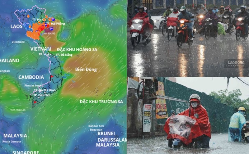
According to the National Center for Hydro-Meteorological Forecasting, in the past 18 hours (from 4:00 p.m. on July 21 to 10:00 a.m. on July 22), the Thanh Hoa and Nghe An provinces have had moderate rain, heavy rain, locally very heavy rain such as Trieu Son 218.6mm, Thach Quang 203.6mm (Thanh Hoa); Tay Hieu (Nghe An) 157.6mm...

Soil moisture models show that some areas in the above provinces are nearly saturated (over 85%) or have reached a saturated state.

Warning in the next 3 - 6 hours (from 10:20 on July 22), the above provinces will continue to have rain with common accumulated rainfall from 50 - 100mm, some places over 200mm.

Warning in the next 6 hours (from 10:20 on July 22), there is a risk of flash floods on small rivers and streams, landslides on steep slopes in many communes/wards.

Cap nhat danh sach cac khu vuc co nguy co se xay ra lu quet, sat lo dat da trong 6 gio toi (tinh tu 10 gio 20 phut ngay 22.7). Nguon: Trung tam Du bao Khi tuong Thuy van Quoc gia
Update on the list of areas at risk of flash floods and landslides in the next 6 hours (from 10:20 on July 22). Source: National Center for Hydro-Meteorological Forecasting

The meteorological agency warns that the risk of natural disasters due to flash floods, landslides, and land subsidence due to heavy rain or water flow is level 1.

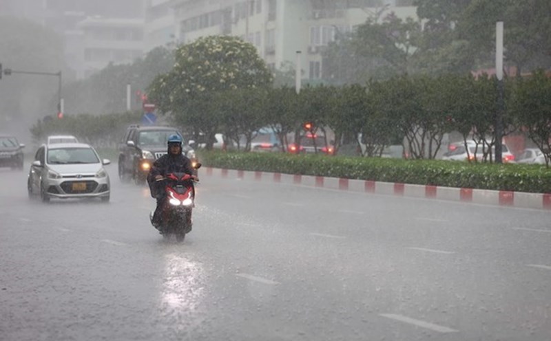
Flash floods and landslides can have a very negative impact on the environment, threatening people's lives; causing local traffic congestion, affecting the movement of vehicles; civil and economic works, causing damage to production activities and socio-economic activities.

The meteorological agency recommends that local authorities pay attention to reviewing bottlenecks and vulnerable locations in the area to take preventive and response measures.

Regarding the hydrological situation, the water level on rivers in the Red - Thai Binh river system, Ma river (Thanh Hoa), Ca river (Nghe An) fluctuates and is below alert level 1.

From now (July 22) to July 25, on rivers in the North, Thanh Hoa, Nghe An, a flood will occur, with a flood amplitude on rivers from 3 - 5m. During this flood, the flood peak on small rivers, upstream of Thao River, Lo River, Thai Binh River, Hoang Long River, upstream of Ma River, Ca River will rise to alert level 1 - alert level 2; the flood peak downstream of Red River, Ma River, Ca River will be below alert level 1.

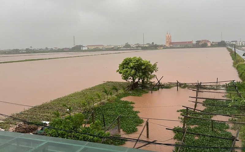
There is a high risk of flooding in low-lying areas along rivers, urban areas in the Northern Delta, Thanh Hoa, Nghe An; flash floods and landslides on steep slopes in the mountainous areas of the North, Thanh Hoa, Nghe An.

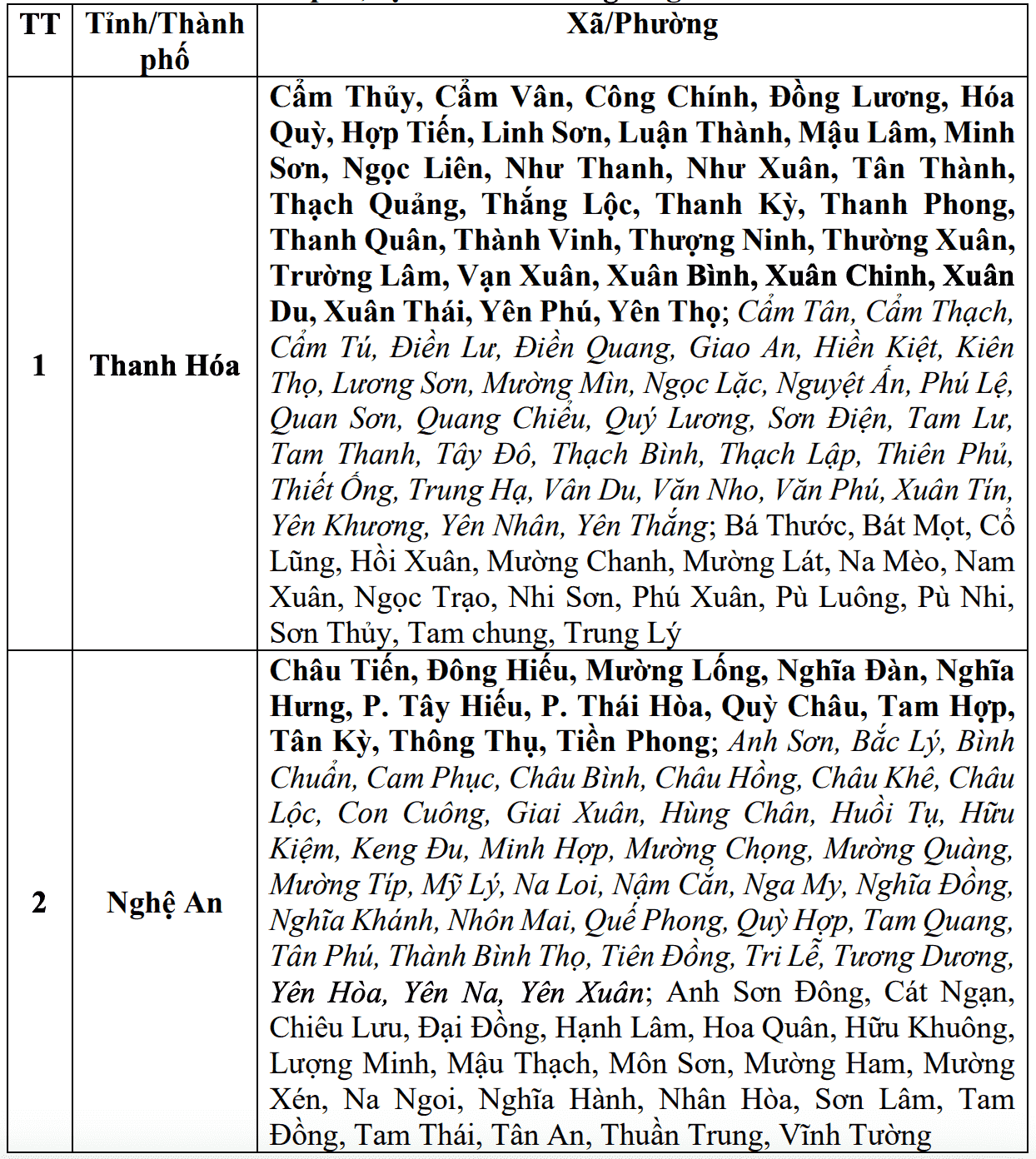
Real-time warning information for areas at risk of flash floods and landslides is provided online on the website of the Department of Hydrometeorology at: https://luquetsatlo.nchmf.gov.vn and in a separate bulletin warning of flash floods and landslides. The warning level of natural disaster risk due to floods is level 1.

Floods on rivers and streams can cause flooding in low-lying areas along rivers, affecting activities such as waterway transportation, aquaculture, agricultural production, people's livelihood and socio-economic activities.

AN AN
TIN LIÊN QUAN

Storm No. 3 Wipha makes landfall, forecast of heavy rain and strong winds in Hanoi today

|

According to the Northern Meteorological Agency, due to the impact of storm No. 3 Wipha, Hanoi may have gusts of level 8 in the south and center of the city.

Winds begin to blow strongly along the coast of Thanh Hoa

|

From 9:00 a.m. on July 22, recorded directly in the coastal area of Thanh Hoa, the wind began to blow strongly, people proactively took precautions to avoid storm No. 3.

Storm No. 3 Wipha has reached the coast of Hai Phong - Ninh Binh, gusting to level 12

|

According to the meteorological agency, when entering the coastal waters of Hai Phong - Ninh Binh, the strongest wind near the center of storm No. 3 Wipha will be level 9, gusting to level 12.

Identifying the male body drifting in Ha Long Bay on the morning of July 22

|

Quang Ninh - This male body was identified as one of the victims of the sinking of the Green Bay tourist boat 58, license plate QN-7105 on July 19.

High-rise house fire on Giai Phong Street, Hanoi

|

Hanoi - A high-rise house on Giai Phong Street suddenly caught fire fiercely on the afternoon of July 22. The authorities quickly arrived at the scene to put out the fire.

Hung Yen recovers after storm, people start taking to the streets, many trees fall

|

Hung Yen - On the afternoon of July 22, the weather in some wards such as Pho Hien, Nam Son, Hong Chau stabilized again after storm No. 3.

65,000 hectares of rice in Ninh Binh submerged in water

|

Ninh Binh - The whole province has about 74,017 hectares of rice fields affected by storm No. 3, of which the area of white flooding is 65,489 hectares.

To propose salary increase as a driving force for development

|

Mr. Le Dinh Quang - Former member of the National Wage Council shared in depth and frankly about the proposals to adjust the regional minimum wage in the coming time.

Storm No. 3 Wipha makes landfall, forecast of heavy rain and strong winds in Hanoi today

AN AN |

According to the Northern Meteorological Agency, due to the impact of storm No. 3 Wipha, Hanoi may have gusts of level 8 in the south and center of the city.

Winds begin to blow strongly along the coast of Thanh Hoa

Quách Du |

From 9:00 a.m. on July 22, recorded directly in the coastal area of Thanh Hoa, the wind began to blow strongly, people proactively took precautions to avoid storm No. 3.

Storm No. 3 Wipha has reached the coast of Hai Phong - Ninh Binh, gusting to level 12

AN AN |

According to the meteorological agency, when entering the coastal waters of Hai Phong - Ninh Binh, the strongest wind near the center of storm No. 3 Wipha will be level 9, gusting to level 12.