Warning of heavy rain in 9 provinces, risk of bad weather in the next 6 hours

AN AN |

The meteorological agency warns that many provinces in the midlands and mountainous areas of the Northern region will have heavy rain; risk of flash floods and landslides in some communes and wards.

Updated bulletin issued at 8:30 am on August 6 from the National Center for Hydro-Meteorological Forecasting, in the past 24 hours (from 8:00 am on August 5 to 8:00 am on August 6), the Northern provinces and Thanh Hoa provinces have had moderate to heavy rain, with very heavy rain in some places such as Muong Than 60.6mm observation station (Lai Chau); Na Son 2 63.2mm (Dien Bien); Bon Phang 139.2mm (Son La); Ngoc Son Management Board 139mm (Phu Tho); Cam Nhan 115.2mm (Lao Cai); Thuong Giap 118.2mm (Tuyen Quang); Ban Thi 81.4mm (Thai Nguyen); Co To 105.6mm (Quang Ninh); Phu Son 138.4mm (Thanh Hoa);...

The soil moisture model shows that some areas in the above provinces have been near saturation (over 85%) or reached saturation status.

Warning in the next 6 hours, the Northern provinces will continue to have rain with accumulated rainfall commonly in Son La, Phu Tho, Thai Nguyen, Quang Ninh from 20 - 40mm, in some places over 60mm; in Lai Chau, Dien Bien, Lao Cai, Tuyen Quang from 10 - 20mm, in some places over 40mm; in Thanh Hoa from 20 - 50mm, in some places over 70mm.

Risk of flash floods on small rivers and streams, landslides on slopes in many communes/wards.
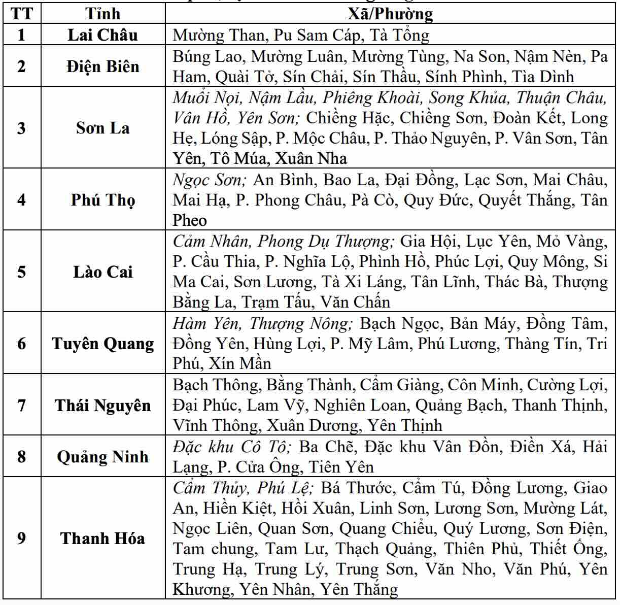
Danh sách các khu vực có nguy cơ xảy ra lũ quét, sạt lở đất đá trong 6 giờ tới (tính từ 8h30 ngày 6.8). Nguồn: Trung tâm Dự báo Khí tượng Thủy văn Quốc gia
List of areas at risk of flash floods and landslides in the next 6 hours (as of 8:30 am on August 6). Source: National Center for Hydro-Meteorological Forecasting

Warning level of natural disaster risk due to flash floods, landslides, subsidence due to rain, floods or currents is level 1.

Flash floods and landslides can have very negative impacts on the environment, causing local traffic congestion, affecting the movement of vehicles; civil and economic works causing damage to production activities and socio-economic activities.

The meteorological agency recommends that functional agencies in localities pay attention to reviewing flow bottlenecks and key locations in the area to have preventive and response measures.

AN AN
RELATED NEWS

Forecast for the North to continue to have heavy rain from now until morning of August 7, with some places over 200mm

|

Forecast from the evening of August 5 to the morning of August 7, the North and North Central regions will have moderate rain, heavy rain and thunderstorms, locally very heavy rain over 200mm.

Storm No. 3 still has gusts of level 10 moving slowly, forecast route for the next 24 hours

|

Forecast for the next 12 hours, storm No. 3 will move in the East-Northeast direction at a speed of 10-15 km/h and gradually weaken into a tropical depression.

Storm No. 3 gusts at level 10, forecast of dangerous areas in the next 24 hours

|

The dangerous area due to storm No. 3 in the next 24 hours is the southeast sea area of the Northern East Sea.

Many ways to "transform" boarding houses to increase prices before the new school year

|

Hanoi - At the beginning of August, the rented room and mini-apartment market in the Capital became busier, and prices also began to tend to increase.

People discovered steps of an ancient well when planting trees at a cultural house in Hanoi

|

Hanoi - People accidentally discovered the steps of an ancient well when digging a planting pit in the cultural house grounds.

Proposal to finalize the deadline for arranging the apparatus when establishing Quang Ninh and Bac Ninh cities

|

National Assembly deputies proposed to supplement the deadline for completing the arrangement of the apparatus when establishing Quang Ninh and Bac Ninh cities, avoiding delays in handling redundant headquarters and assets.

Forecast for the North to continue to have heavy rain from now until morning of August 7, with some places over 200mm

AN AN |

Forecast from the evening of August 5 to the morning of August 7, the North and North Central regions will have moderate rain, heavy rain and thunderstorms, locally very heavy rain over 200mm.

Storm No. 3 still has gusts of level 10 moving slowly, forecast route for the next 24 hours

AN AN |

Forecast for the next 12 hours, storm No. 3 will move in the East-Northeast direction at a speed of 10-15 km/h and gradually weaken into a tropical depression.

Storm No. 3 gusts at level 10, forecast of dangerous areas in the next 24 hours

AN AN |

The dangerous area due to storm No. 3 in the next 24 hours is the southeast sea area of the Northern East Sea.
