According to the Central Hydrometeorological Station, satellite clouds and lightning positioning show that convective clouds are developing strongly in many communes and wards in the mountainous areas west of the city and expanding to the center of Da Nang and Hoang Sa. The possibility of showers, thunderstorms, tornadoes, lightning, and strong gusts of wind will continue to occur in Da Nang on the evening of September 15.
According to the National Center for Hydro-Meteorological Forecasting, the area from Da Nang to Lam Dong and the South will have scattered showers and thunderstorms, with common rainfall of 15-30mm, some places over 80mm. During thunderstorms, there is a possibility of tornadoes, lightning, hail and strong gusts of wind. The risk of flash floods, landslides on steep slopes and flooding in low-lying areas is warned.
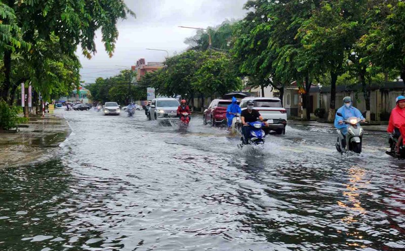
Previously, on the evening of September 14, in Da Nang, heavy rain and prolonged thunder caused many central streets to be partially flooded. From around 5pm, thunderstorms suddenly poured down, heavy rain caused many sections of the road such as Ton Duc Thang, Nguyen Van Tao, Tran Cao Van to be deeply flooded, making it difficult for vehicles to move. Many vehicles stalled, people had to walk through the rising water.
On Tran Cao Van Street, the floodwaters in front of Continuing Education Center No. 2 forced many families to proactively use a barrier in front of the door to avoid water from flooding into their homes.