Latest update from the National Center for Hydro-Meteorological Forecasting, at 7:00 a.m. on October 4, the center of the storm was at about 18.1 degrees north latitude; 116.9 degrees east longitude, in the eastern sea of the northern East Sea, about 530 km east-northeast of the Hoang Sa special zone. The strongest wind near the storm center is level 11 (103 - 117 km/h), gusting to level 14. The storm is moving west-northwest at a speed of about 25 km/h.
In the next 24 hours, the storm will strengthen to 2 levels, then weaken rapidly when it reaches shore
It is forecasted that in the next 24 hours, the storm will move west-northwest at a speed of 20-25 km/h and is likely to strengthen.
At 7:00 a.m. on October 5, the center of the storm was at about 19.9 degrees north latitude; 111.8 degrees east longitude, northwest of the northern East Sea, about 90 km east of the Lusian Peninsula (China). Strong wind level 13, gust level 16.
The danger zone in the next 24 hours will be from latitude 16 to 22 degrees north, longitude 110 to 119 degrees east. Natural disaster risk level 3 for the northern East Sea area.
It is forecasted that in the next 48 hours, the storm will move west-northwest at a speed of about 20 km/h, entering the eastern sea area of the northern Gulf of Tonkin and gradually weakening. At 7:00 a.m. on October 6, the center of the storm was at about 21.8 degrees north latitude; 107.6 degrees east longitude, in the Vietnam - China border area. Strong wind level 8, gust level 10.
The dangerous area in 48 hours will be north of latitude 18 degrees north, east of longitude 114 degrees east. The natural disaster risk level is level 3 for the northern East Sea, the northern sea area of the Gulf of Tonkin and the mainland from Quang Ninh to Ninh Binh.
It is forecasted that in the next 60 hours, the storm will continue to move west-northwest at a speed of 15-20 km/h, entering the mainland northeast of the Northern region and gradually weakening into a tropical depression, then a low pressure area.
At 7:00 p.m. on October 6, the center was at about 22.7 degrees north latitude; 105.7 degrees east longitude, in the mountainous areas of the northern part of the province. Wind intensity below level 6.
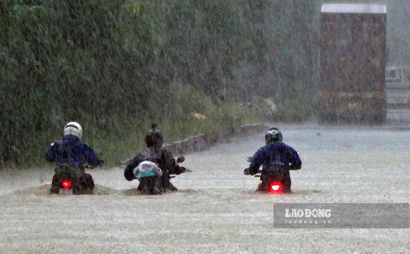
Strong winds from Quang Ninh to Ninh Binh, heavy rain in the North to Nghe An
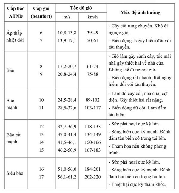
Regarding the impact at sea, the northern East Sea area has strong winds of level 8-10, the area near the storm center has strong winds of level 11-13, gusts of level 16, waves 4-6 m high, the area near the storm center has 6-8 m, the sea is very rough (extremely strong in destructive power, extremely strong waves, can sink large heavy ships).
From the afternoon of October 5, the sea area east of the northern part of the Gulf of Tonkin (including Bach Long Vi special zone) will have winds gradually increasing to level 6-7, then increasing to level 8-9.
From the evening of October 5, the northern area of the Gulf of Tonkin (including the special areas of Bach Long Vi, Van Don, Co To, Cat Hai and Hon Dau island) will gradually increase to level 8-9, waves 2-4 m high, the area near the storm's eye will have strong winds of level 10-11, gusts of level 14, waves 3-5 m high, the sea will be very rough (very dangerous for ships).
Storm surge in coastal areas and islands in Quang Ninh - Hai Phong province is 0.4-0.6 m high. It is necessary to be on guard against flooding in low-lying areas, coastal areas, river mouths due to rising water and big waves from the afternoon and evening of October 5.
The meteorological agency warns that the weather at sea and in coastal mainland areas during the storm is extremely dangerous, unsafe for any vehicles or works operating in the dangerous area such as: tourist boats, passenger ships, transport ships, cages, aquaculture areas, dykes, coastal roads. Vehicles are likely to overturn or be destroyed; flooding may occur due to strong winds, large waves and rising sea levels.
On land, from the night of October 5, on land in the area from Quang Ninh to Ninh Binh, the wind will gradually increase to level 6-7, the area near the storm's eye will have strong winds of level 8-9 (the wind breaks branches, blows the roof, causes damage to houses, cannot go back to the wind). The deep inland area northeast of the Ministry has strong winds of level 5, some places level 6, gusting to level 7-8.
Regarding heavy rain, from the night of October 5 to the end of the night of October 7, in the northern region, Thanh Hoa and Nghe An, there will be heavy to very heavy rain with common rainfall of 100-200 mm, locally over 300 mm; in the mountainous and midland areas of the north, it will be common from 150-250 mm, some places over 400 mm. Warning of the risk of heavy rain over 200 mm/3 hours.
In Hanoi, from early morning of October 6 to the end of October 7, there will be moderate rain, heavy rain, locally very heavy rain with common rainfall of 70-150 mm, some places over 250 mm.