Updated from the National Center for Hydro-Meteorological Forecasting, due to the influence of storm No. 1, Bach Long Vi island district recorded strong winds of level 7, gusting to level 8 - 9; Con Co island district (Quang Tri) had strong winds of level 7, gusting to level 8; Bai Chay and Cua Ong (Quang Ninh) had strong winds of level 6.

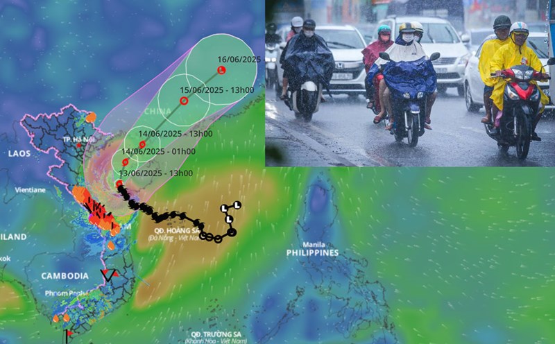
At 4:00 a.m. on June 14, the center of the storm was at about 19.8 degrees north latitude; 108.9 degrees east longitude, in the sea east of the Gulf of Tonkin, about 150km east of Bach Long Vi Island.
According to Mr. Mai Van Khiem - Director of the National Center for Hydro-Meteorological Forecasting, the strongest wind near the center of storm No. 1 has gradually decreased, strong at level 10 - 11, gusting to level 13. the storm moves slowly north at a speed of about 5km/h.
It is forecasted that in the next 12 hours, the storm will move north-northeast at a speed of about 15km/h and gradually weaken. At 4:00 p.m. on June 14, the center of the storm was at about 21 degrees north latitude; 109.9 degrees east longitude, in the coastal area west of Zhou Island (China). The strongest wind near the storm center is level 9 - 10, gusting to level 13.
The danger zone is north of latitude 17.5 degrees north; from longitude 106.5 to 111.5 degrees east. The natural disaster risk level is level 3, applied to the sea area of the Gulf of Tonkin and the northwest of the northern East Sea.
"It is forecasted that in the next 24 hours, the storm will move north-northeast at a speed of about 15km/h and continue to weaken" - Mr. Khiem commented.
At 4:00 a.m. on June 15, the center of the storm was at about 22.5 degrees north latitude; 110.9 degrees east longitude, in the area north of the Lusian Peninsula (China). The strongest wind near the storm center is level 8 - 9, gusting to level 12.
The danger zone is north of latitude 17.5 degrees north; from longitude 106.5 to 111.5 degrees east. The natural disaster risk level is level 3, applied to the sea area of the Gulf of Tonkin and the northwest of the northern East Sea.
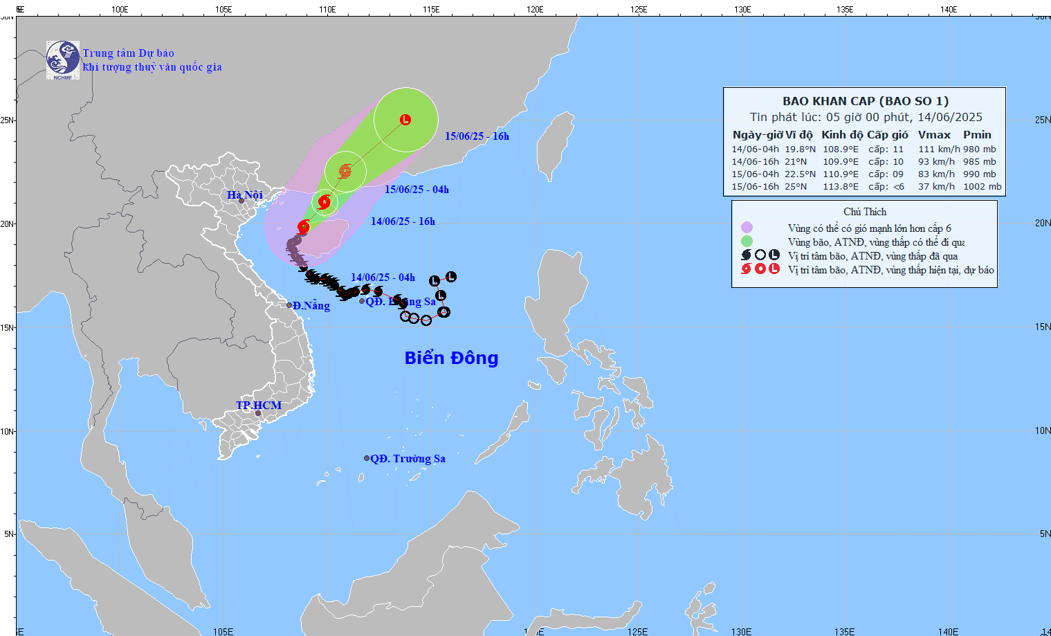
According to Mr. Mai Van Khiem, it is forecasted that in the next 36 hours, the storm will move northeast at a speed of about 20km/h, gradually weakening into a tropical depression and then continuing to weaken into a low pressure area.
At 4:00 p.m. on June 15, the center of the low pressure area was at about 25 degrees north latitude; 113.8 degrees east longitude, in the mainland area of Guangdong province (China). At this time, the low pressure area has winds below level 6.
The danger zone is north of the latitude of 20 degrees north; from the longitude of 106.5 to 113 degrees east. The natural disaster risk level is level 3, applied to the northern sea area of the Gulf of Tonkin and the northwest of the northern East Sea.
"Although storm No. 1 is gradually weakening, it continues to affect the Gulf of Tonkin sea area (including Co To and Bach Long Vi island districts) with strong winds of level 7, near the storm's eye level 8 - 9, gusts of level2; waves 2 - 4m high, especially in the east with waves 4 - 6m high; very rough seas" - representative of the meteorological agency updated the forecast of the storm's impact at sea.
In addition, the northwest of the East Sea will have strong winds of level 6, gusts of level 8; waves of 2 - 4m high; rough seas. Ship operating in the above-mentioned dangerous areas are likely to be affected by thunderstorms, whirlwinds, strong winds and large waves.
"On land, the rain due to storm No. 1 in the Central region has decreased significantly. The coastal areas of Quang Ninh - Hai Phong have strong winds of level 6, gusting to level 8; the coastal areas of Thai Binh - Nam Dinh have strong winds of level 4 - 5, gusting to level 6 - 7" - Mr. Mai Van Khiem said.