According to the meteorological agency, the weather forecast will fluctuate in the coming days. Mr. Nguyen Van Huong - Head of Weather Forecasting Department, National Center for Hydro-Meteorological Forecasting provided information on the natural disaster situation in the next 10 days (from August 14 to 24.

Sir, is there a risk of tropical cyclone formation in the East Sea in the next 10 days?
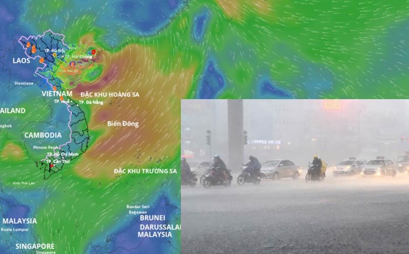
- We forecast that around August 14 - 15, a tropical convergence zone will form in the central East Sea, on this tropical convergence zone there is a possibility of forming a low pressure area, then it is likely to develop into a tropical depression with a probability of about 60 - 70%.
The sea area from Khanh Hoa to Ca Mau, the central and southern East Sea (including the western part of Truong Sa) will have strong southwest winds of level 6, gusting to level 7 - 8, waves from 2 - 3m high, rough seas. From August 16, thunderstorms and strong winds are likely to expand to the Gulf of Tonkin.
The sea area from Khanh Hoa to Ca Mau, Ca Mau to An Giang, the Gulf of Thailand, the southern sea area between the East Sea and the South East Sea (including the Truong Sa special area) will have showers and thunderstorms. During thunderstorms, beware of wave heights sometimes increasing to over 3m.
How is the impact of this low pressure area forecast to strengthen into a tropical depression, sir?
- Due to the influence of the tropical convergence zone, connecting with the low pressure area, it is forecasted to form in the East Sea area, from around August 15 to August 19, the North (mainly concentrated in the Northeast region) and provinces/cities from Thanh Hoa to Hue, the Central Highlands, the South are likely to experience a period of moderate rain, heavy rain over a wide area with a high risk of tornadoes, lightning, flash floods, landslides and localized flooding.
Is there anything noteworthy about the forecast of natural disasters from now until the end of August, sir?
- Through monitoring and analysis of the current status of the weather system and forecast products, it is shown that from now until the end of August 2025, there is a possibility of 1-2 storms/tropical depressions appearing in the East Sea.
On land in the Northern region, Central and Southern highlands, thunderstorms and localized heavy rain will still occur frequently in the late afternoon and evening.
Sincerely thank you!
Forecast of rainfall from now until September 10
The trend of rainfall nationwide is generally at the same level as the average of many years, especially in the area from Thanh Hoa to Hue and the South Central Coast, the total rainfall is forecast to be 10 - 30% higher than the average of many years in the same period.
The Northern region and the provinces from Thanh Hoa to Hue are likely to experience some widespread heavy rains. In the Central and Southern highlands, in the next month, there will be many days of showers and thunderstorms, mainly in the late afternoon; in which, some days may have moderate to heavy rain.
On a national scale, there is a continued possibility of dangerous weather phenomena such as thunderstorms, tornadoes, lightning, hail and strong gusts of wind.
The phenomenon of heavy rain and thunderstorms, whirlwinds, and lightning can negatively affect production activities and public health. In particular, beware of localized heavy rains that can cause floods, inundation in low-lying areas and landslides in mountainous areas.