According to the National Center for Hydro-Meteorological Forecasting, a tropical depression is currently active outside the sea east of the Philippines and is likely to strengthen into a storm in the next 24 hours.

Mr. Nguyen Van Huong - Head of Weather Forecast Department, National Center for Hydro-Meteorological Forecasting - said that the storm is then forecast to pass north of Luzon Island (Philippines) and enter the East Sea in the afternoon to evening of October 3.
"When entering the East Sea, the storm will move rapidly (at a speed of about 20 - 25 km/h) in a west-northwest direction towards Hainan Island (China). The intensity can gradually strengthen and reach a maximum of level 11 - 12. The storm is likely to enter the Gulf of Tonkin and affect our mainland" - Mr. Huong said.
However, according to the representative of the meteorological agency from October 4 onwards, forecasts on the direction and intensity are still dispersed between models, so it is necessary to continue monitoring and updating. At 11:00 on October 1, the National Center for Hydro-Meteorological Forecasting issued a bulletin on the tropical depression near the East Sea.
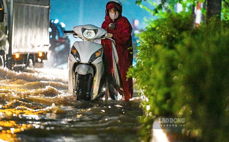
Regarding the impact of strong winds and big waves, from October 3, the sea area east of the northern East Sea will have winds gradually increasing to level 6 - 7, the area near the storm center will have strong winds of level 8, gusts of level 10, waves 2.5 - 4.5 m high, rough seas.
From October 4 to 6, the northern East Sea area (including Hoang Sa special zone) is likely to be affected by strong winds of level 10-11, gusting to level 14. Ship operating in the above-mentioned dangerous areas are likely to be affected by thunderstorms, whirlwinds, strong winds and large waves.
Previously, in September 2025, there were 4 storms in the East Sea, including storm No. 7 Tapah, storm No. 8 Mitag, storm No. 9 Ragasa and storm No. 10 Bualoi.
Storm No. 7: On September 5, a low pressure area in the northeastern part of the East Sea strengthened into a tropical depression, then continued to strengthen into a storm - storm No. 7 (international name Tapah) on the afternoon of September 6 with an intensity of level 8, gusting to level 10, the storm moved mainly northwest at a speed of 10 - 15 km/h.
By the morning of September 8, the storm moved in the mainland southwest of Guangdong province (China) with an intensity of level 10 - 11, gusting to level 13, after moving in, storm No. 7 gradually weakened into a tropical depression and then continued to become a low pressure area on the mainland of Guangxi province and gradually dissipated, not directly affecting the Vietnamese region.
Storm No. 8: On the night of September 17, the tropical depression in the northwest sea of Luzon Island (Philippines) entered the northeastern sea of the North East Sea; the strongest wind near the center of the tropical depression was level 7, gusting to level 9 and moving northwest at a speed of about 15 - 20 km/h.
At noon on September 18, the tropical depression strengthened into a storm, storm No. 8 with the international name Mitag with a strong intensity of level 8, gusts of level 10 and moving northwest at a speed of 15 - 20 km/h. On September 20, storm No. 8 weakened into a tropical depression in the southern area of Guangdong province (China), the strongest wind near the tropical depression was level 6, gusting to level 8, moving west-northwest, then becoming a low pressure area and gradually dissipating, not directly affecting Vietnam.
Storm No. 9: On the evening of September 22, super typhoon Ragasa entered the northeastern sea of the North East Sea, becoming the 9th storm in 2025; the strongest wind near the center of the super typhoon was level 17, gusting above level 17, moving west-northwest at a speed of 20 - 25 km/h. On the morning of September 24, after entering the southern sea area of Guangdong province (China), the super typhoon reduced its intensity to level 15.
On the morning of September 25, after entering the sea of Quang Ninh, storm No. 9 weakened into a tropical depression, with the strongest wind near the center of the tropical depression being level 7, gusting to level 9, moving westward at a speed of 15 - 20 km/h. Due to the influence of storm No. 9, in the Bach Long Vi special area (Hai Phong), there were strong winds of level 7, gusts of level 8, waves 2 m high. On the afternoon of September 25, the tropical depression weakened into a low pressure area in the Quang Ninh area.
Storm No. 10: On the evening of September 26, storm Bualoi entered the eastern sea of the central East Sea and became the 10th storm in 2025; the strongest wind near the storm center was level 12, gusting to level 15, moving west-northwest at a speed of 30 - 35 km/h. On the night of September 28, storm No. 10 made landfall in the Ha Tinh - North Quang Tri area, with the strongest wind near the storm center at level 11, gusting to level 14. At noon on September 29, storm No. 10 moved to the Upper Laos area, weakening into a tropical depression, then into a low pressure area.
Millions of arms turn to compatriots affected by storms and floods
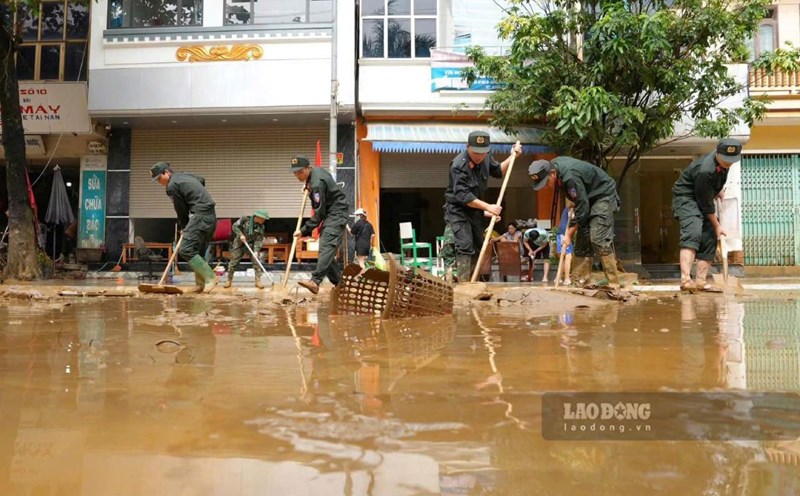
Consecutive storms 8, 9, 10 and floods caused by the storm have killed many people and left many people missing. Many houses and production and business establishments had their roofs blown off and suffered heavy damage. People across the northern and central mountainous provinces are struggling to cope with floods and heavy losses in human lives and property due to floods and thunderstorms.
"A piece of food when hungry is worth a package when full", with the spirit of mutual love that has always been a beautiful image of the Vietnamese people, the Golden Heart Social Charity Fund calls on domestic and foreign philanthropists to join hands to share with people affected by floods to have food, clothing, shelter, students have books to go to school...
The Golden Heart Social Charity Fund would like to sincerely thank the precious feelings of agencies, businesses, and domestic and foreign philanthropists.
All help please send to: The socialist fund of the golden heart, No. 51 Hang Bo, Hoan Kiem, Hanoi. Phone: 024.39232756. Account number (STK): 113000000758 at VietinBank Hoan Kiem Branch, Hanoi. STK: 0021000303088 - At Vietcombank - Hanoi Branch, STK: 12410001122556 - At BIDV - Hoan Kiem Branch. Or scan the following QR code: