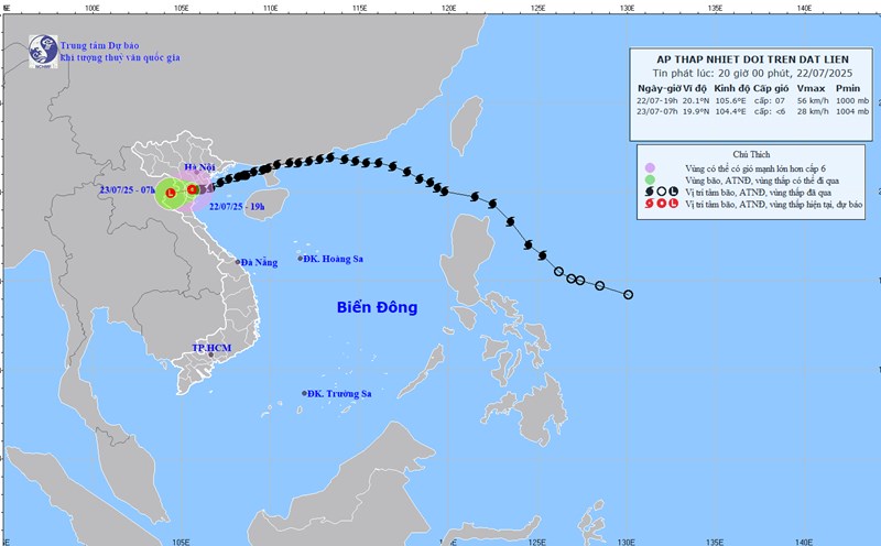
Previously, early in the morning of July 22, the National Center for Hydro-Meteorological Forecasting predicted that the intensity of storm No. 3 Wipha was about level 9, gusting to level 10-11 when it reached the mainland.
Some people believe that in some areas, the impact of storms on heavy rain and strong winds when making landfall is not as large as previously forecast.
Storm No. 3 Wipha departs north, causing winds to decrease before making landfall

However, according to actual measurement data from the meteorological agency, due to the impact of storm No. 3, from the afternoon of July 21 to noon of July 22, strong winds occurred widely in the coastal areas of the North and North Central regions.
At Bach Long Vi Special Zone (Hai Phong), strong winds of level 10 were recorded, gusting to level 12; Co To Special Zone (Quang Ninh) level 9, gusting to level 11; Cat Ba - Cat Hai Special Zone (Hai Phong) level 6, gusting to level 8.
Some coastal stations have very strong winds such as Cua Ong (Quang Ninh) level 10, gust level 12; Quang Ha (Quang Ninh) level 9, gust level 11; Bai Chay (Quang Ninh) level 8, gust level 10; Tien Yen (Quang Ninh) level 10, gust level 14 - this is the point where the strongest gusts of wind were recorded during this storm.
In addition, stations such as Mong Cai (Quang Ninh) level 7, gust level 9; Thai Binh level 7, gust level 8; Ba Lat (Hung Yen) level 8, gust level 9; Hon Dau (Hai Phong) level 8, gust level 9; Phu Lien (Hai Phong) level 6, gust level 8.
Regarding the storm's decline, according to Mr. Mai Van Khiem - Director of the National Center for Hydro-Meteorological Forecasting, on the morning of July 21, the storm passed through the northern area of the Lusian Peninsula (China), entering the Gulf of Tonkin; level 9 intensity.
"When moving into the Gulf of Tonkin, it has decreased by 3 levels, from level 12 to level 9. This change is due to the fact that last night when it reached the coast of Guangdong, China, the storm shifted north along the mainland, creating friction that reduced the energy source, causing the storm intensity to decrease" - Mr. Khiem analyzed.
When entering the coastal waters of Hai Phong - Ninh Binh, the strongest wind near the storm center is level 9, gusting to level 12 - also decreasing by 1 level compared to the previous forecast. According to Mr. Khiem, the Gulf of Tonkin is not deep and wide enough to add much energy to the storm.
"When entering the northern Gulf of Tonkin, the storm tends to approach the coastal waters of Quang Ninh - Hai Phong province, so the storm does not store more energy combined with friction, so the storm intensity weakens to level 9 right before the storm makes landfall, when entering Hung Yen - Ninh Binh, the storm intensity decreases to level 8, gusting to level 10" - Mr. Khiem added.
Rain circulation is located south of the storm's eye
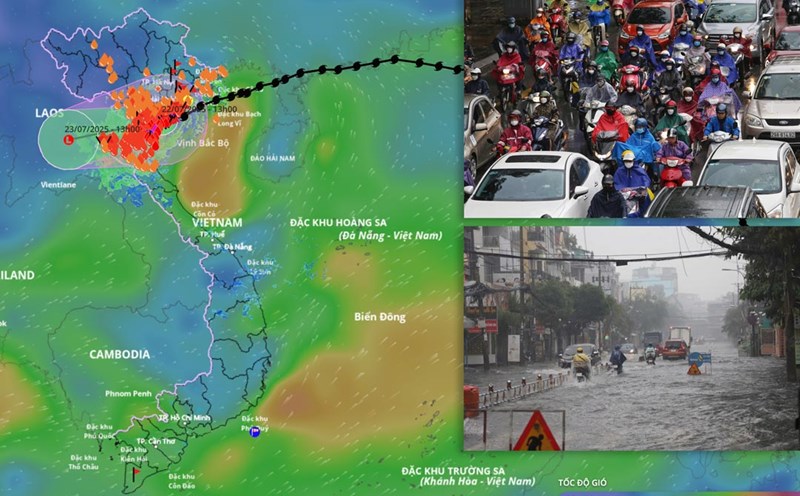
Regarding heavy rain, in fact, the circulation of storm No. 3 caused widespread heavy rain in the North and North Central regions. From the morning of July 21 to the afternoon of July 22, the Northern Delta, Thanh Hoa, Nghe An will have common rain of 100 - 200mm, many places exceeding 300mm.
In particular, in Nga Son (Thanh Hoa), the rain reached 412.6mm, Sam Son 379.5mm, Trieu Son 336.2mm, Nhu Thanh 327.4mm, Ba Dinh 326.8mm, Hac Thanh 315.8mm.
The monitoring stations of Hai Anh, Giao Linh, Tam Diep (Ninh Binh) also recorded over 260mm. Some coastal places such as Van Don (Quang Ninh) and Cat Hai (Hai Phong) exceeded 180mm.
Previously, the Northeast and Hanoi regions were forecast to be in the focus of rain. However, in reality, when the storm made landfall on July 22, the above provinces and cities had less rain, some places had light sunshine.
According to the meteorological agency, on July 21, when the storm entered the northern part of the Gulf of Tonkin, the entire Northeast region, the Northern Delta provinces, including Hanoi, had rain from the afternoon to the early morning of July 22.
"From the night of July 21 to the morning of July 22, the storm will move west-southwest (ie from the sea areas of Quang Ninh provinces to Hai Phong, Hung Yen) and then on the coast of Hung Yen - Ninh Binh. Therefore, along with the movement of the storm, the storm's circulating cloud area also moves south" - Mr. Khiem said.
Therefore, the storm cloud circulation on July 22 caused a lot of rain in Ninh Binh, Thanh Hoa, Nghe An provinces. Meanwhile, localities located in the northern part of the storm's circulation such as Hanoi and the Northeast region have gradually decreased in rain compared to the day and night of July 21.

Mr. Hoang Phuc Lam - Deputy Director of the National Center for Hydro-Meteorological Forecasting also explained the uneven rain distribution, heavy rain in places and sunlight in places, even though they are affected by the storm's circulation.
According to Mr. Lam, in a storm or weather cloud system, not all cloud areas are likely to cause rain, because there may be many different types of clouds. For example, high-level clouds often only cover the sun. Therefore, there are areas where even though they are covered with clouds, there is still no rain, or sometimes the rain is interrupted and then stops.
"Even in a hurricane circulation system, differences in rainfall, strong winds and danger levels are common. Some places have gusts of level 89, causing roofs to blown off and trees to fall; some places are just cloudy, no rain and even light sunshine" - Mr. Lam analyzed.
A representative of the meteorological agency warned that the rain will continue but there may be interruptions on July 23.