After 7:00 p.m. tonight, storm No. 10 Bualoi made landfall, forecasting the area with the strongest winds

AN AN |

After 7:00 p.m. tonight, September 28, the center of storm No. 10 Bualoi is likely to make landfall in the provinces from northern Quang Tri to Nghe An, the area of wide impact.

Storm No. 10 Bualoi is considered a dangerous storm, affecting the mainland more strongly than the recent super typhoon No. 9 Ragasa due to no signs of weakening as it approaches the shore

This morning, September 28, Mr. Mai Van Khiem - Director of the National Center for Hydro-Meteorological Forecasting, Department of Hydro-Meteorology, gave the latest comments related to the developments and impacts of this storm.

Ong
Mr. Mai Van Khiem - Director of the National Center for Hydro-Meteorological Forecasting warned that storm No. 10 Bualoi could bring many dangerous natural disasters. Photo: An An

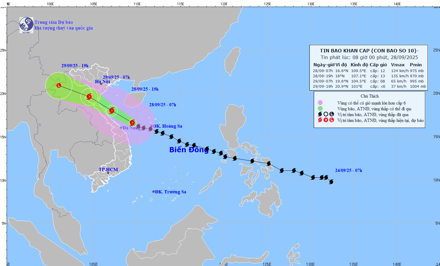
Sir, how is the updated forecast on the time and area of storm No. 10 Bualoi making landfall and when will the mainland begin to be directly affected?

- Storm No. 10 Bualoi in the past 24 hours has maintained a very strong intensity - at level 12, and is forecast to continue to maintain this intensity before approaching the mainland.

Although the speed has decreased slightly to about 25km/h, it is still very fast. With such a rapid movement, this evening (September 28), the storm will directly affect the mainland from Quang Tri to Nghe An.

After 7:00 p.m. tonight, September 28, the center of the storm will make landfall. is likely to make landfall from northern Quang Tri to Nghe An.

How do you assess the impact of this storm and which areas will be the focus of impact, sir?

- This is a very fast moving storm, very strong storm intensity, wide range of impact, which can cause the combined impact of many types of natural disasters such as strong winds, heavy rain, floods, flash floods, landslides and coastal flooding.

First of all, the impact of strong winds and large waves at sea, we are predicting a very wide impact from the North Central Coast to the Northern Coast. The strong wind area around the center of the storm may reach level 10 - 13, gusting to level 16. Specifically, the sea area from Thanh Hoa to Quang Ngai (including Hon Ngu island, Con Co and Ly Son specialties) may have winds of level 10 - 13, gusts of level 16, waves 5-7m high, and rough seas. With such strong winds and waves 5-7m high, it is extremely dangerous for ships.

Cap nhat vi tri va duong di cua bao so 10 Bualoi vao 8 gio ngay 28.9. Nguon: Trung tam Du bao Khi tuong Thuy van Quoc gia
Updated location and path of storm No. 10 Bualoi at 8:00 a.m. on September 28. Source: National Center for Hydro-Meteorological Forecasting

On land, the wind is also very strong, it is forecasted that the focus area of the storm passing through such as the area from Thanh Hoa to North Quang Tri may have strong winds of level 10 - 12, gusting to level 15 - extremely dangerous for the infrastructure system. The wind can knock down trees, houses, and electric poles, causing serious damage.

This storm No. 10 is also at risk of causing a widespread heavy rain in the North Central and Northern regions. The Northern Delta, South Phu Tho and from Thanh Hoa to the north of Quang Tri have common rainfall from 200-400mm, locally over 600mm.

With such heavy rain, the risk of flooding on some rivers in the North and North Central regions with the flood peak reaching alert level 2 - alert level 3, some rivers may be above alert level 3. With such a flood, the risk of flooding along rivers and downstream rivers is very high.

The risk of flash floods and landslides in mountainous areas is very high not only today but in the next 2-3 days.

With such a strong storm impact forecast, what recommendations do you have for people to minimize damage?

- Up to this point, it can be confirmed that storm No. 10 has a very dangerous impact on the sea and inland areas. We hope that people must absolutely follow the instructions of local authorities in responding to storm No. 10.

All solutions have been guided by telegrams. We pay special attention to strong winds and big waves as forecast, absolutely do not stay on coastal boats and cages.

During the forecast period, from around late afternoon to tonight (September 28), the wind is very strong on land, people absolutely do not try to go outside. In addition, major floods may occur on rivers, people should not go through spillways or fish in rivers and streams.

People in rivers, streams, mountainous areas, and hillsides need to especially prevent flash floods and landslides from now until the next 2-3 days.

Sincerely thank you!

AN AN
RELATED NEWS

Storm No. 10 Bualoi is very strong, causing heavy rain and strong winds from today before making landfall

|

According to the meteorological agency, storm No. 10 Bualoi is maintaining a very strong intensity - level 12, gusting to level 1; will cause heavy rain and strong winds in the North and North Central regions from today, September 28.

Weather today, September 28: Storm No. 10 Bualoi causes heavy to very heavy rain

|

Weather today, September 28, the area from Thanh Hoa to Quang Ngai will have heavy to very heavy rain. The North will have scattered showers and thunderstorms, with some places having heavy to very heavy rain from this afternoon.

Storm No. 10 Bualoi strengthens and goes twice as fast as other storms, forecast time of landfall

|

It is forecasted that by tomorrow night, September 28, storm No. 10 Bualoi will make landfall in Nghe An - Quang Tri. This is a strong storm, traveling nearly double the speed of the average storm.

Strong cold air is about to impact, lowest temperature forecast for cold in the coming days

|

Around the afternoon and night of November 17, strong cold air will affect the Northeast region.

Close-up of the hundred-year-old bridge across the Huong River, 3 times dispatched ships to guard it in the midst of floods

|

HUE - More than 117 years old, the Bach Ho - Da Vien railway bridge has been sent to the harbor by ship carrying rocks 3 times in just one week of floods.

Violations in public land management in Gia Lai revealed, inspectors propose to prosecute a series of officials

|

Gia Lai - The Inspectorate transferred the entire dossier to the Provincial Police Department, recommending prosecuting a series of officials related to land violations in Quy Nhon Tay Ward.

Scenes of the landslide in Da Nang, supporting the search for missing victims

|

Da Nang - Three convection points were brought to the pat village landslide site to support the search for missing victims.

Mr. Nguyen Khac Toan was introduced to be elected Chairman of the Hue City People's Committee

|

HUE - The Secretariat decided to transfer Mr. Nguyen Khac Toan to hold the position of Deputy Secretary of the Hue City Party Committee and introduced him to be elected Chairman of the Hue City People's Committee.

Storm No. 10 Bualoi is very strong, causing heavy rain and strong winds from today before making landfall

AN AN |

According to the meteorological agency, storm No. 10 Bualoi is maintaining a very strong intensity - level 12, gusting to level 1; will cause heavy rain and strong winds in the North and North Central regions from today, September 28.

Weather today, September 28: Storm No. 10 Bualoi causes heavy to very heavy rain

LINH ANH |

Weather today, September 28, the area from Thanh Hoa to Quang Ngai will have heavy to very heavy rain. The North will have scattered showers and thunderstorms, with some places having heavy to very heavy rain from this afternoon.

Storm No. 10 Bualoi strengthens and goes twice as fast as other storms, forecast time of landfall

AN AN |

It is forecasted that by tomorrow night, September 28, storm No. 10 Bualoi will make landfall in Nghe An - Quang Tri. This is a strong storm, traveling nearly double the speed of the average storm.