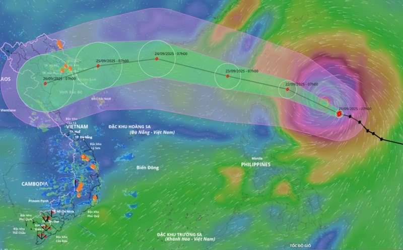
According to the National Center for Hydro-Meteorological Forecasting, at 7:00 a.m. on September 22, the center of super typhoon Ragasa was at about 19.3 degrees north latitude; 123.1 degrees east longitude, about 160km northeast of Luzon Island (Philippines). The strongest wind near the storm center is level 17 (202 - 221km/h), gusting over level 17. The super typhoon is moving west-northwest at a speed of about 20km/h.
It is forecasted that in the next 24 hours, the super typhoon will move west-northwest at a speed of about 20km/h and enter the East Sea.

According to Mr. Mai Van Khiem - Director of the National Center for Hydro-Meteorological Forecasting, it is forecasted that tonight (September 22), the storm will enter the East Sea, becoming the 9th storm of the year, moving quickly at about 20 km/h and maintaining the maximum intensity of level 16 - 17, gusting above level 17 on September 22 - 23.
"With such an intensity, super typhoon Ragasa is equivalent to or exceeds the intensity of typhoon No. 3 Yagi in 2024 and is in the group of strongest super typhoons ever to appear in the East Sea" - Mr. Khiem emphasized.
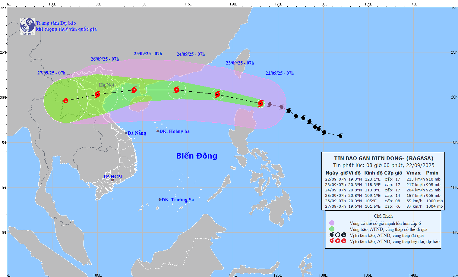
At 7:00 a.m. on September 23, the center of the storm was at about 20.3 degrees north latitude; 118.3 degrees east longitude, in the northeastern sea area of the northern East Sea. Strong intensity level 17, gust above level 17.
The danger zone is the area north of the 18-degree north latitude, east of the 115.5 degree east longitude. Level 4 natural disaster risk for the eastern sea area of the northern East Sea.
It is forecasted that in the next 48 hours, the super typhoon will move west-northwest at a speed of about 20km/h.
At 7:00 a.m. on September 24, the center of the storm was at about 20.8 degrees north latitude; 113.8 degrees east longitude, in the northern sea area of the northern East Sea, about 370km east of the Lusian Peninsula (China). Strong intensity level 16-17, gust above level 17.
The danger zone is the area north of the latitude of 18.5 degrees north latitude, east of the longitude of 111 degrees east longitude. Level 4 natural disaster risk for the northern sea area of the northern East Sea.
It is forecasted that in the next 72 hours, the super typhoon will mainly move west at a speed of 15-20km/h and gradually weaken.
"By the morning of September 25, the storm is likely to enter the Gulf of Tonkin with an intensity of level 12 - 14, gusting to level 15 - 16 and is forecast to directly affect the mainland of our country from Quang Ninh to Ha Tinh" - Mr. Khiem said.
According to the Director of the Meteorological Agency, international and Vietnamese forecasting centers all assessed that Ragasa has a very wide circulation, complex trajectory and intensity due to interaction with the first cold air mass of the season, just a 50 - 100 km deviation of the storm will cause a big difference in the scope and intensity of impact.
It is forecasted that in the next 72 to 120 hours, the storm will move west-southwest, traveling about 20km per hour, and continue to weaken.
Mr. Khiem said that from September 23, the North East Sea area is forecast to have strong winds of level 10-14, near the center of the storm level 15-17, gusts above level 17, waves above 10 m high, and rough seas.
"From September 24-26, the Gulf of Tonkin and the coastal areas of the North - North Central regions are likely to have strong winds of level 9-12, near the storm center level 12-14, gusting to level 15-16, with widespread heavy rain" - Mr. Khiem added.
Ship operating in the above-mentioned dangerous areas are likely to be affected by thunderstorms, whirlwinds, strong winds and large waves.