
The latest storm and low pressure bulletin from the Philippine Atmospheric, Geophysical and Astronomical Services Administration (PAGASA) on the morning of July 31st said that 2 low pressure areas are expected to form between now and August 12th.
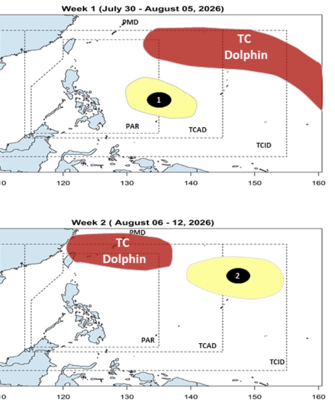
The bulletin said that in the process of continuously moving westward, towards northern Taiwan (China) and eastern China, Super Typhoon Dolphin will continuously move northwest in the northeast area of PAGASA's PMD forecasting area. Next week from August 6-12, Super Typhoon Dolphin will go deeper into the northern boundary of PMD.
During this time, 2 low pressure areas will form in succession near the Philippines. The first low pressure area will form in the week from July 30 to August 5 on the eastern boundary of PAGASA's PAR and TCAD forecast areas. This low pressure area is unlikely to strengthen into a storm or tropical depression.
The 2nd low pressure area is forecast to form in the week from August 6-12 in the northeast of PMD and is also unlikely to strengthen.
In fact, PAGASA is monitoring low pressure 07f outside the forecast area of the Philippines. The latest data shows that this low pressure is 1.455km east of Eastern Visayas, Philippines and is unlikely to strengthen into a storm or tropical depression.
Meanwhile, the latest storm news from the Japan Meteorological Agency (JMA), super typhoon Dolphin is expected to move northwest until August 2. After that, the super typhoon will move west towards the Volcano Islands from August 3.
Current forecast models predict that the eye of Typhoon Dolphin is likely to enter the northeastern boundary of PAR in the middle of next week at strong typhoon intensity. If it enters PAR, Dolphin will have the Philippine name Luis.
To date, the scenario of a storm making landfall in the Philippines is unlikely to happen. Based on forecast models, the latest storm of the 2026 storm season may increase the intensity of the southwest monsoon across the Philippines from August 4. Rainfall forecasts of more than 100 mm will be recorded in the western Luzon and Visayas areas in the week from August 6 to 12. 8.
According to the Hong Kong Meteorological Bureau (China), HKO super typhoon Dolphin has reached super typhoon level in the Pacific Ocean in just 3 days, with maximum winds reaching 270 km/h, equivalent to super typhoon level 5, the highest level on the Saffir-Simpson scale.
HKO's weather blog noted that both computer forecasting and artificial intelligence models show that the storm may strengthen further, possibly close to or exceeding historical records.
Most forecast models predict that super typhoon Dolphin will maintain and strengthen in favorable conditions: extremely high seawater temperatures and weak gusts.
The final intensity of super typhoon Dolphin depends on whether the storm's structure is preserved and whether the super typhoon encounters obstacles such as the intrusion of dry air or the cycle of replacing it as a storm eye.
HKO pointed out that the strongest tropical storm recorded in the northwest Pacific was Typhoon Tip in 1979 and Typhoon Nancy in 1961. Both storms had maximum sustained winds estimated at 305 km/h.


