Low pressure near the East Sea may form from this week, this year's storm is likely to make landfall

Thanh Hà |

The low pressure may form near the East Sea from this week with a very wide area of influence. Forecasters also said that this year's storm will easily make landfall.

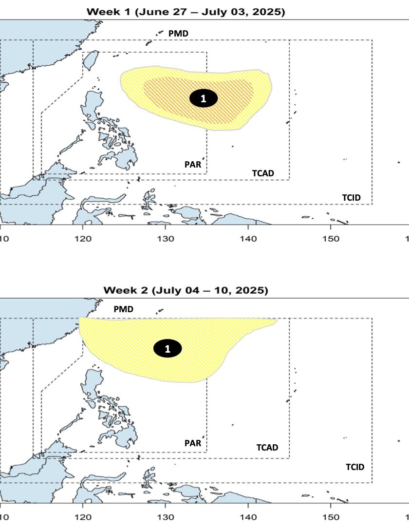
The latest storm and low pressure information on June 27 from the Philippine Atmospheric, Geophysical and Astronomical Services Administration (PAGASA) said that it is expected that from June 27 to July 10, a low pressure near the East Sea with a wide area of influence will form.

The new low pressure is expected to form in the eastern boundary of the Philippine Forecast Area (PAR) and PAGASA's TCAD forecast area during the week of June 27 to July 3, with the possibility of strengthening into a low to moderate storm.

In the week from July 4 to July 10, the low pressure near the East Sea will expand its influence, move north of PAGASA's PMD forecast area and is unlikely to strengthen into a storm.

Ap thap gan Bien Dong du bao hinh thanh trong nhung ngay toi. Anh: PAGASA
The low pressure area near the East Sea is forecast to form in the coming days. Photo: PAGASA

Previously, in the monthly climate forum on June 25, PAGASA forecasters said that the Philippines could see 11 to 19 typhoons from July to December 2025.

PAGASA's monthly forecast details are as follows: 2-3 storms are expected to form in July, 2-3 storms in August, 2-4 storms in September, 2-4 storms in October, 2-3 storms in November and 1-2 storms in December.

"Storms in the coming months are more likely to make landfall. The storms during this period could also intensify the southwest monsoon," explained PAGASA expert Joe Figuracion.

So far, only the tropical depression named Auring has entered the PAR in June and lasted for 6 hours (from 8:00 p.m. on June 12 to 2:00 a.m. on June 13.6).

July storms near the East Sea typically follow in three directions: Riding towards the northern boundary of the PAR and moving towards Taiwan (China) or Japan without making landfall; crossing northern Philippines, such as the Batanes or Babuyan Islands, before heading towards China or Hong Kong (China; or the storm passing through the northern center of Luzon, entering the East Sea and heading towards Vietnam.

From July to September, rainfall in the Philippines may be near average, except in northwestern Luzon, where there may be below-normal rainfall in July. From August to September, rainfall is expected to remain near normal nationwide.

From October to December, most areas could see rainfall close to or above normal, with the above conditions likely to increase from August to the end of the year.

Increased rainfall is often associated with the occurrence of storms during this period, as storms entering or forming within the PAR often lead to widespread rain, direct rain inland or indirectly by enhancing habagat.

Previously, PAGASA weather forecasters said that this year's rainy season will be at a normal level, but note that there is still a risk of heavy rain, flooding and landslides along with other devastating impacts.

Thanh Hà
TIN LIÊN QUAN

4 low pressure areas appear simultaneously, threatening to cause widespread heavy rain

|

The US National Hurricane Center is monitoring four depressions, including two in the Caribbean.

World 24h: Forecast of the impact of low pressure near the East Sea

|

Latest world news 26.6: World gold prices increase; Warning of a new low pressure area near the East Sea causing heavy rain this weekend...

Right after storm No. 2 Sepat, a new low pressure will appear near the East Sea

|

Typhoon Sepat, the second storm in the northwest Pacific, is forecast to weaken on June 25. Immediately after that, a new low pressure area will form near the East Sea.

Forecast of very heavy rain in the North, warning of dangerous weather

|

According to the representative of the meteorological agency, the widespread heavy rain in the North is forecast to last from the night of June 28 to July 2.

Ha Truc Linh - the journey from Miss Finance Marketing to Miss Vietnam 2024

|

The new Miss Vietnam 2024 Ha Truc Linh stands out with her beautiful face, impressive performance skills and good education.

Germany prevents Nord Stream 2 from changing owners, prevents Russian gas from returning to Europe

|

Germany is promoting a law amendment to prevent non-EU investors, especially from Russia and the US, from acquiring companies that own the Nord Stream 2 pipeline.

Russia and Ukraine regularly exchange after negotiations

|

The Russian president said the two sides will remain in regular contact and are ready for a third round of talks.

US optimistic about rare earths and agreements with China

|

The US believes that rare earth supply will be resumed after making progress in negotiations with China.

4 low pressure areas appear simultaneously, threatening to cause widespread heavy rain

Thanh Hà |

The US National Hurricane Center is monitoring four depressions, including two in the Caribbean.

World 24h: Forecast of the impact of low pressure near the East Sea

nhóm pv |

Latest world news 26.6: World gold prices increase; Warning of a new low pressure area near the East Sea causing heavy rain this weekend...

Right after storm No. 2 Sepat, a new low pressure will appear near the East Sea

Thanh Hà |

Typhoon Sepat, the second storm in the northwest Pacific, is forecast to weaken on June 25. Immediately after that, a new low pressure area will form near the East Sea.