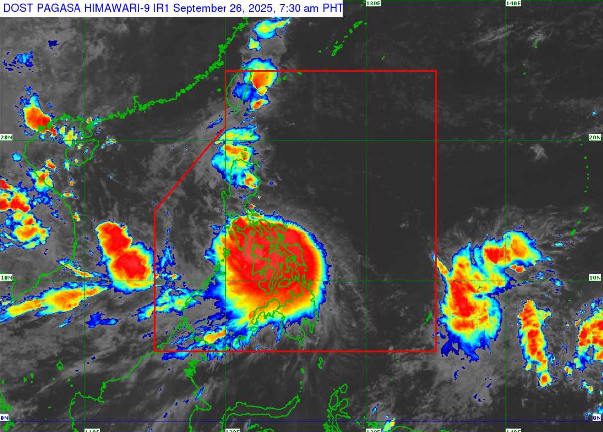
The Philippine Atmospheric, Geophysical and Astronomical Services Administration (PAGASA) said that Typhoon Bualoi (local name Opong) made its second landfall in Palanas at 4:00 a.m. on September 26, while the first landfall was in San Policarpo, Eastern Samar at 11:30 p.m. on September 25.
The storm is accelerating as it moves west-northwest. At 7:00 a.m. on September 26, the center of the storm was at 12.3 degrees North latitude, 123.1 degrees East longitude, in the coastal waters of Mandaon, Masbate.
Maximum winds near the center of the storm are 110 km/h (level 11), gusting to 150 km/h (level 14), central pressure 985 hPa.
The storm is moving west-northwest at a speed of 30 km/h. The tropical cyclone wind radius is 460km from the center of the storm.
Due to the impact of the storm, waves up to 11m high in the coastal areas of Eastern Samar, Northern Samar, Samar, Biliran, Masbate include the islands of Ticao and burias; the southern and eastern coasts of Albay and Sorsogon.
There is a moderate to high risk of storm surge, endangering life, with peak elevation reaching 1-3m within 24 hours in low coastal areas.
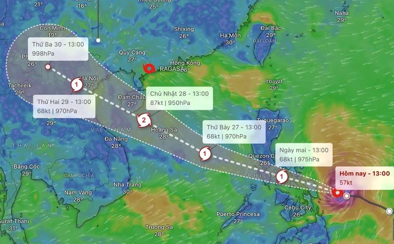
The storm is forecast to continue moving west-northwest and may make landfall or pass near the provinces of Romblon and Mindoro within the next 12 hours, before entering the East Sea this afternoon or evening. The possibility of Typhoon Bualoi strengthening is very high when it enters the East Sea, becoming Typhoon No. 10.
According to the storm forecast of the Vietnam National Center for Hydro-Meteorological Forecasting:
At 7:00 a.m. on September 27, storm No. 10 in the East Sea tends to strengthen. Moving in the West Northwest direction, 30-35 km/h.
Location: 14.5 degrees North latitude - 116.6 degrees East longitude, wind speed level 11-12, gusts level 15.
Dangerous area: 11.5-17.0 degrees North latitude; East longitude 114.0 degrees East longitude.
Natural disaster risk: Level 3 (Northern and Central East Sea).
7:00 a.m. on September 28: The storm is moving in a West-Northwest direction, 30 km/h, continuing to strengthen.
Location: 16.7 degrees North latitude - 110.5 degrees East longitude, wind speed level 13, gust level 16.
Dangerous area: 12.0-20,0 degrees North latitude; East longitude 108.0 degrees East longitude.
Natural disaster risk: Level 3 (North and Central East Sea, Hoang Sa, South Quang Tri - Quang Ngai sea area).
7:00 a.m. on September 29: The storm is moving in a West-Northwest direction, 25 km/h.
Location: 19.0 degrees North latitude - 105.5 degrees East longitude, wind speed level 12, gust level 15.
Dangerous area: 13.5-21.0 degrees North latitude; Western longitude 113.5 degrees East longitude.
Natural disaster risk: Level 3 (Northwest and Central East Sea, Hoang Sa, South Quang Tri - Quang Ngai, South Gulf of Tonkin).
From the afternoon of September 26: The northeastern and central East Sea will have winds of level 6-7, then increase to level 8-9.
Area near the storm center: Wind level 10-12, gusts of level 15, waves 5.0-7.0m high, rough seas.
Ship in the danger zone are likely to be affected by thunderstorms, whirlwinds, strong winds, and large waves.