Typhoon Dolphin continues to strengthen, forecast direction for the next 72 hours

Châu Anh |

Typhoon Dolphin continues to strengthen in favorable conditions and is forecast to sweep through the Okinawa Islands (Japan) at the end of this week on a very large scale.

According to the latest weather news updated at 5 am on August 4 (Manila time, Philippines), Typhoon Dolphin continues to strengthen as it moves over the Western Pacific Ocean and is forecast to go straight through the Okinawa archipelago (Japan).

The Japan Meteorological Agency (JMA) said that Hurricane Dolphin is currently a very strong storm, with sustained winds of 155 km/h, central pressure of 945 hPa. Meanwhile, the Philippine Atmospheric, Geophysical and Astronomical Services Administration (PAGASA) recorded winds of about 150 km/h, and the US Joint Typhoon Warning Center (JTWC) assessed Dolphin as equivalent to a Category 2 storm on the Saffir-Simpson scale, with winds of about 175 km/h.
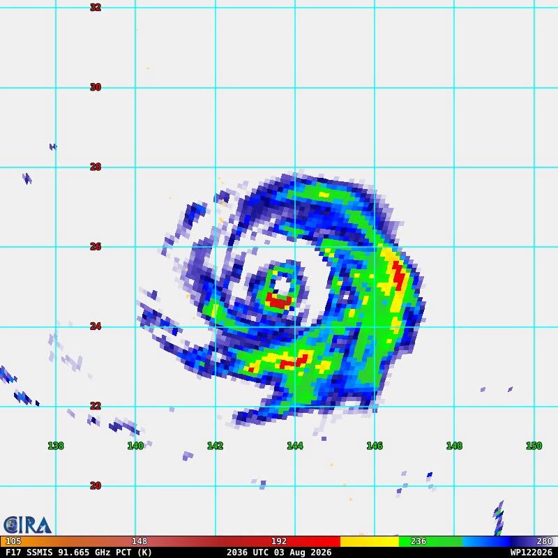
Ảnh vệ tinh hồng ngoại ghi nhận bão Dolphin duy trì cấu trúc mắt bão rõ nét và hoàn lưu rộng, cho thấy cơn bão vẫn ở trạng thái mạnh khi tiến về khu vực Okinawa. Ảnh: CIRA
Infrared satellite images recorded Hurricane Dolphin maintaining a clear eye structure and wide circulation, showing that the storm is still in a strong state as it moves towards the Okinawa area. Photo: CIRA

According to meteorologists, in the past few hours, a more favorable atmospheric environment has helped the storm's core structure continue to be strengthened. Convective cloud bands are growing strongly around the eye of the storm, causing Dolphin to increase in intensity after failing to complete the cycle of replacing it as a fourth eye of the storm.

Forecasts show Dolphin will continue to move westward in the next 4 days. After that, the storm's speed will slow as the subtropical high pressure weakens under the impact of a low trough passing through Siberia. As the high pressure in the northwest gradually recedes eastward, the storm will shift to the northwest.
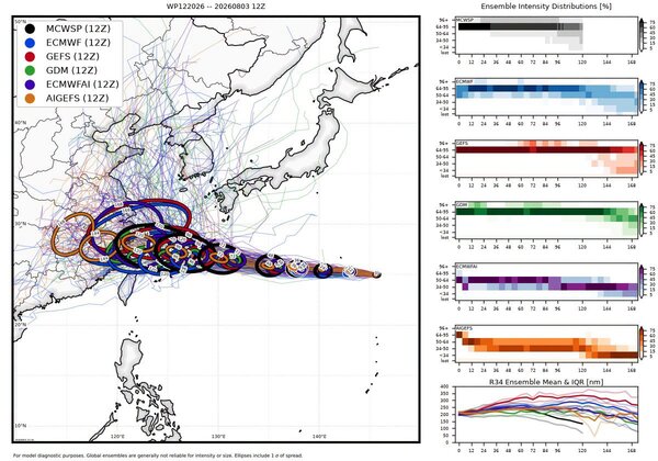
Các mô hình dự báo quốc tế đều cho thấy bão Dolphin có xu hướng di chuyển về phía tây rồi bẻ hướng tây bắc, tiến gần quần đảo Ryukyu và Okinawa trong những ngày tới. Ảnh: Weather Models.
International forecast models all show that Typhoon Dolphin tends to move westward and then bend northwest, approaching the Ryukyu and Okinawa archipelagoes in the coming days. Photo: Weather Models

According to JMA's latest trajectory, the eye of the storm is likely to pass directly through the Okinawa archipelago in the period from the evening of August 6 to the morning of August 7, increasing the risk of heavy rain, strong winds and dangerous rough seas in this area.

PAGASA believes Dolphin is unlikely to enter the Philippine Area of Responsibility (PAR). However, the wide circulation of the storm will continue to strengthen the southwest monsoon (Habagat), increasing rainfall in many areas of the Philippines until early next week.

At the same time, PAGASA is still monitoring the Luis tropical depression inside PAR. The combination of Luis's circulation and the southwest monsoon is forecast to continue to cause rain in many places in the northern Philippines in the coming days.

Châu Anh
RELATED NEWS

Dolphin storm changes direction, warning of heavy rain in many areas

|

Philippine meteorologists believe that Typhoon Dolphin is unlikely to make landfall but could still strengthen the southwest monsoon, causing heavy rain at the weekend.

Hurricane Dolphin approaches Luis low pressure, a rare meteorological phenomenon is about to occur

|

Tropical depression Luis is forecast to interact with Hurricane Dolphin, causing complicated developments for the region's weather.

Tropical depression Luis forms near the East Sea, may soon strengthen into a storm

|

Tropical depression Luis forms near the Philippines while super typhoon Dolphin has weakened, but the expanded wind area strengthens the southwest monsoon in Southeast Asia.

Ho Chi Minh City requests termination of sub-licenses before August 10

|

Ho Chi Minh City requests to stop the situation of arising "sub-licenses", processes or documents outside regulations before August 10, 2026.

109 contestants compete at the 6th All-Army Mechanical Skills Contest, 2026

|

Tuyen Quang - On August 4, the National Defense Trade Union opened the 6th All-Army Mechanical Skills Competition, 2026.

Typhoon Dolphin continues to strengthen, forecast direction for the next 72 hours

|

Typhoon Dolphin continues to strengthen in favorable conditions and is forecast to sweep through the Okinawa Islands (Japan) at the end of this week on a very large scale.

Dolphin storm changes direction, warning of heavy rain in many areas

Châu Anh |

Philippine meteorologists believe that Typhoon Dolphin is unlikely to make landfall but could still strengthen the southwest monsoon, causing heavy rain at the weekend.

Hurricane Dolphin approaches Luis low pressure, a rare meteorological phenomenon is about to occur

Châu Anh |

Tropical depression Luis is forecast to interact with Hurricane Dolphin, causing complicated developments for the region's weather.

Tropical depression Luis forms near the East Sea, may soon strengthen into a storm

Thanh Hà |

Tropical depression Luis forms near the Philippines while super typhoon Dolphin has weakened, but the expanded wind area strengthens the southwest monsoon in Southeast Asia.
