
The latest storm and low pressure news on the morning of August 2nd from the Philippine Atmospheric, Geophysical and Astronomical Services Administration (PAGASA) said that tropical depression Luis (formerly low pressure area 07f) is within the Philippine Area of Responsibility (PAR).
The center of the Luis tropical depression is about 340km east of Daet, Camarines Norte province, with sustained winds of 55 km/h, gusts of 70 km/h. This tropical depression near the East Sea is moving slowly in a west-southwest direction.
Tropical depression Luis formed from the evening of August 1. At that time, the center of the tropical depression was about 360km east of Daet, Camarines Norte. Luis has maximum sustained winds of 45 km/h, gusts of up to 55 km/h and is moving west at a speed of about 15 km/h. The strong wind area of the system expands within a radius of about 50 km from the center.
Meanwhile, PAGASA's storm news on the morning of August 2 said that Typhoon Dolphin has entered PAGASA's TCID monitoring area. The storm's eye is about 3,430km east of the northernmost point of Luzon Island. This once fierce super typhoon currently has sustained winds of 185 km/h, gusts of 230 km/h, moving west-northwest at a speed of 25 km/h.
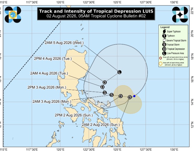
According to PAGASA storm forecasters, Luis will slow down as it moves west-northwest until the end of August 2, then turn east-northeast in the following days.
With the current forecast trajectory, the latest tropical depression of the 2026 storm season is still mainly operating in the sea area east of the Philippines. However, the Philippine weather forecast agency noted that it does not rule out the possibility that Luis's trajectory shifts westward, causing the system to land or approach the north of Luzon Island.
It is forecast that Luis will strengthen into a tropical storm on August 3 when it is still in the sea east of central Luzon.
Tropical depression Luis is the 12th system to appear in PAR since the beginning of the year and the first system to form in August.
Current forecast models warn that Luis may have a binary interaction (Fujiwhara effect) with Hurricane Dolphin, causing this tropical depression to eventually be absorbed by Dolphin.
Currently, Luis's convergence zone is causing scattered rain in the central Philippines and is forecast to bring heavy rain to the north and central Luzon from August 2.
According to the latest analysis, Dolphin no longer reaches the super typhoon threshold, but the size and wind range of this typhoon will continue to expand significantly. This development of the typhoon is forecast to strengthen the southwest monsoon in Southeast Asia next week.
According to the latest forecast from the Japan Meteorological Agency (JMA), Typhoon Dolphin is moving west-northwest. From August 3, the typhoon will shift to a more westward direction, gradually moving towards Japan's Ryukyu Islands.
Dolphins are forecast to gradually weaken as they enter an increasingly unfavorable environment for strengthening. However, as the storm's wind area widens, areas quite far from the storm's center may also experience strong gusts and heavy rain.


