On April 11, a pair of tropical storms including storm Maila and storm Sinlaku are attracting special attention from meteorologists. This is a "dual storm" phenomenon - when two storm systems form almost simultaneously on both sides of the equator, symmetrically opposite each other.
Although not unprecedented, their appearance in a sensitive global climate context makes the risk of spillover effects even more worrying.
Storm Maila formed from the beginning of April in the Solomons Sea, northeastern Australia. It is noteworthy that this system has been almost "stuck" for many days, causing the storm's forecast path to expand abnormally. Despite moving slowly, Maila still strengthened into a Category 4 storm - a rare level in this area - before weakening and starting to drift westward.
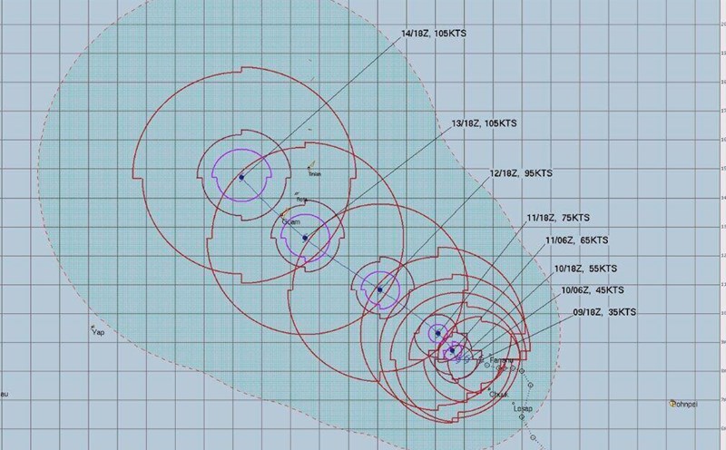
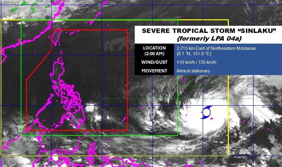
On the other side of the equator, Sinlaku tends to develop faster. According to the latest storm news from the Philippine Atmospheric, Geophysical and Astronomical Services Administration (PAGASA), at 4 am on April 11, the storm center was located at 8.1 degrees north latitude; 151.0 degrees east longitude, 2,715km northeast of Mindanao. The strongest wind near the storm center is 110 km/h, gusting 135 km/h.
Storm forecasts show that this system may strengthen into a Category 3 or 4 storm as it approaches Guam island early next week. If this scenario occurs, the area may experience heavy rain over 300mm along with strong typhoon-level winds, even approaching super typhoons.
The mechanism of formation of a double storm originates from a strong and humid wind moving eastward at low latitudes. When encountering the equator, this air flow is "divided in half", forming two symmetrical monsoons. Under the influence of the Coriolis effect, the two storms will rotate in opposite directions - a typical feature of this phenomenon.
According to experts, strong winds related to this pair of storms may contribute to promoting the formation of El Nino this year. Western winds will push warm water masses from the central Pacific region eastward, towards the South American coast - an important starting step of the El Nino process.
As warm water spreads in the eastern Pacific, more thunderstorms will form, leading to an increase in winds from the west. This process creates an amplified loop - called Bjerknes feedback - making El Nino increasingly strong and difficult to reverse.
History has recorded the role of storms in strengthening El Nino. Before El Nino 1997-1998, a series of major storms in both hemispheres contributed to creating unusually strong west winds. Similarly, in 2015, major storms in the Pacific also contributed to amplifying "super El Nino" causing global weather fluctuations.
In the current context, although there are no signs of direct impact on the East Sea, experts warn that this region is unlikely to stand outside climate fluctuations if El Nino forms and strengthens. This means the risk of increased heat, changing rain distribution and the storm season may become more complicated in the coming months.