The latest storm news from the Internal Security Agency and the Guam Civil Defense Office on the morning of April 10 said that tropical depression 04W has been upgraded to a tropical storm with the international name Sinlaku.
Forecast, strong winds from 63 km/h may appear in Guam from early morning April 13 to evening of the same day or early morning April 14. Guam Island may welcome storm winds with winds from about 119 km/h or more.
Besides, a slow-moving storm could bring heavy rainfall and significant flood risks to the island" - the storm bulletin stated.
For comparison, Typhoon Mawar in 2023 once devastated Guam with winds equivalent to super typhoons, up to about 241 km/h. Mawar also moved very slowly when passing through the area, making the level of damage more serious.
According to monitoring data on the morning of April 10 from the US Navy's Joint Typhoon Warning Center (JTWC), Sinlaku is forecast to approach the southernmost area of Guam.
It is still early to accurately determine the distance to Guam, but the storm's impact will spread far from the center due to strong wind circulation covering most of the Mariana Islands. The risk of a strong storm getting very close to Guam is still significant" - storm forecasters noted.
The US National Weather Service in Tiyan reported that at 7 am on April 10, Typhoon Sinlaku was about 113km north-northwest of Chuuk, with maximum winds of about 64 km/h.
The storm is moving northeast towards the Mariana Islands at a very slow speed, only about 4.8 km/h.
Meanwhile, the latest storm news from the Philippine Atmospheric, Geophysical and Astronomical Services Administration (PAGASA) on the morning of April 10 said that Typhoon Sinlaku has not yet affected the weather in the Philippines.
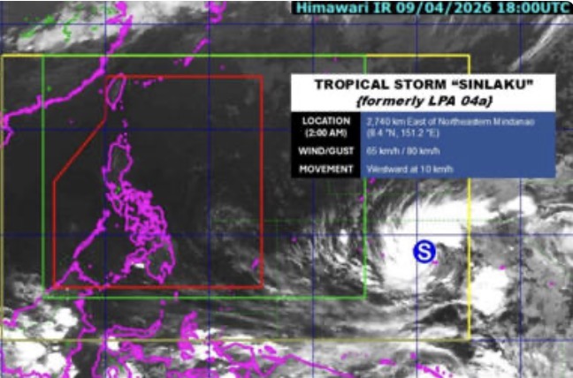
The latest storm is about 2,725km northeast of Mindanao. Typhoon Sinlaku has maximum sustained winds of 65 km/h near the center, gusts up to 80 km/h.
The system is moving westward at a speed of 10 km/h, continuing to move towards the Philippine Area of Responsibility (PAR).
Philippine weather forecasters predict that Sinlaku may enter PAR next week, around April 15-16.
After entering this area, Sinlaku may strengthen into a higher-level tropical storm and does not rule out the possibility of reaching super typhoon level.
However, the possibility of the storm making landfall directly on the mainland of the Philippines is assessed as low, although the storm may move along the eastern edge of PAR.
Even if it does not make landfall, the system can still cause large waves and strong winds affecting the eastern region of the country as it approaches Philippine waters.


