The latest typhoon bulletin on the afternoon of April 10 from the US National Weather Service (NWS) in Guam said that Typhoon Sinlaku could cause damage equivalent to Super Typhoon Mawar in 2023 if it continues to move on its current trajectory.
Strong winds may last in Guam for about 48 hours, from the morning of April 13 to the morning of April 15, as Sinlaku is forecast to strengthen into a Category 3 or 4 storm before reaching the area.
Guam Governor Lou Leon Guerrero may declare a COR 3 status on April 10. COR 3 means damaged winds may occur within the next 48 hours.
Mr. Brandon Aydlett, head of science and operations at the US National Weather Service (NWS) in Guam, said: "Typhoon Mawar is a wake-up call for many people. This situation may be similar to Mawar".
According to him, storm forecast models show the possibility of medium to strong storm conditions, with only a small possibility that Guam will only be affected by weaker tropical storm winds, below 120 km/h.
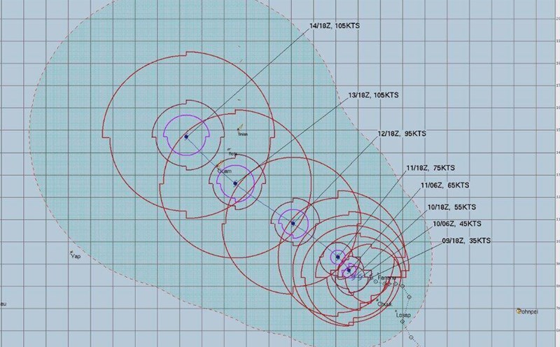
As of the afternoon of April 10, models lean towards the scenario of Sinlaku strengthening into a Category 3 storm, with winds from 178-208 km/h. However, a Category 4 storm scenario, with winds up to about 251 km/h is still possible. Less likely is the worst-case scenario: Category 5 super typhoon, with winds possibly approaching 320 km/h.
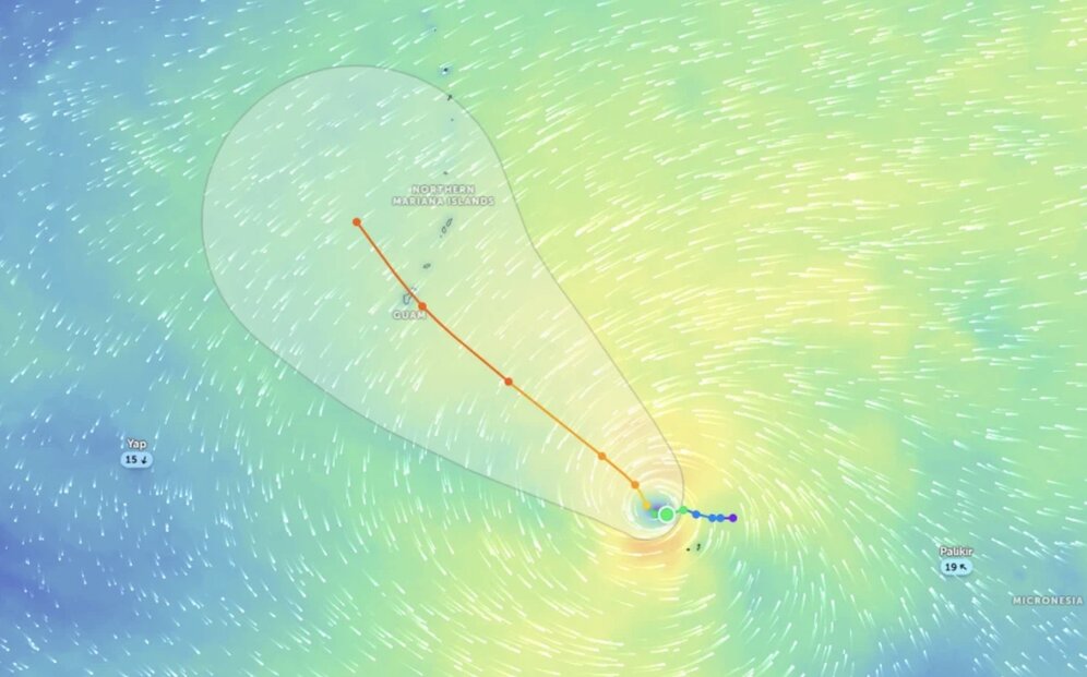
The latest forecast on April 10 shows that the eye of the storm may pass near the southern area of Guam and this is where the strongest wind will be.
However, the storm's impact may spread within a range of 160-320km from the storm center. If the direction changes, islands such as Rota and Saipan may still be affected.
If Sinlaku goes straight through southern Guam, the northern part of the island can minimize the greatest damage. "Currently, caution is needed and consider that the entire Guam is at risk of being directly affected by the storm's eye," he said.
Notably, Sinlaku is moving slowly, similar to Typhoon Mawar in 2023. Slow speed means that the typhoon has more time to strengthen, and may cause stronger winds and more rain when passing through Guam.
Meanwhile, the latest storm bulletin from the US Navy's Joint Typhoon Warning Center (JTWC) assessed that Typhoon Sinlaku continues to strengthen and move towards the Mariana Islands.
JTWC forecasters warn that Typhoon Sinlaku may reach a higher level as it approaches the Northern Mariana Islands (CNMI) early next week. On April 10, the storm's center was about 970km southeast of Saipan, moving slowly northwest.
Current forecasts show that the closest approach to CNMI may be March 12, when strong tropical storm winds, even higher, may begin to affect the area.
Typhoon Sinlaku's path may slightly deviate to the north or south, these small changes may significantly affect wind and rainfall at Saipan, Tinian and Rota islands.
Current forecasts show that the southern CNMI area may record rainfall of about 76-127 mm, along with increasingly worsening sea conditions.
For the northern islands, weather conditions are warned to worsen from the end of this week, with the possibility of strong tropical storm winds from April 14.