New storm near Philippines on track to become typhoon

Khánh Minh |

A tropical depression near the Philippines has strengthened into Typhoon Bebinca and is on track to continue to intensify.

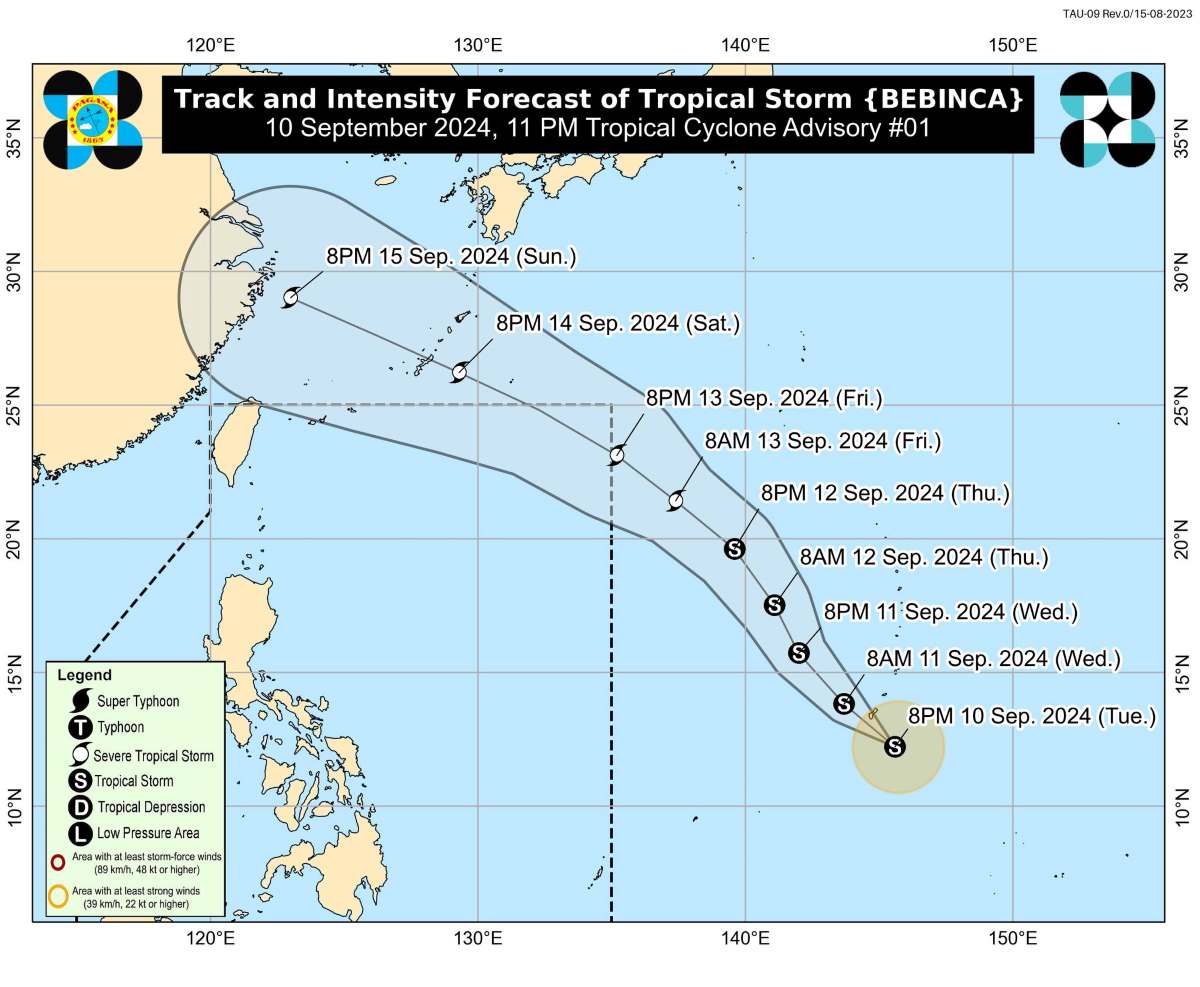
The latest storm news from the Philippine Atmospheric, Geophysical and Astronomical Services Administration (PAGASA) said that at 11pm on September 10, the tropical depression outside the forecast area (PAR) strengthened into storm Bebinca.

The eye of the storm is located at approximately 12.7 degrees north latitude, 145.0 degrees east longitude, 2,105 km east of Eastern Visayas. Maximum sustained winds near the eye are 65 km/h, gusting to 80 km/h, and the central pressure is 998 hPa. Wind radius is 200 km from the eye.

PAGASA's storm forecast said Bebinca is expected to move mainly northwestward until the evening of September 13, then may turn west-northwestward.

Du bao duong di cua bao Bebinca den ngay 15.9.2024. Anh: PAGASA
Forecasted path of Typhoon Bebinca until September 15, 2024. Photo: PAGASA

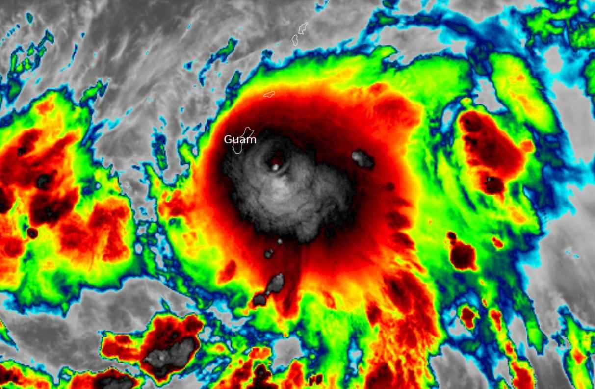
Meanwhile, according to the National Weather Service and the US Joint Typhoon Warning Center, at 11 p.m. on September 10, Typhoon Bebinca was 96 kilometers southeast of the US territory of Guam in the western Pacific Ocean, moving northwest at a speed of 20 kilometers per hour.

Ngay 10.9, bao nhiet doi Bebinca hinh thanh gan lanh tho Guam cua My o phia tay Thai Binh Duong va du kien ​​se manh len khi di chuyen ve phia tay bac. Anh: Met Office Storms
Tropical Storm Bebinca formed near the US territory of Guam in the western Pacific Ocean on September 10 and is expected to strengthen as it moves northwest. Photo: Met Office Storms

Bebinca is expected to strengthen into a severe tropical storm by the morning of September 13. The possibility of Bebinca strengthening into a typhoon cannot be ruled out, as the storm is still over the Pacific Ocean.

The current track scenario shows that Bebinca will not directly impact any part of the Philippines, but is expected to intensify the southwest monsoon, causing rains in Visayas and Palawan, and thunderstorms in Bicol and Mindanao from September 12 onwards.

However, the rainfall scenario is still subject to change depending on the track and intensity of Storm Bebinca.

Khánh Minh
RELATED NEWS

Storm No. 6 evokes the haunting super typhoon of the strongest in the world 2024

|

Hurricane No. 6 Francine is being compared by many to the strongest superstorm Beryl in the world in 2024, making landfall in southeastern Texas (USA) on July 8.

Low pressure near the East Sea continues to strengthen, causing great impact

|

According to the latest storm news from the Philippines, the low pressure area near the East Sea will be named Ferdie when it strengthens into a storm.

The double low pressure near the East Sea may strengthen into a storm this week

|

Storm No. 3 Yagi has just left, a double low pressure has appeared near the East Sea, and is likely to strengthen into a storm.

Hailstorm accompanied by strong gusts of wind suddenly appears in Lam Dong

|

Lam Dong - Hailstorms accompanied by strong gusts of wind suddenly appeared in many eastern areas of the province, many green trees fell.

Workshop "Improving the efficiency of green credit capital flows, a driving force for economic growth

|

The workshop "Improving the efficiency of green credit capital flows, a driving force for economic growth" will be a forum to remove bottlenecks in accessing green credit.

Lacking specialized personnel, Hong Phuc Clinic still self-announces health check-ups

|

Da Nang - Inspectors point out many shortcomings at Hong Phuc General Clinic, from specialized personnel, professional records to tax obligations.

Storm No. 6 evokes the haunting super typhoon of the strongest in the world 2024

Ngọc Vân |

Hurricane No. 6 Francine is being compared by many to the strongest superstorm Beryl in the world in 2024, making landfall in southeastern Texas (USA) on July 8.

Low pressure near the East Sea continues to strengthen, causing great impact

Khánh Minh |

According to the latest storm news from the Philippines, the low pressure area near the East Sea will be named Ferdie when it strengthens into a storm.

The double low pressure near the East Sea may strengthen into a storm this week

Ngọc Vân |

Storm No. 3 Yagi has just left, a double low pressure has appeared near the East Sea, and is likely to strengthen into a storm.