PAGASA's morning weather forecast on July 26 said that Typhoon Co May (called Emong in the Philippines) is currently a tropical depression. The system left the Philippine PAR forecast area on the same morning, no longer directly affecting any areas of the Philippines. It is forecasted that Co May will weaken further as it continues to move away from the Philippines.
The system was most recently identified 500km northeast of Itbayat, Batanes, Philippines, with maximum sustained winds of 55km/h in the center and gusts of up to 70km/h. The tropical depression is moving northeast at a speed of 45 km/h.
In addition to Co May, San Francisco (called throughout the Philippines as Dante) has weakened into a tropical depression as it is 640km north of Itbayat, Philippines and has now dissipated.
The tropical storm outside the PAR, internationally known as Krosa, is located 2,315km east of Northern Luzon, Philippines and is not expected to enter the Philippine forecast area.
However, the southwest monsoon or habagat will continue to affect the west of the Philippines and may be slightly strengthened by Krosa in the coming days.
Rainfall of 50 to 100mm is still possible in Ilocos, Zambales, Bataan and Occidental Mindoro, which could lead to flash floods and landslides, especially in saturated areas.
PAGASA's weather forecast for July 26 states that during the day, most of Luzon will be cloudy with scattered showers and thunderstorms. Milder rainfall is forecast than in previous days, but there is still a possibility of local heavy rain.
The southwest monsoon is forecast to continue to bring scattered rains to Zambales and Bataan on July 27, while scattered rains are also forecast for Ilocos, Pangasinan and Occidental Mindoro.
By July 28, Typhoon Krosa could increase the monsoon season slightly, increasing the likelihood of moderate to heavy rains in Ilocos Sur, La Union, Pangasinan, Zambales and Bataan.
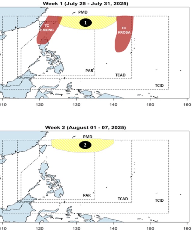
The latest storm and low pressure forecast from the Philippine Atmospheric, Geophysical and Astronomical Services Administration (PAGASA) on July 25 said that there are 2 low pressure areas near the East Sea forecast to form between now and August 7.
Philippine typhoon forecasters point out that during the week of July 25 to July 31, after the two typhoons Co May and Krosa present in the PAGASA PMD forecast area, a low pressure near the East Sea will form at the northern boundary of the PMD. During the forecast period, this low pressure is unlikely to strengthen into a typhoon.
Also during the week of July 25 to 31, the Grassroots will affect Northern Luzon, Philippines, then move north, towards the Taiwan (China) and Ryukyu regions. Meanwhile, Typhoon Krosa will strengthen outside the Philippines' forecast area and is likely to head south of Japan.
The Philippine weather agency forecasts that in the week from August 1 to 7, a second low pressure near the East Sea is expected to form. Forecast models show the depression forming north of the PMD, with the potential to strengthen into a typhoon.