Low pressure appears in large numbers near the East Sea, exceeding the forecast speed of experts

Thanh Hà |

The third low pressure near the East Sea appeared on the morning of July 22, marking 3 consecutive days of a new low pressure appearing right after Typhoon Wipha.

The latest storm information on July 22 from the Philippine Atmospheric, Geophysical and Astronomical Services Administration (PAGASA) said that the low pressure near the East Sea LPA 07g inside the Philippine Forecast Area (PAR) is currently likely to strengthen into a tropical depression within the next 24 hours.

The LPA 07g depression formed on July 21 and is currently about 1,140 km east of Central Luzon.

The LPA 07:00 depression has also been monitored within the PAR since July 20 and is still likely to strengthen into a tropical depression within the next 24 hours at an average level. This low pressure is closest to the East Sea, about 225 km from Bascos, Batanes, Philippines.

The third low pressure, LPA 07i outside the PAR, which formed on the morning of July 22, is forecast to become a tropical depression in the next 24 hours at an average level. LPA 07i is about 2,850 km east of Eastern Visayas, Philippines.

Philippine typhoon forecasters say the low pressure system is not currently directly affecting the weather in the country but will strengthen the southwest monsoon, or habagat, in the coming days.

Du bao bao, ap thap gan Bien Dong cua PAGASA ngay 21.7. Anh: PAGASA
PAGASA's forecast of storms and low pressure near the East Sea on July 21. Photo: PAGASA

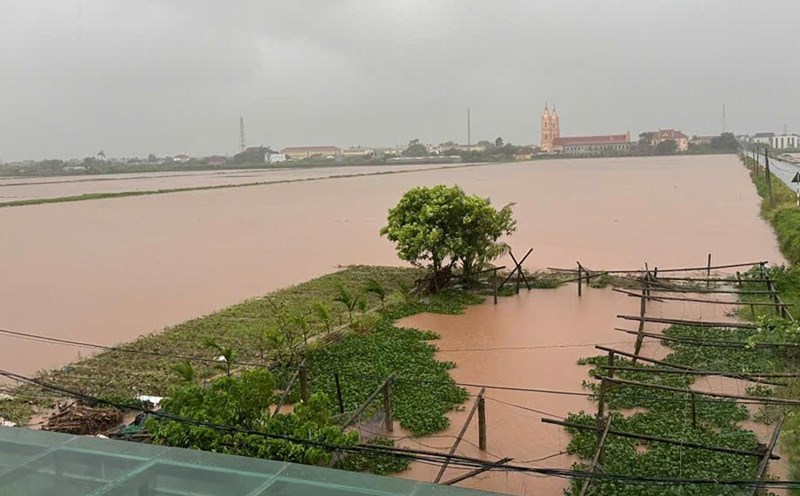
Three low pressure areas near the East Sea appeared in the context of Typhoon Wipha - the third storm in the East Sea - making landfall in Vietnam. Typhoon Wipha originated from a low pressure area near the Philippines and strengthened into a storm, locally named Crising. The next typhoon to hit the Philippines this year is Dante.

The appearance of 3 low pressure areas near the East Sea for 3 consecutive days is considered faster than PAGASA's estimated for storms and low pressure areas.

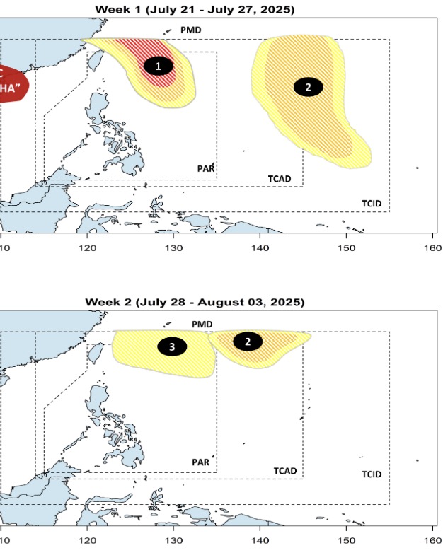
In the forecast bulletin published on July 21, PAGASA stated that during the week from July 21 to July 27, a low pressure area near the East Sea will move north, towards northern Taiwan (China), with a high possibility of continuing to strengthen into a storm.

Also during this forecast period, a second low pressure near the East Sea will appear at the eastern boundary of PAGASA's TCAD and TCID forecast areas. This second low pressure is forecast to strengthen at a low to moderate level.

During the week from July 28 to August 3, the low pressure near the East Sea No. 2 will continue to maintain its influence. This low pressure is likely to move northwest of the TCAD forecast area, the possibility of strengthening is still low to moderate.

PAGASA weather forecasters said that during this period, the third low pressure near the East Sea will appear at the northeastern boundary of the PAR. This low pressure is likely to be a new low pressure or a remnant of a system that strengthened from the first low pressure.

Thanh Hà
TIN LIÊN QUAN

Another low pressure area near the East Sea appears, forecast to strengthen soon

|

The second low pressure near the East Sea appeared on the night of July 21 after the low pressure formed on the night of July 20. One of the two depressions is likely to strengthen before or during July 23.

Low pressure appears near the East Sea as storm Wipha is moving into the Gulf of Tonkin

|

The low pressure near the East Sea appeared from the night of July 20 in the context of Typhoon Wipha active in the East Sea.

Storm Wipha enters the East Sea, forecast 3 low pressure areas forming in a row

|

Typhoon Wipha did not make landfall in the Philippines as initially forecast and is moving into the East Sea. It is forecasted that right after storm No. 3 in the East Sea, 3 consecutive depressions will appear.

Identifying the male body drifting in Ha Long Bay on the morning of July 22

|

Quang Ninh - This male body was identified as one of the victims of the sinking of the Green Bay tourist boat 58, license plate QN-7105 on July 19.

High-rise house fire on Giai Phong Street, Hanoi

|

Hanoi - A high-rise house on Giai Phong Street suddenly caught fire fiercely on the afternoon of July 22. The authorities quickly arrived at the scene to put out the fire.

Hung Yen recovers after storm, people start taking to the streets, many trees fall

|

Hung Yen - On the afternoon of July 22, the weather in some wards such as Pho Hien, Nam Son, Hong Chau stabilized again after storm No. 3.

65,000 hectares of rice in Ninh Binh submerged in water

|

Ninh Binh - The whole province has about 74,017 hectares of rice fields affected by storm No. 3, of which the area of white flooding is 65,489 hectares.

To propose salary increase as a driving force for development

|

Mr. Le Dinh Quang - Former member of the National Wage Council shared in depth and frankly about the proposals to adjust the regional minimum wage in the coming time.

Another low pressure area near the East Sea appears, forecast to strengthen soon

Thanh Hà |

The second low pressure near the East Sea appeared on the night of July 21 after the low pressure formed on the night of July 20. One of the two depressions is likely to strengthen before or during July 23.

Low pressure appears near the East Sea as storm Wipha is moving into the Gulf of Tonkin

Thanh Hà |

The low pressure near the East Sea appeared from the night of July 20 in the context of Typhoon Wipha active in the East Sea.

Storm Wipha enters the East Sea, forecast 3 low pressure areas forming in a row

Thanh Hà |

Typhoon Wipha did not make landfall in the Philippines as initially forecast and is moving into the East Sea. It is forecasted that right after storm No. 3 in the East Sea, 3 consecutive depressions will appear.