According to the latest weather bulletin of the Philippine Atmospheric, Geophysical and Astronomical Services Administration (PAGASA) on September 22, tropical depression Igme has left the Philippine forecast area (PAR) but continues to strengthen the southwest monsoon, affecting the weather in many areas of the Philippines.
Tropical Depression Igme is the fourth weather system to affect the Philippine monsoon after Ferdie, Gener and Helen. Tropical Storm Ferdie left PAR on September 14, while Gener and Helen left PAR on September 18 and Igme left PAR on the morning of September 21.
Due to the influence of typhoons, depressions and monsoons in the Philippines, cloudy skies with scattered rains and thunderstorms were recorded in Batanes and Babuyan Islands as well as Metro Manila, the rest of Luzon and Western Visayas on September 22.
The death toll from the combined effects of typhoons, tropical depressions Ferdie, Gener, Helen and Igme along with the southwest monsoon in the Philippines has risen to 25, according to the latest information from the Philippines' National Disaster Risk Reduction and Management Council (NDRRMC).
There are 1,449,333 individuals or 387,755 families in the Philippines affected by these weather disturbances. Currently, 23,512 individuals or 5,783 families remain in 199 evacuation centers across the Philippines. In addition, the combined impact of these weather phenomena was also recorded on 122 roads and 14 bridges across the Philippines.
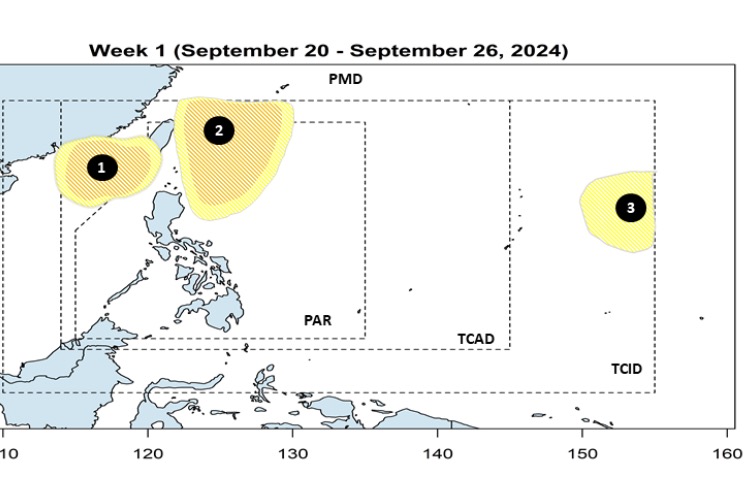
According to the storm and low pressure forecast for the second half of September announced by the Philippine weather agency on September 20 for the next two weeks, during the week from September 20 to 26, no tropical storms will form in the PMD (PAGASA Monitoring Domain) of PAGASA.
However, during this forecast period, Philippine weather forecasters said that there is a possibility of at least 3 tropical depressions forming, with 2 depressions likely to form in the northern East Sea or near the East Sea.
The first depression is forecast to form in the northwestern boundary of the Philippine Forecast Area (PAR) and the second depression is forecast to develop near the northeastern part of Luzon, within the Philippine Forecast Area. Both depressions are forecast to intensify into tropical storms.
The third depression is likely to develop east of the PAGASA Tropical Cyclone Information Domain (TCID) boundary. It is also likely to intensify into a typhoon near the Philippines.
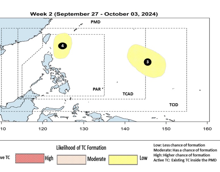
PAGASA's storm and low pressure forecast for the week of September 27 to October 3 indicates that this week, the third low pressure formed from the previous week will be in the eastern part of PAGASA's Tropical Cyclone Advisory Domain (TCAD) and TCID forecast areas. This low pressure is likely to move westward.
Storm and low pressure forecast models predict that a fourth low pressure system near the Philippines is likely to develop in the northeastern part of the country’s forecast area this week. However, both low pressure systems No. 3 and No. 4 have little chance of strengthening into storms.


