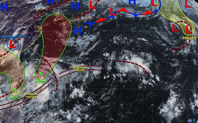
The Philippine Atmospheric, Geophysical and Astronomical Services Administration (PAGASA) said that at 2:00 a.m. on August 17, the center of the tropical depression in the East Sea was at about 16 degrees North latitude, 111.8 degrees East longitude, 880km west of Central Luzon.
PAGASA weather forecaster Robert Badrina said that this tropical depression will not directly affect the Philippines. However, the low pressure trough has affected the Ilocos region, Zambales and Bataan, where showers and thunderstorms are possible.
According to the National Meteorological Administration, Metro Manila, Cavite, Batangas, Occidental Mindoro and Palawan will experience similar weather patterns due to the influence of the southwest monsoon.
The rest of the Philippines will be cloudy with scattered showers due to local thunderstorms in the next 24 hours.
Meanwhile, according to the Vietnam National Center for Hydro-Meteorological Forecasting, at 1:00 a.m. on August 17, the tropical depression had an intensity of level 6 (39-49km/h), gusting to level 8, moving northwest at a speed of about 10km/h.
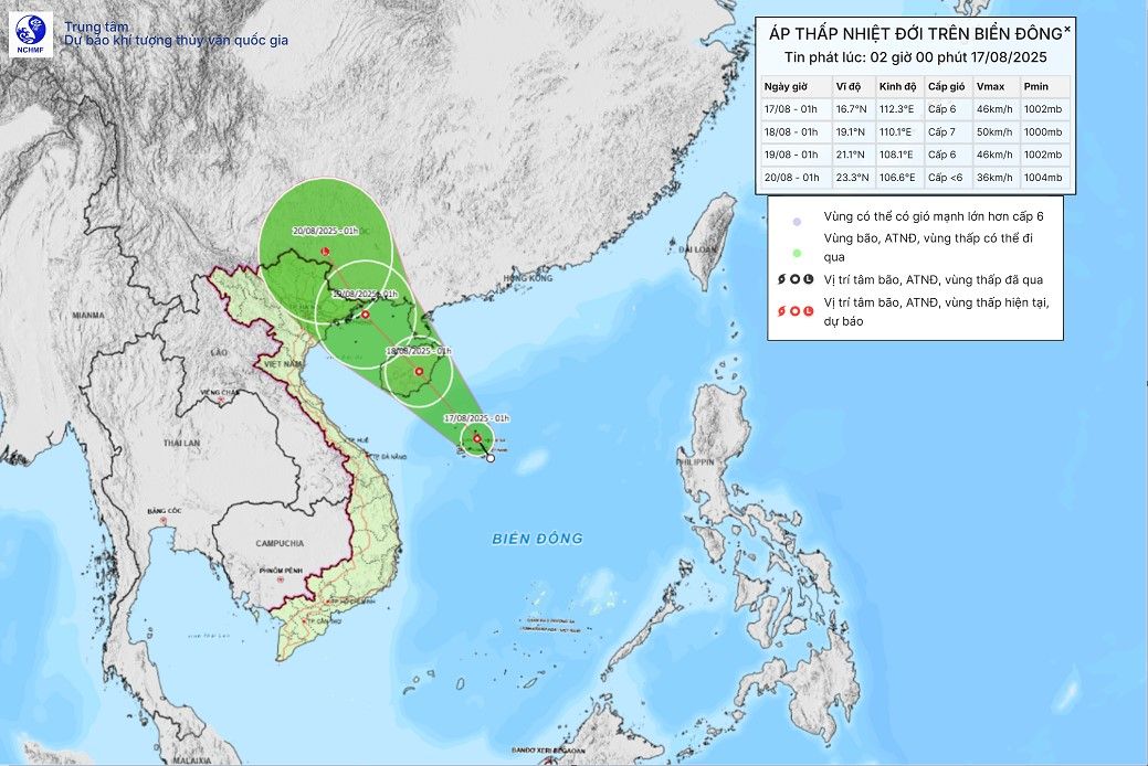
It is forecasted that by 1:00 a.m. on August 18, the center of the tropical depression will be at 19.1 degrees North latitude, 110.1 degrees East longitude; on the mainland east of Hainan Island (China). Strong wind level 6-7, gust level 9. The tropical depression is moving northwest at about 15km/h. The sea area west of the North East Sea (including the sea area of Hoang Sa special zone) is at risk of level 3 natural disasters.
At 1:00 a.m. on August 19, the center of the tropical depression was at 21.1 degrees North latitude, 108.1 degrees East longitude; in the North of the Gulf of Tonkin. Strong winds of level 6, gusting to level 8, moving northwest at 10-15km/h. The sea area west of the North East Sea, the sea area north of the Gulf of Tonkin is at risk of level 3 natural disasters.
In the next 72 hours, the tropical depression will move northwest at a speed of 10-15km/h, gradually weakening.
Due to the influence of the tropical depression, the sea area west of the North East Sea (including the sea area of Hoang Sa special zone) will have thunderstorms, strong winds of level 6-7, gusts of level 8-9. Waves are 2.0-3.5m high. Strong seas.
From the morning of August 18, the sea area of the Gulf of Tonkin will gradually increase to level 6, gusting to level 8. Waves are 2.0-3.0m high. Rough seas.
Ship operating in dangerous areas are likely to experience thunderstorms, whirlwinds, strong winds and large waves.