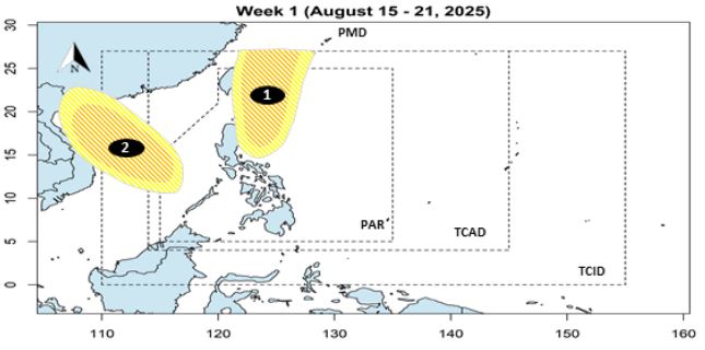
The Philippine Atmospheric, Geophysical and Astronomical Services Administration (PAGASA) forecasts that during the week of August 15-21, 2025, there is a possibility of the formation of 2 low pressure areas in the Philippine Forecast Area (PAR), with a probability of moderate to low strengthening into storms.
Low pressure 1 may appear near eastern Luzon, moving towards eastern Taiwan (China).
Low pressure 2 is forecast to form in the West Philippine Sea (South China Sea) and move towards Hainan Island (China) and Northern Vietnam.
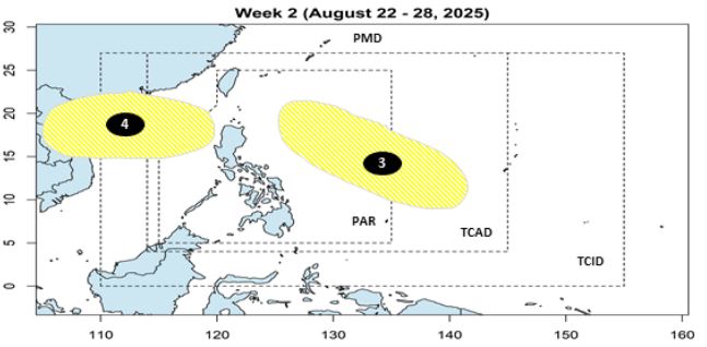
During the week of August 22-28, 2025, PAGASA forecasts that there will continue to be the possibility of the formation of 2 new low pressure areas, but the probability of strengthening into storms is low.
Low pressure 3 may form east of the PAR, towards the east of Northern Luzon.
Low pressure 4 is forecast to appear in the Northwest of PAR, moving towards Hainan (China) and Northern Vietnam.
Meanwhile, the Vietnam National Center for Hydro-Meteorological Forecasting forecasts that on August 16, the low pressure area formed in the central East Sea will move slowly in the North-Northwest direction and is likely to strengthen into a tropical depression.
Due to the influence of the low pressure, on August 16, the central East Sea area will have winds of level 5, sometimes level 6, gusting to level 7-8. Rough seas. Waves are 2-3.5m high.
The North of the North East Sea will have winds of level 5, sometimes level 6, gusting to level 7-8. Rough seas. Waves are 2-3.5m high.
To the East of the South China Sea (including the sea area east of Truong Sa area), winds of level 5, sometimes level 6, gusting to level 7-8. Rough seas. Waves are 2-3.5m high.
From Khanh Hoa to Ho Chi Minh City and the West of the South China Sea (including the sea area west of Truong Sa) wind level 6, gust level 7-8. Rough seas. Waves are 2-3.5m high.
On August 16, the Gulf of Tonkin, the sea area from South Quang Tri to Ca Mau, Ca Mau to An Giang, the Gulf of Thailand, the North, Central and South East Sea (including the special areas of Hoang Sa and Truong Sa) will have scattered showers and thunderstorms. During thunderstorms, there is a possibility of tornadoes, strong gusts of wind and waves over 3.5m high.
On the night of August 16 and August 17, the sea area from Lam Dong to Ho Chi Minh City and the western sea area of the South China Sea (including the western sea area of Truong Sa) will have strong southwest winds of level 6, gusting to level 7-8, waves 1.5-3.5m high; rough seas.
The sea area north of the North East Sea will have strong East to Southeast winds of level 6, gusting to level 7-8, waves from 2.0-3.5m high; rough seas.
The central East Sea area has strong winds of level 6, gusts of level 7-8, waves 2.0-3.5m high; rough seas.