Typhoon Podul gusts to level 13, new low pressure accumulates to threaten the East Sea

Song Minh |

According to the latest storm news, on the morning of August 12, Typhoon Podul strengthened into a Category 12 storm, gusting to Category 13.

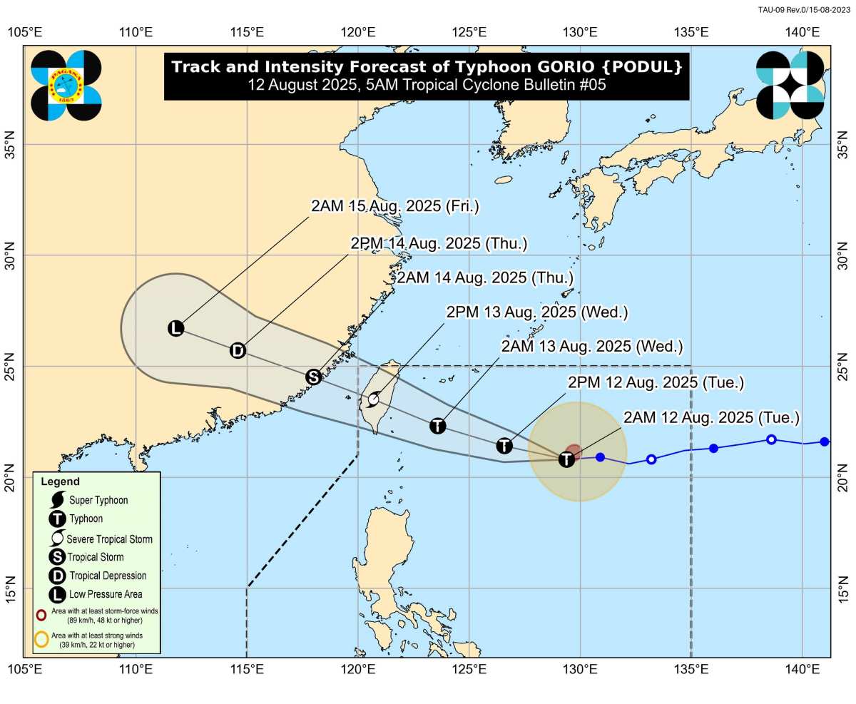
In the storm forecast bulletin at 5:00 a.m. on August 12, the Philippine Atmospheric, Geophysical and Astronomical Services Administration (PAGASA) said that Typhoon Podul (local name: Typhoon Gorio) had the strongest winds of 120 km/h (level 12, gusts of wind have now increased to 150 km/h (level 13,).

The center of the storm is located at about 20.7 degrees north latitude, 129.0 degrees east longitude, 745km east of Itbayat, Batanes.

The storm is moving west at a speed of 25 km/h, still heading towards Taiwan (China), where the storm could make landfall on August 13.

Du bao duong di cua bao Podul (Gorio). Anh: PAGASA
Forecast of the path of Typhoon Gorio (Podul). Photo: PAGASA

PAGASA said Typhoon Podul is unlikely to directly affect the weather in the Philippines in the next 3 days. However, if the storm's path moves south, strong winds could sweep the northernmost part of Luzon and tropical cyclone signals are needed.

The meteorological agency also warned people that sea conditions in some areas of Northern Luzon could be dangerous on August 12 due to the storm.

The northern and eastern coasts of the Babuyan Islands will have waves up to 3.5m high. Small vessels should take preventive measures or avoid going to sea if possible.

The remaining seas of the Babuyan Islands; the northeastern coast of mainland Cagayan has waves up to 2.5m high.

The remaining seas of mainland Cagayan; Isabela coast; Aurora's northeastern coast, waves up to 2m high.

Typhoon Podul may leave the Philippine Forecast Area (PAR) by the evening of August 13.

This is the 7th typhoon in the Philippines in 2025, and the 2nd typhoon in August, after Typhoon Fabian.

PAGASA previously estimated that two or three tropical storms may form in or enter the PAR in August.

In addition to Typhoon Gorio (Podul), there is a possibility of two low pressure forming in the PAR this week, but the probability of them developing into storms is low.

Du bao bao/ap thap tuan tu. Anh: PAGASA
Storm/low pressure forecast for the week of August 11-17, 2025. Photo: PAGASA

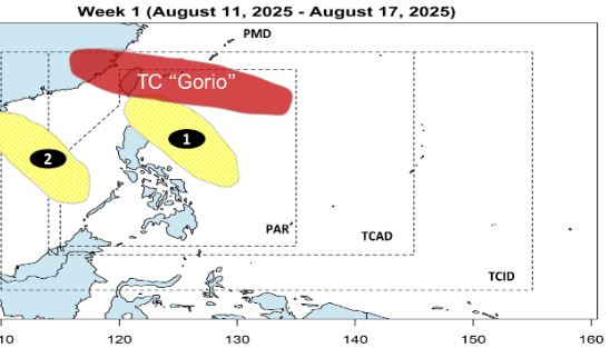
Low pressure 1 may form in the Philippine Sea and move northeast of Luzon Island.

Low pressure 2 may appear in the East Sea, then move out of the PAR.

During the week of August 18-24, the low pressure in the East Sea is likely to head towards Hainan Island (China) and Northern Vietnam, but the possibility of strengthening into a storm is still low.

Du bao ap thap tuan tu . Anh: PAGASA
Low pressure forecast for the week of August 18-24, 2025. Photo: PAGASA

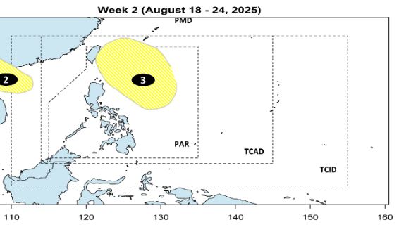
The third depression may form west of the PAGASA monitoring area (PMD), but there is also a low probability of becoming a storm.

With the above developments, the storm risk warning level during the entire forecast period has been raised, so PAGASA recommends that coastal and at sea areas should closely monitor the next weather forecasts.

Song Minh
RELATED NEWS

Storm Gorio appears near the East Sea, forecast to become a typhoon today

|

The storm, internationally known as Podul, has entered the Philippine Forecast Area (PAR) and has been locally named Gorio.

New low pressure forecast in the East Sea right after storm Podul

|

Storm forecast models show a new low pressure system could form in the South China Sea immediately following Typhoon Podul.

Typhoon Podul may strengthen into a typhoon today, forecast to be the most affected area

|

According to the latest storm news, Typhoon Podul near the Philippines strengthened into a severe tropical storm on the morning of August 10 and could become a typhoon today.

Silent heroes in the flash flood in Dien Bien

|

Dien Bien - In addition to the Head of Mua A Thi village who was recently sent a letter of commendation by the Prime Minister, there is another figure who also contributed greatly to saving nearly 100 people from the fierce flood.

Schedule to announce 2025 university admission scores: Some schools will announce early

|

Some higher education institutions have issued a schedule expected to announce the benchmark for 2025.

An Giang boy cycling alone across Vietnam to Hanoi to celebrate National Day 2.9

|

Tran Hien Vinh started his cross-court cycling journey from Ho Chi Minh City with the goal of being in Hanoi in time for the National Day holiday on September 2.

Typhoon Podul gusts to level 13, new low pressure accumulates to threaten the East Sea

|

According to the latest storm news, on the morning of August 12, Typhoon Podul strengthened into a Category 12 storm, gusting to Category 13.

28 enterprises will be honored as "Outstanding Enterprises for Workers"

|

The "Outstanding Enterprise for Workers" Award is scheduled to take place at 7:30 p.m. on August 15.

Storm Gorio appears near the East Sea, forecast to become a typhoon today

Khánh Minh |

The storm, internationally known as Podul, has entered the Philippine Forecast Area (PAR) and has been locally named Gorio.

New low pressure forecast in the East Sea right after storm Podul

Khánh Minh |

Storm forecast models show a new low pressure system could form in the South China Sea immediately following Typhoon Podul.

Typhoon Podul may strengthen into a typhoon today, forecast to be the most affected area

Khánh Minh |

According to the latest storm news, Typhoon Podul near the Philippines strengthened into a severe tropical storm on the morning of August 10 and could become a typhoon today.