The latest hurricane information from the US National Hurricane Center (NHC) said that on the morning of October 13 (local time), tropical storm Lorenzo formed in the central Atlantic, about 1,850km west of the Cabo Verde Islands and about 4,230km east of Florida (USA).
At 11:00 a.m. on October 13 (east time), the center of storm Lorenzo was at about 14.8 degrees north latitude and 41.2 degrees west longitude, moving northwest at a speed of about 26 km/h. Maximum winds near the center of the storm are 80 km/h, gusting higher, and the central pressure is about 1,002 mb.
Typhoon models suggest that Lorenzo may continue to strengthen, but the severity is still different. Some models, including Google DeepMind and ECMWF forecasts, believe that Lorenzo could reach hurricane status - winds of 119 km/h or higher.
However, the NHC is still maintaining its assessment of Lorenzo as a tropical storm, with maximum sustained winds of 112 km/h in the next 72 hours, below the threshold to be classified as a typhoon.
Lorenzo's tropical storm-force wind zone extends up to 260km from the center of the storm. The meteorological agency forecasts that storm No. 12 Lorenzo will turn north on October 14, moving away from the Caribbean and mainland US. It is too early to determine whether Hurricane No. 12 will affect Florida or the U.S. East Coast.
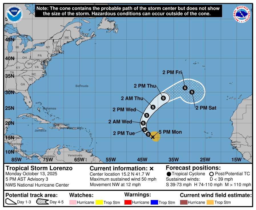
Lorenzo is the 12th named storm of the 2025 Atlantic hurricane season and the third to form since early October.
At the same time, the NHC is also monitoring another tropical disturbance in the eastern Atlantic, nearly 12 degrees north latitude, 25 degrees west longitude, moving west at a speed of about 18 km/h, accompanied by scattered showers and thunderstorms within a range of 220 km around the center.
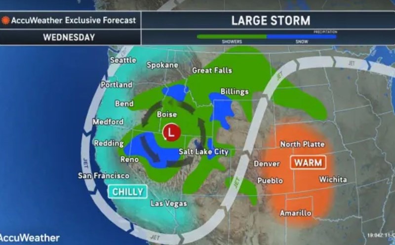
Notably, Hurricane 12 Lorenzo comes just after the first strong coastal storm of the year, Nor'easter, was causing big waves, gusts of wind and heavy rain along the U.S. East Coast, from Virginia to Massachusetts.
The National Weather Service (NWS) warned that this phenomenon could lead to flooding, power outages, traffic disruptions and rough seas with waves over 3m high.
If another tropical cyclone continues to form, the next storm on this year's list will be named Hurricane Melissa.
According to the US National Oceanic and Atmospheric Administration (NOAA), 97% of the activity of depressions/storm states occurring from June to November is the main time of the Atlantic hurricane season.
The area includes the northern Atlantic, Caribbean Sea and the Gulf of America - the new name for the Gulf of Mexico used by the US government in the map and weather forecast issued by President Donald Trump.