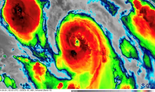
Hurricane John was forecast to be a tropical storm. However, in just one day, the latest storm in the Pacific Ocean surged into a powerful Category 3 storm, hitting the southern coast of Mexico on the evening of September 23.
With maximum sustained winds of over 190 km/h, Hurricane John made landfall two days earlier than previously forecast. The 10th storm of the Pacific winter storm season made landfall near Marquelia, Guerrero state, about 120 km southeast of Acapulco. Landslides caused by Hurricane John have left three people dead and the risk of severe flooding persists for days.
The storm's rapid intensification is reminiscent of Hurricane Otis, which caught Acapulco off guard as it became the strongest storm ever to hit Mexico's west coast.
Although Hurricane John did not directly hit Acapulco, the city did feel the storm's impact, with heavy rain and flooding expected to last for several days.
Hurricane John was downgraded to a tropical storm on the morning of September 24 but is still forecast to bring up to 760mm of rain to coastal areas through September 26. The storm's impact could lead to deadly disasters such as flash floods and landslides, the US National Hurricane Center warned.
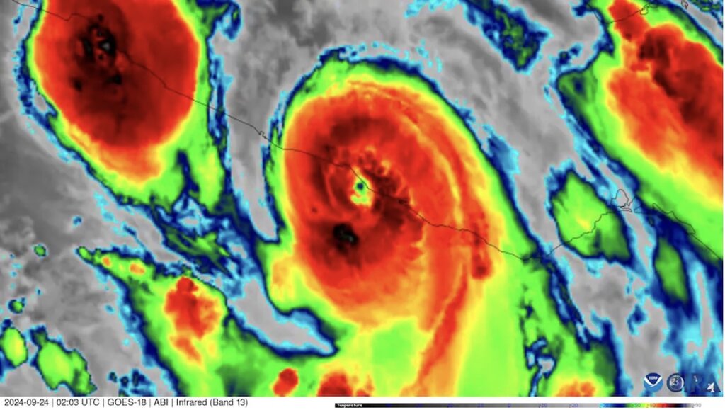
Hurricane John's maximum sustained winds increased to 85 mph (135 km/h) within 24 hours of the National Hurricane Center's hurricane bulletin, rising from 35 mph (55 km/h) to 119 mph (190 km/h). Hurricane John made landfall at approximately 9:15 p.m. on September 23 as the strongest September storm to ever hit the Mexican state of Guerrero.
Last year, Hurricane Otis made a similar change as it approached the state’s coast. Otis stunned forecasters when it spiked to 90 mph in 12 hours and 115 mph in 24 hours before hitting Acapulco last October. Otis made landfall as a Category 5 storm with maximum sustained winds of 165 mph.
A weather station near Acapulco recorded one of the strongest wind gusts ever recorded in the world during Hurricane Otis, reaching 200 mph (330 km/h). Most computer models predicted that Hurricane Otis would only strengthen to a Category 1 hurricane.
In 2015, Hurricane Patricia, which struck a sparsely populated area on Mexico’s southwestern coast, holds the record for the most intensification in a single day. Hurricane Patricia’s winds increased to a record 120 mph (190 km/h) in 24 hours, making it the strongest hurricane ever recorded, with peak winds of nearly 217 mph (350 km/h).
Several studies have shown that hurricanes are rapidly intensifying due to warming ocean waters caused by climate change. Like Hurricane Otis, Hurricane John started out relatively small. Hurricane researchers also note that smaller storms can intensify more quickly than larger ones, making them harder to predict.