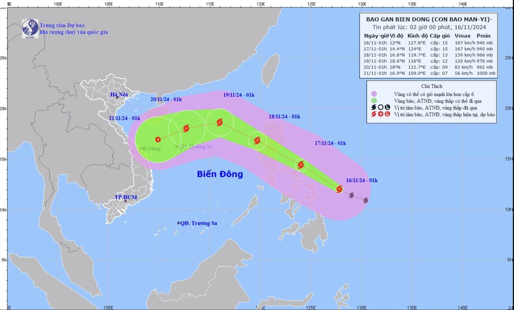
The latest storm news from the Philippine weather agency on the morning of November 16 said that storm Man-yi (local name Pepito) is threatening Southern Luzon and Eastern Visayas, Philippines with intensity approaching super typhoon level.
The storm bulletin released at 5 a.m. said the center of Typhoon Man-yi was 220 kilometers east-northeast of Borongan City, Eastern Samar, or 305 kilometers east of Catarman, Northern Samar.
The storm has maximum sustained winds of up to 175 km/h near its center, with gusts of up to 215 km/h. Typhoon Man-yi is moving west-northwest at 25 km/h and has typhoon-force winds extending up to 440 km from its center.
Typhoon Man-yi is forecast to move west-northwest over the next three days before turning west to west-southwest from the evening of November 18 to the morning of November 20.
According to the latest typhoon forecast by PAGASA, Man-yi is likely to make landfall in the vicinity of Catanduanes on the evening of November 16 or early morning of November 17. However, the scenario of this storm near the South China Sea making landfall on the east coast of Camarines Sur, Albay or Sorsogon in the same time frame or making landfall along the east coast of Quezon or Aurora in the afternoon or evening of November 17 is also not ruled out.
Typhoon Man-yi is forecast to enter the East Sea on the evening of November 17 or the morning of November 18 and leave the Philippines PAR forecast area on November 18.
Storm forecasters specifically noted that Typhoon Man-yi will continue to strengthen on November 16 and could reach super typhoon status in the next few hours before making landfall on the night of November 16 or the morning of November 17.
Typhoon Man-yi will largely weaken by November 17 as it moves across Central Luzon. Overall, the storm near the South China Sea will sweep the Philippines as a typhoon and is likely to weaken to a strong tropical storm as it moves into the South China Sea on November 18.
If it strengthens into a super typhoon, Man-yi will become the second super typhoon this week to hit the Philippines. Previously, Typhoon Usagi (locally known as Ofel) made landfall as a super typhoon on November 14.

Typhoon Usagi is currently moving slowly in the waters west of Taiwan (China). At 4:00 a.m. on November 15, the center of Typhoon Usagi was 240 km northwest of Itbayat, Batanes, Philippines. This storm near the East Sea has maximum sustained winds of up to 75 km/h near the center, with gusts of up to 90 km/h.
Typhoon Usagi is forecast to move northeast today (November 16), make landfall in southern Taiwan (China) and enter the eastern waters of the island early in the morning of November 17.
Usagi is forecast to continue weakening due to increasingly unfavorable weather conditions and interaction with the mountainous terrain of Taiwan. The once super typhoon could be downgraded to a low pressure system by November 17 or even earlier.


