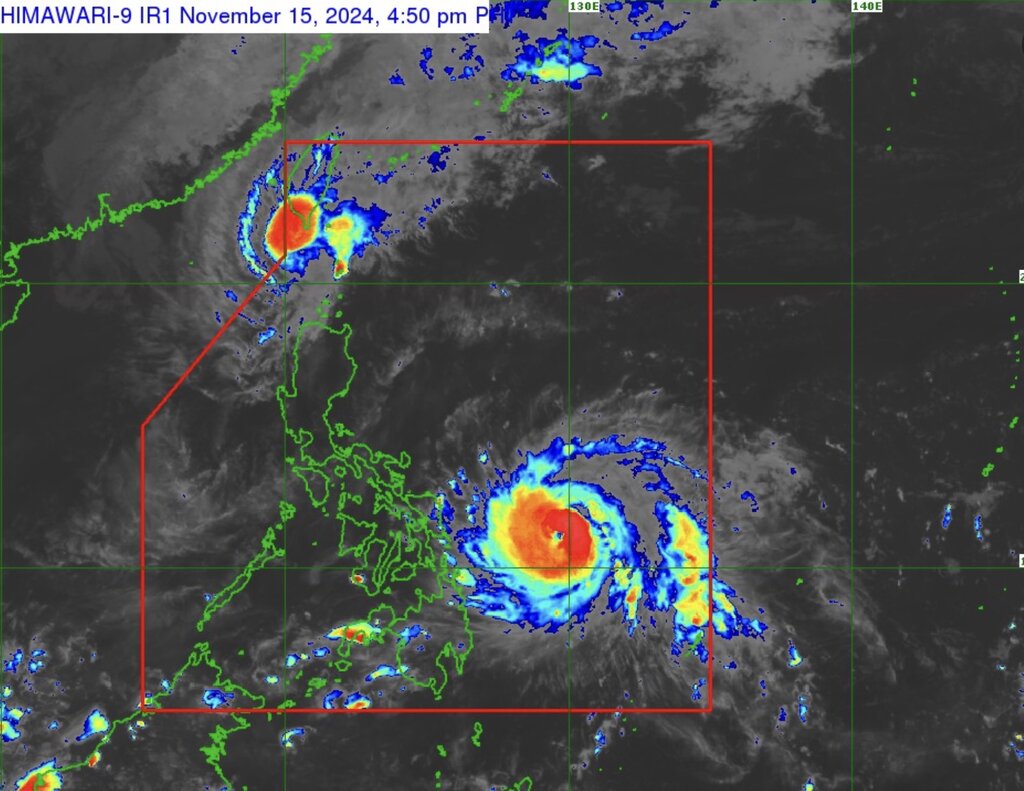
The latest typhoon bulletin from the Philippine weather agency PAGASA said that Typhoon Man-yi (local name Pepito) is rapidly intensifying. The eye of the storm is 465 km east of Guiuan, Eastern Samar, Philippines.
Maximum sustained winds near the center of the storm are 150 km/h, with gusts of up to 185 km/h. This storm near the East Sea is moving west-northwest at 30 km/h. Typhoon Man-yi's hurricane-force winds extend up to 440 km from the center of the storm.
Philippine typhoon forecasters say Typhoon Man-yi will move west-northwest over the next five days. It is likely to make landfall in the vicinity of Catanduanes on the evening of November 16 or early morning of November 17.

However, another scenario for Man-yi’s path is for the storm to make landfall on the east coast of Camarines Sur, Albay or Sorsogon on the evening of November 16 or early morning of November 17. A third scenario is for Man-yi to make landfall on the east coast of Northern Samar on the afternoon or evening of November 16. Forecasters also do not rule out the possibility of the storm making landfall along the east coast of Quezon or Aurora on the afternoon or evening of November 17.
Regardless of where it makes landfall, Typhoon Man-yi is expected to enter the East Sea on the evening of November 17 or the morning of November 18.
PAGASA’s latest storm forecast predicts that Typhoon Man-yi will rapidly intensify from November 15 to 16 and may become a super typhoon before making landfall on the evening of November 16 or the morning of November 17. It is forecast that Man-yi will weaken slightly when it makes landfall and sweep across the Philippines at typhoon strength. When it enters the South China Sea on November 18, Man-yi is likely to be a strong tropical storm.
Man-yi is one of two storms currently active near the South China Sea, the other being Usagi (locally known as Ofel). Latest developments show that Usagi is weakening and is outside the Philippine PAR forecast area. However, Usagi may return to PAR tonight (November 15).
At 4:00 p.m. on November 15, the center of storm Usagi was 205 km west-northwest of Itbayat, Batanes, with maximum sustained winds near the center of 100 km/h, gusting to 125 km/h.
Typhoon Usagi is forecast to move to the southwestern waters of Taiwan (China) from the evening of November 15 to the early morning of November 16. This storm near the East Sea is forecast to make landfall in southwestern Taiwan (China) in the morning or afternoon of November 16. After sweeping the island, Usagi will move to the eastern waters of Taiwan (China) on November 17.
International typhoon forecasters all agree that Usagi - the storm that once strengthened into a super typhoon - will continue to weaken throughout the forecast period due to increasingly unfavorable conditions and interactions with the mountainous terrain of Taiwan (China). By the evening of November 17 or early morning of November 18, Usagi will be just a low pressure area.


