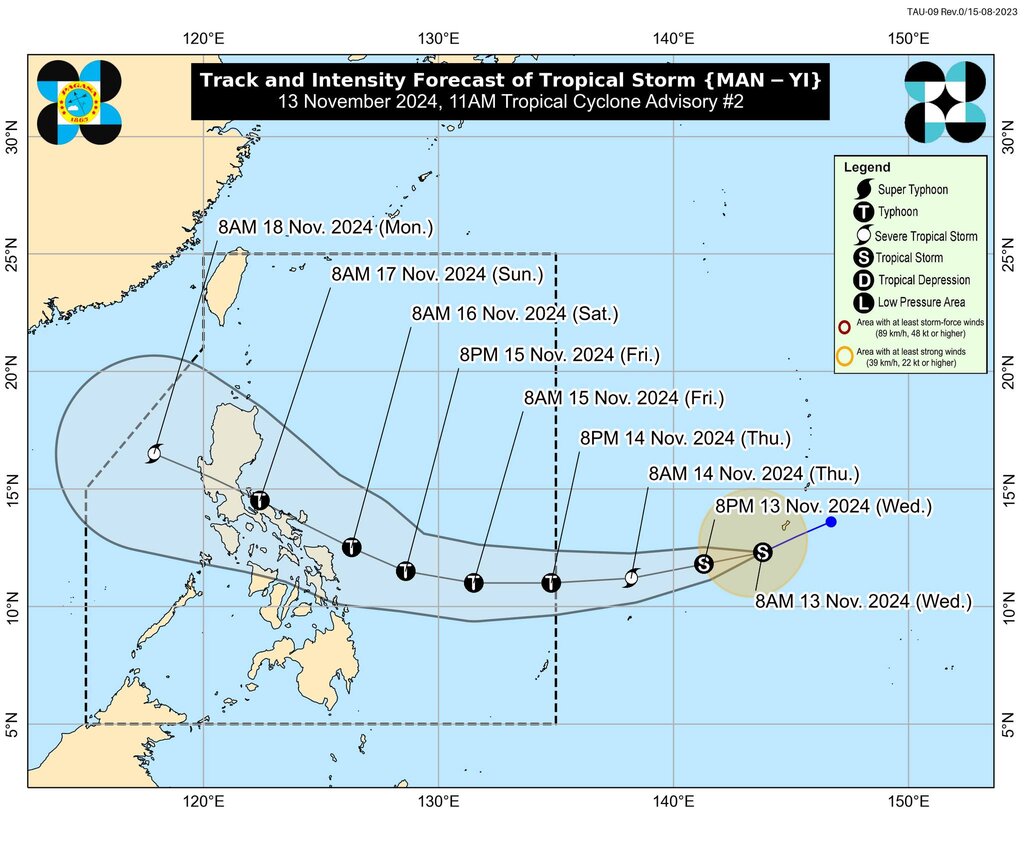
The latest storm information from the Philippine weather agency PAGASA said that Typhoon Man-yi is continuing to move west-southwest in the eastern Philippines.
Typhoon Man-yi is located 1,965 km east of Eastern Visayas, outside the Philippines PAR forecast area. Maximum sustained winds near the center of the storm are 65 km/h, with gusts of up to 80 km/h. The storm is currently moving west-southwest at 30 km/h.
PAGASA's typhoon bulletin noted that due to the high pressure area south of Japan, Typhoon Man-yi is forecast to move southwestward over the next 12 hours before turning west and approaching the PAR forecast area of the Philippines. Typhoon Man-yi is expected to enter the PAR area from the evening of November 14 and has been locally named Pepito.
Philippine typhoon forecasters said that within the PAR forecast area, Typhoon Man-yi will move west or west-northwest on November 15 before turning northwest on November 16 for the remainder of the forecast period.
Typhoon Man-yi is forecast to make landfall on the eastern coast of Luzon, Philippines, over the weekend (November 16 or 17). However, forecasters note that the path of Typhoon Man-yi is still likely to change, especially on the 4th and 5th days of the forecast period (ie the time when the storm makes landfall in the Philippines and enters the East Sea).

Typhoon Man-yi is forecast to strengthen into a severe tropical storm today, maintain this intensity for 24 hours, and then become a typhoon in the afternoon or evening of November 14. Experts do not rule out the possibility of Typhoon Man-yi rapidly strengthening.
Notably, since Man-yi is likely to strengthen into a typhoon as it moves across the Philippine Sea, forecasters are not ruling out the possibility of the storm becoming a super typhoon before making landfall. Man-yi could make landfall in the Philippines at its peak intensity.
Man-yi is one of three storms currently active around the Philippines. Typhoon Toraji (Philippine name: Nika) is currently storm number 8 in the South China Sea while Typhoon Usagi (Philippine name: Ofel) is active in the Philippine Sea, within the Philippines' PAR forecast area.
According to the latest storm information on Typhoon Usagi released by PAGASA at 11:00 a.m. on November 13, Typhoon Usagi is strengthening as it moves west-northwest over the Philippine Sea. The center of the storm is located 485 km east-northeast of Daet, Camarines Norte, Philippines, with maximum sustained winds near the center of 120 km/h and gusts of up to 150 km/h.
Usagi is forecast to make landfall along the eastern coast of Cagayan or Isabela, Philippines on the afternoon of November 14. The storm will then cross the Luzon Strait on November 15 and turn more northward. Usagi is forecast to be erratic this weekend, with the storm likely to loop and head toward the South China Sea. Usagi is forecast to steadily strengthen over the next 24 hours and could make landfall at peak intensity.


