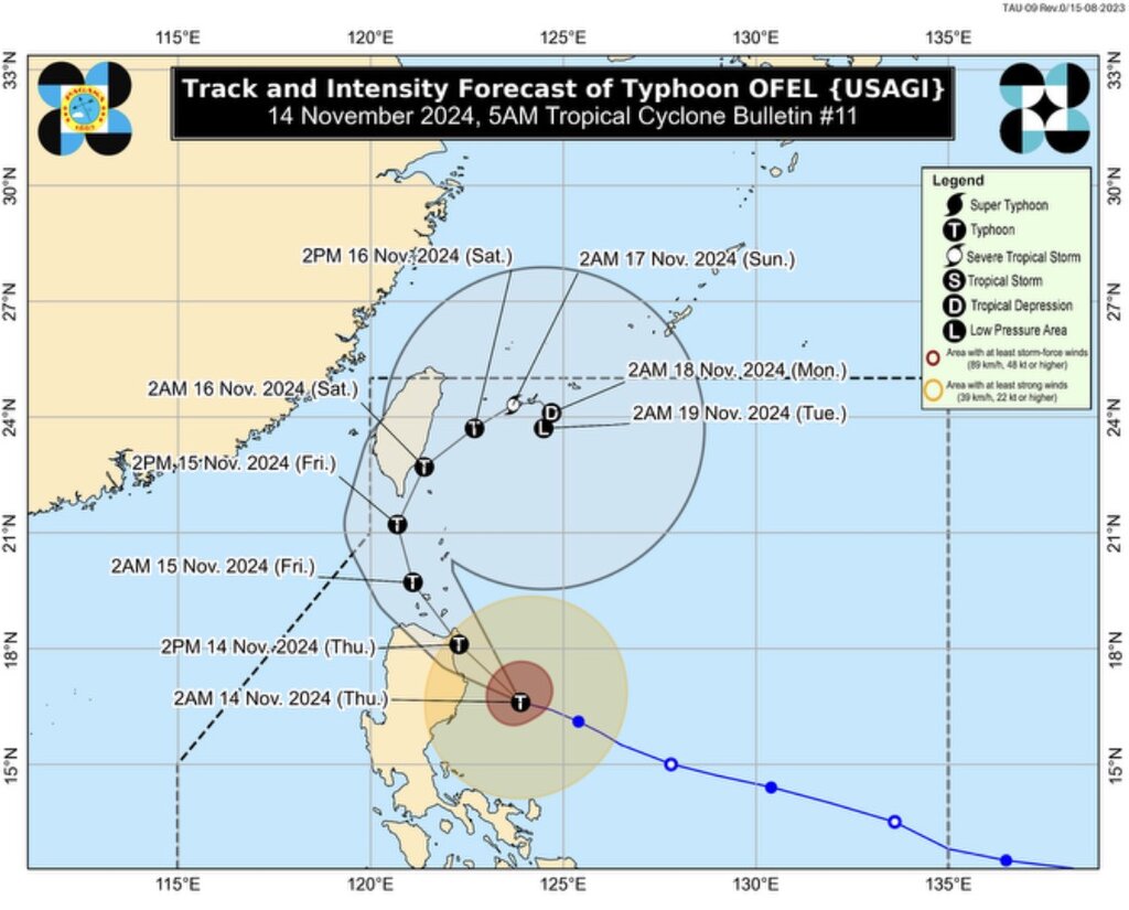
The latest storm bulletin from the Philippine weather agency PAGASA released at 5 a.m. on November 14 said that Typhoon Usagi (local name: Ofel) is intensifying violently and reaching near super typhoon level when it is 215km east of Echague, Isabela, Philippines.
The storm is moving west-northwest at 30 km/h. Maximum sustained winds near the center of Usagi are up to 165 km/h, with gusts up to 205 km/h.
Philippine typhoon forecasters said that Typhoon Usagi is expected to move northwest over the Philippine Sea before making landfall along the east coast of Cagayan or north of Isabela, Philippines this afternoon (November 14).
The storm will then move through the Babuyan Strait near the East Sea on the evening of November 14 when it makes a second landfall or approaches the Babuyan Islands.
Typhoon Usagi is forecast to turn northward over the sea west of Batanes on November 15 before turning northeastward from November 16 over the sea east of Taiwan (China) to the Ryukyu Islands during the remaining forecast period.

Forecasters warn that the path of Typhoon Usagi is still likely to shift. The storm is expected to strengthen over the next 12 hours and could make landfall during its peak intensity.
Because Typhoon Usagi is moving in a favorable environment for strengthening, it is possible that this storm will reach super typhoon level.
Weakening of Usagi is likely as the storm moves closer to Taiwan. The storm is likely to become a low pressure area in the Ryukyu Islands on November 18 or 19.
The latest storm information from the US Navy's Joint Typhoon Warning Center (JTWC) said that Typhoon Usagi has strengthened into a super typhoon, with winds of up to 240 km/h and is likely to make landfall as a super typhoon.
Usagi is one of several storms currently active near the South China Sea. South China Sea typhoon Toraji is active south of China and is weakening into a tropical depression while Typhoon Man-yi is heading toward the Philippines.
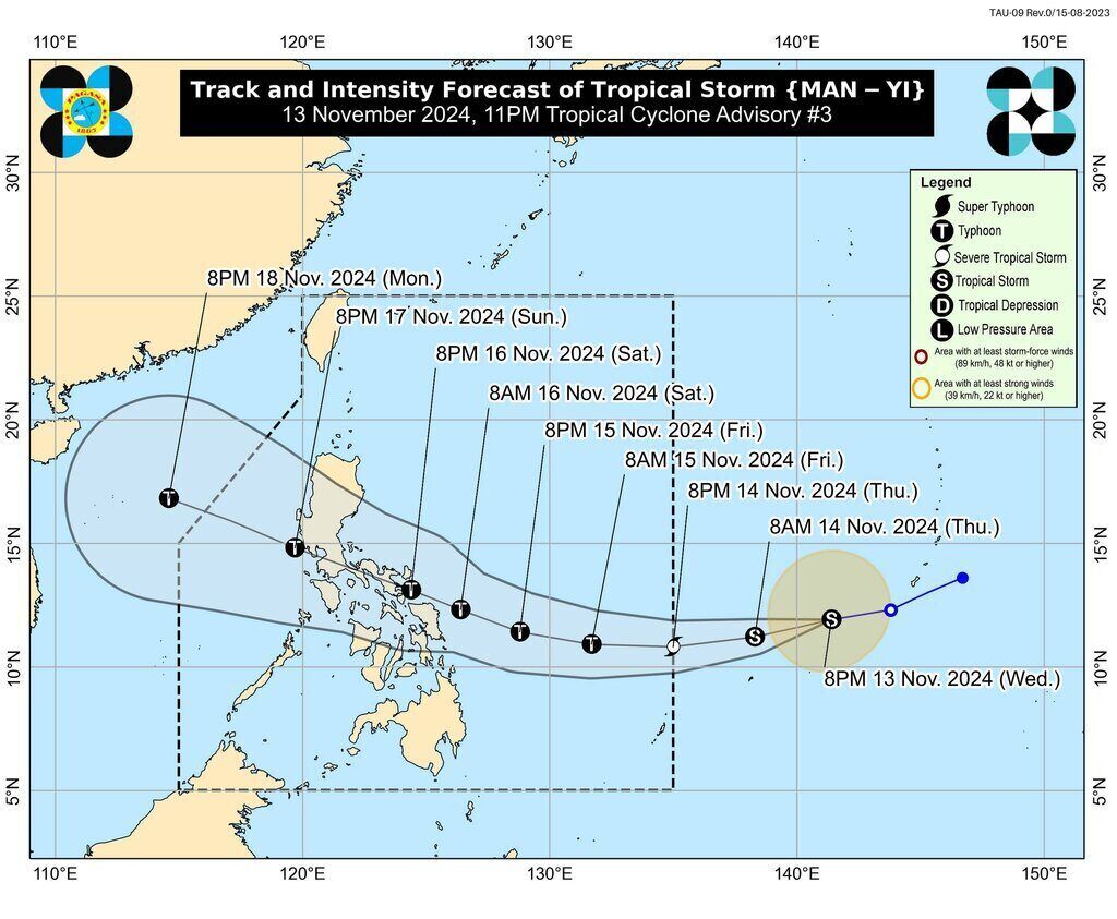
According to PAGASA’s latest typhoon bulletin on Typhoon Man-yi, the storm is slightly intensifying as it continues to move westward. The center of Typhoon Man-yi is 1,705 km east of Eastern Visayas, Philippines and is outside the Philippine PAR forecast area.

Man-yi is packing maximum sustained winds of 75 km/h near the center, with gusts of 90 km/h. The storm is moving west at 30 km/h. The storm's gust zone extends up to 300 km from the center.
PAGASA said that Typhoon Man-yi will enter the Philippine PAR forecast area on November 14 and will be locally named Pepito. In the PAR, Typhoon Man-yi is forecast to gradually move westward until November 15 before turning west-northwestward from November 16.
According to forecasts, this storm near the East Sea is expected to make landfall on the eastern coast of Southern Luzon, Philippines this weekend (November 16 or 17). After sweeping across the Philippines, Typhoon Man-yi is forecast to enter the East Sea on November 17-18, becoming the ninth storm in the East Sea.
Forecasters in the Philippines say that Man-yi is likely to strengthen into a typhoon by the evening of November 14 or the morning of November 15. The possibility of the storm intensifying into a super typhoon before making landfall in the Philippines cannot be ruled out. Man-yi is likely to make landfall at its maximum intensity.


