Global weather at risk of chaos due to abnormalities in the Pacific

Song Minh |

Unusual fluctuations are forming deep in the Pacific Ocean, which is considered the "brain" controlling global weather.

New satellite data shows that La Nina is weakening faster than expected, paving the way for a new El Nino that could disrupt the climate, food and economy of the world from 2026-2027.

In the central Pacific Ocean, under the calm water and beyond normal observation, a large-scale atmosphere-ocean phase transition is accelerating.

Wind direction islands that used to appear sporadically are now becoming clearer, accompanied by increasingly expanding heat anomalies. Climate scientists believe La Nina is collapsing rapidly, while El Nino has just begun to emerge.

El Nino - La Nina, also known as the Southern Hemisphere Oscillation ENSO, is one of the natural mechanisms that has the most profound impact on the Earth's climate system.

When entering the warm phase of El Nino, global rain distribution is disrupted, the frequency of storms, droughts and floods increases in many areas. Although "initiated" from the Pacific, ENSO's impact spreads far beyond all national borders.

The latest data from satellites and ocean buoys shows that a warm water "crash" is forming at a depth of 100-250m in the western Pacific and is trending eastward.

This is considered an early and quite certain sign of El Nino. Many scientists predict that El Nino conditions may appear from mid-2026, with a clear impact in the 2026-2027 climate season.

Du lieu ve tinh cho thay di thuong nhiet be mat phu hop voi El Nino dang hinh thanh tren Thai Binh Duong. Anh: NASA
Satellite data shows surface temperature anomalies consistent with El Nino forming in the Pacific Ocean. Photo: NASA

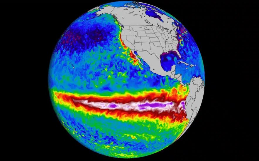
The worrying point lies in the phase transition speed. In early January, meteorologists recorded unusual strong westerly winds lasting through the western and central equatorial regions of the Pacific.

These signals are reinforced by the combined models of the European Center for Medium-Term Forecasting (ECMWF) and the US Center for Climate Forecasting (CPC).

El Nino is not just an ocean story. When it appears, it restructures large atmospheric circulations, shifts convection zones and changes global pressure balance.

In North America, El Nino usually leads to a more humid winter in the southern United States and California, while Canada and the northern United States tend to be warmer. Atlantic storm activity is often restrained by strong winds.

In the Asia-Pacific region, El Nino is associated with the risk of prolonged drought and heat waves. Australia and Indonesia often bear great pressure on water resources, reduced monsoons and the risk of wildfires. For Indonesia, this impact can spread to the energy and mining sectors, affecting strategic commodities such as nickel or bauxite.

South America is also not outside the vortex. Pacific countries such as Peru and Ecuador often suffer unusually heavy rains, causing flooding and agricultural damage, while the Amazon rainforest may be drier, increasing the risk of forest fires.

Song Minh
RELATED NEWS

The first storm in 2026 caused consequences greater than heavy rain and gusts of wind

|

Not only stopping at heavy rains and gusts of wind, the first storm in 2026 in the Northwest Pacific storm has left serious consequences.

Extremely strong cold air next week, in some places drops to 16 degrees Celsius

|

An extremely strong cold air mass is expected to sweep through China until mid-week, causing heavy rain, snowfall and widespread frost.

The first storm in 2026 is expected to be particularly dangerous

|

Typhoon Ada - the first storm in 2026 - is moving in an unusual direction in the Philippine Sea, forecast to be particularly dangerous.

La Nina collapse: Storm season, 2026 weather before dangerous turning point

|

La Nina is entering the "collapse" phase, which may reshape the weather patterns of 2026, from storms to unpredictable climate phenomena.

Forecast of severe cold developments in the 2 peak months of winter

|

Forecast for January and February - the main winter months, cold air will continue to be weaker than average but widespread cold spells may still appear.

Secretary of Bac Ninh Provincial Party Committee Nguyen Hong Thai: Building Bac Ninh into a centrally-run city before 2030

|

In the atmosphere of the 14th National Party Congress, Comrade Nguyen Hong Thai, Member of the Party Central Committee, Secretary of the Bac Ninh Provincial Party Committee, interviewed central and local press agencies about the vision, goals and major orientations to build Bac Ninh to develop rapidly, sustainably, modernly, and with rich identity; striving to become a centrally-run city before 2030.

Fall of canal banks in Ho Chi Minh City

|

Ho Chi Minh City - Ho Chi Minh City functional forces are blocking Ba Dinh street, Chanh Hung ward after a 50m long canal bank subsidence incident.

Truck fire on Cam Lam - Vinh Hao expressway, traffic congestion of more than 1km

|

Khanh Hoa - A truck fire while traveling on the Cam Lam - Vinh Hao expressway caused traffic congestion through the area lasting more than 1km.

The first storm in 2026 caused consequences greater than heavy rain and gusts of wind

Khánh Minh |

Not only stopping at heavy rains and gusts of wind, the first storm in 2026 in the Northwest Pacific storm has left serious consequences.

Extremely strong cold air next week, in some places drops to 16 degrees Celsius

Song Minh |

An extremely strong cold air mass is expected to sweep through China until mid-week, causing heavy rain, snowfall and widespread frost.

The first storm in 2026 is expected to be particularly dangerous

Song Minh |

Typhoon Ada - the first storm in 2026 - is moving in an unusual direction in the Philippine Sea, forecast to be particularly dangerous.

La Nina collapse: Storm season, 2026 weather before dangerous turning point

Khánh Minh |

La Nina is entering the "collapse" phase, which may reshape the weather patterns of 2026, from storms to unpredictable climate phenomena.