After months of dominating global weather, La Nina is entering a rapidly weakening phase, opening up the possibility of a new El Nino forming right next summer.
Climate forecasters warn that this large reversal in the Pacific Ocean may trigger extreme weather fluctuations in 2026, especially related to storms and floods.
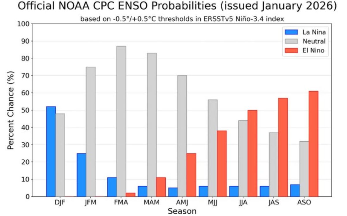
Currently, sea surface temperatures in the eastern equatorial Pacific region are still lower than average - a typical sign of La Nina, a phenomenon that started in October and lasted until early this year.
However, according to the US Centers for Climate Prediction (CPC), this state is gradually losing momentum. The probability of La Nina transitioning to the neutral state ENSO in the period from February to April is up to over 80%, showing that a change is coming very soon.
Although La Nina weakened, its impact on the atmosphere did not disappear immediately. Meteorologists believe that La Nina's "resistances" may still affect early spring, creating a complex transitional weather period, when atmospheric systems have not yet stabilized to a new state.
What experts are particularly interested in is the possibility of El Nino appearing in the summer, at the most sensitive time of the Atlantic hurricane season.
El Nino formed when sea surface temperatures in the central - eastern Pacific region increased by at least 0.5 degrees Celsius above average for many consecutive months. If this scenario occurs, global weather patterns could be severely disrupted.
In many cases, El Nino increases high-altitude winds in the Caribbean and Atlantic regions, a factor that can inhibit the development of storms. However, experts emphasize that this is not an absolute "shield". Even in the years of El Nino, just a strong storm forming in favorable conditions is enough to cause serious damage.
The level of risk in the upcoming storm season depends greatly on the intensity and timing of El Nino's formation. A strong El Nino, with a clear increase in sea temperature, will have a wider impact on global atmospheric circulation than a weak El Nino. At the same time, the exact location of warm waters in the Pacific also determines how rain, storms and heat will be distributed in each region.
La Nina is often associated with cooler and hotter weather in the northern United States, while El Nino tends to bring more rain to the southern region. When phase transitions occur rapidly, familiar weather patterns may be disrupted, increasing the risk of extreme phenomena.
Weather forecasters believe that in the next few months, what will happen in the Pacific Ocean will play a key role in shaping the weather for the whole year 2026.
The "collapse" of La Nina does not mean a more peaceful period, but may be the beginning of a new uncertain cycle, where storms and extreme phenomena become more unpredictable than ever.


